![](/images/other/stat-length.png)
![Excursión Senderismo Salazie - Forêt de Belouve - Photo](https://media.geolcdn.com/t/1900/400/ext.pjpeg?maxdim=2&url=https%3A%2F%2Fstatic1.geolcdn.com%2Fsiteimages%2Fupload%2Ffiles%2F1553511878bg_sport_marche.png)
Forêt de Belouve
Fdum
Usuario
![Longitud](/images/other/stat-length.png)
Longitud
11,4 km
![Altitud máxima](https://static1.geolcdn.com/siteimages/upload/files/1508320355ic_sort_altitude_max_24dp.png)
Altitud máxima
1573 m
![Desnivel positivo](https://static1.geolcdn.com/siteimages/upload/files/1508320355ic_sort_den_pos_24dp.png)
Desnivel positivo
305 m
![Km-Effort](/images/other/stat-length.png)
Km-Effort
15,5 km
![Altitud mínima](https://static1.geolcdn.com/siteimages/upload/files/1508320355ic_sort_altitude_min_24dp.png)
Altitud mínima
1350 m
![Desnivel negativo](https://static1.geolcdn.com/siteimages/upload/files/1508320355ic_sort_den_neg_24dp.png)
Desnivel negativo
305 m
![Boucle](https://static1.geolcdn.com/siteimages/upload/files/16400158638029165_repeat_loop_refresh_sync_direction_icon.png)
Boucle
Sí
Fecha de creación :
2016-03-09 00:00:00.0
Última modificación :
2016-03-09 00:00:00.0
![Senderismo](https://static1.geolcdn.com/sitytour/trail-icons/101.png)
3h25
Dificultad : Fácil
![Escanee este código QR para abrir la excursión en la aplicación SityTrail](https://capi.geolives.com/qq0zvz2zws4bq2lad0pu/sitytour/trails/412574/qr.png?size=200)
Aplicación GPS de excursión GRATIS
A propósito
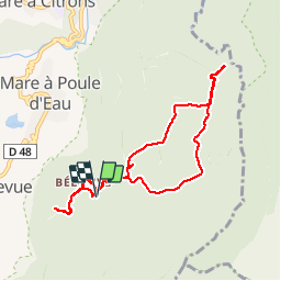
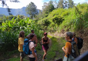
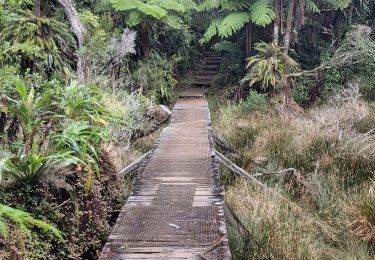
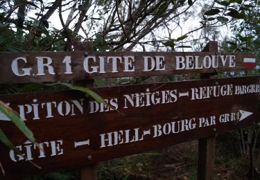
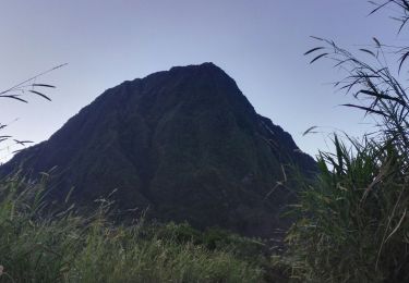
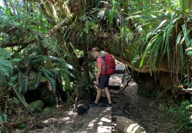
Ruta Senderismo de 11,4 km a descubrir en La Reunión, Desconocido, Salazie. Esta ruta ha sido propuesta por Fdum.
Descripción
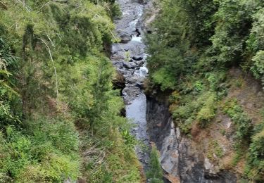
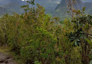
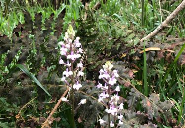
Belle promenade en forêt et vue sur le trou de fer. Nouveau belvédère 2014. Belles vues aussi sur le cirque de SALAZIE.
Localización
País:
France
Región :
La Reunión
Departamento/provincia :
Desconocido
Municipio :
Salazie
Localidad:
Unknown
Salida:(Dec)
Salida:(UTM)
348161 ; 7670192 (40K) S.
Comentarios
Excursiones cerca
![Excursión Senderismo Salazie - mare à poules d'eau - Photo](https://media.geolcdn.com/t/375/260/ext.jpg?maxdim=2&url=https%3A%2F%2Fmedia.geolcdn.com%2Ff%2Ff233e327-af89-4e51-8952-a42deb7b065c.jpg)
![Senderismo Senderismo](https://static1.geolcdn.com/sitytour/trail-icons/101.png)
mare à poules d'eau
Senderismo
Muy fácil
(1)
Salazie,
La Reunión,
Desconocido,
France
![](/images/other/stat-length.png)
2,5 km | 3,2 km-effort
1h 23min
![](https://static1.geolcdn.com/siteimages/upload/files/16400158638029165_repeat_loop_refresh_sync_direction_icon.png)
Sí
![Excursión Senderismo Salazie - Trou de Fer par le refuge de Belouve. - Photo](https://media.geolcdn.com/t/375/260/ext.jpg?maxdim=2&url=https%3A%2F%2Fmedia.geolcdn.com%2Ff%2Fe928c1d8-2457-4a87-a207-09d9da2e6f6a.jpg)
![Senderismo Senderismo](https://static1.geolcdn.com/sitytour/trail-icons/101.png)
Trou de Fer par le refuge de Belouve.
Senderismo
Medio
Salazie,
La Reunión,
Desconocido,
France
![](/images/other/stat-length.png)
10 km | 13,5 km-effort
4h 27min
![](https://static1.geolcdn.com/siteimages/upload/files/16400158638029165_repeat_loop_refresh_sync_direction_icon.png)
Sí
![Excursión Senderismo Salazie - tour du piton maillot - rivière du mat - Photo](https://media.geolcdn.com/t/375/260/ext.jpg?maxdim=2&url=https%3A%2F%2Fmedia.geolcdn.com%2Ff%2Fb0283353-1556-4e58-b3a9-10ea62f2ed93.jpg)
![Senderismo Senderismo](https://static1.geolcdn.com/sitytour/trail-icons/101.png)
tour du piton maillot - rivière du mat
Senderismo
Medio
Salazie,
La Reunión,
Desconocido,
France
![](/images/other/stat-length.png)
12,5 km | 21 km-effort
5h 42min
![](https://static1.geolcdn.com/siteimages/upload/files/16400158638029165_repeat_loop_refresh_sync_direction_icon.png)
Sí
![Excursión A pie Salazie - Sentier du Trou de Fer - Photo](https://media.geolcdn.com/t/375/260/ext.jpg?maxdim=2&url=https%3A%2F%2Fmedia.geolcdn.com%2Ff%2Fc038aaf4-d20f-42ab-9ddd-e2e145d6cf22.jpeg)
![A pie A pie](https://static1.geolcdn.com/sitytour/trail-icons/100.png)
Sentier du Trou de Fer
A pie
Fácil
Salazie,
La Reunión,
Desconocido,
France
![](/images/other/stat-length.png)
4 km | 5,1 km-effort
1h 10min
![](https://static1.geolcdn.com/siteimages/upload/files/16400158638029165_repeat_loop_refresh_sync_direction_icon.png)
No
![Excursión Senderismo Salazie - Piton d'Anchain - Photo](https://media.geolcdn.com/t/375/260/ext.jpg?maxdim=2&url=https%3A%2F%2Fmedia.geolcdn.com%2Ff%2Fe4fe93b2-c12b-4594-ba67-cfbaedd38e68.jpg)
![Senderismo Senderismo](https://static1.geolcdn.com/sitytour/trail-icons/101.png)
Piton d'Anchain
Senderismo
Difícil
Salazie,
La Reunión,
Desconocido,
France
![](/images/other/stat-length.png)
9,1 km | 19,3 km-effort
2h 48min
![](https://static1.geolcdn.com/siteimages/upload/files/16400158638029165_repeat_loop_refresh_sync_direction_icon.png)
Sí
![Excursión Senderismo Salazie - hellbourg trou de fer aller retour - Photo](https://media.geolcdn.com/t/375/260/ext.jpg?maxdim=2&url=https%3A%2F%2Fmedia.geolcdn.com%2Ff%2Ff25ac1e5-8b40-471d-9124-c73c0cd498ae.jpg)
![Senderismo Senderismo](https://static1.geolcdn.com/sitytour/trail-icons/101.png)
hellbourg trou de fer aller retour
Senderismo
Difícil
Salazie,
La Reunión,
Desconocido,
France
![](/images/other/stat-length.png)
22 km | 37 km-effort
7h 14min
![](https://static1.geolcdn.com/siteimages/upload/files/16400158638029165_repeat_loop_refresh_sync_direction_icon.png)
No
![Excursión Senderismo Saint-Benoît - Trou de fer 05/10/19 - Photo](https://media.geolcdn.com/t/375/260/ext.jpg?maxdim=2&url=https%3A%2F%2Fmedia.geolcdn.com%2Ff%2Fe5527ee8-926b-48b9-9a90-e02a67c5d55f.jpg)
![Senderismo Senderismo](https://static1.geolcdn.com/sitytour/trail-icons/101.png)
Trou de fer 05/10/19
Senderismo
Medio
Saint-Benoît,
La Reunión,
Desconocido,
France
![](/images/other/stat-length.png)
11 km | 14,2 km-effort
4h 40min
![](https://static1.geolcdn.com/siteimages/upload/files/16400158638029165_repeat_loop_refresh_sync_direction_icon.png)
Sí
![Excursión Senderismo Salazie - Trpu de fer belouve depuis hellbourg - Photo](https://media.geolcdn.com/t/375/260/ext.jpg?maxdim=2&url=https%3A%2F%2Fmedia.geolcdn.com%2Ff%2F892a7e28-b4c3-43fd-a2b8-cc58d169f618.jpg)
![Senderismo Senderismo](https://static1.geolcdn.com/sitytour/trail-icons/101.png)
Trpu de fer belouve depuis hellbourg
Senderismo
(1)
Salazie,
La Reunión,
Desconocido,
France
![](/images/other/stat-length.png)
17,4 km | 29 km-effort
7h 26min
![](https://static1.geolcdn.com/siteimages/upload/files/16400158638029165_repeat_loop_refresh_sync_direction_icon.png)
Sí
![Excursión Senderismo Saint-Benoît - trou de fer - Photo](https://media.geolcdn.com/t/375/260/ext.jpg?maxdim=2&url=https%3A%2F%2Fservices.sitytrail.com%2FGeolivesWS%2FDownloadMedia.ashx%3FTrailID%3D398057%26Media%3Dfix__20150318134039.jpg)
![Senderismo Senderismo](https://static1.geolcdn.com/sitytour/trail-icons/101.png)
trou de fer
Senderismo
Medio
(1)
Saint-Benoît,
La Reunión,
Desconocido,
France
![](/images/other/stat-length.png)
13,6 km | 16,9 km-effort
2h 38min
![](https://static1.geolcdn.com/siteimages/upload/files/16400158638029165_repeat_loop_refresh_sync_direction_icon.png)
Sí