![](/images/other/stat-length.png)
![Excursión Senderismo Lüsen - Luson - Lüsner Alm - Rastnerhütte - Photo](https://media.geolcdn.com/t/1900/400/53568d57-db9a-4244-bdfb-b706a0b08f6b.jpg&format=pjpeg&maxdim=2)
Lüsner Alm - Rastnerhütte
VacheKiri67
Usuario
![Longitud](/images/other/stat-length.png)
Longitud
12,4 km
![Altitud máxima](https://static1.geolcdn.com/siteimages/upload/files/1508320355ic_sort_altitude_max_24dp.png)
Altitud máxima
1959 m
![Desnivel positivo](https://static1.geolcdn.com/siteimages/upload/files/1508320355ic_sort_den_pos_24dp.png)
Desnivel positivo
414 m
![Km-Effort](/images/other/stat-length.png)
Km-Effort
17,9 km
![Altitud mínima](https://static1.geolcdn.com/siteimages/upload/files/1508320355ic_sort_altitude_min_24dp.png)
Altitud mínima
1599 m
![Desnivel negativo](https://static1.geolcdn.com/siteimages/upload/files/1508320355ic_sort_den_neg_24dp.png)
Desnivel negativo
415 m
![Boucle](https://static1.geolcdn.com/siteimages/upload/files/16400158638029165_repeat_loop_refresh_sync_direction_icon.png)
Boucle
Sí
Fecha de creación :
2024-07-17 08:07:16.645
Última modificación :
2024-08-01 14:47:23.466
![Senderismo](https://static1.geolcdn.com/sitytour/trail-icons/101.png)
4h04
Dificultad : Difícil
![Escanee este código QR para abrir la excursión en la aplicación SityTrail](https://capi.geolives.com/qq0zvz2zws4bq2lad0pu/sitytour/trails/4125130/qr.png?size=200)
Aplicación GPS de excursión GRATIS
A propósito
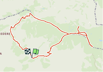
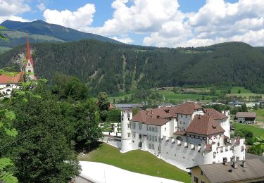
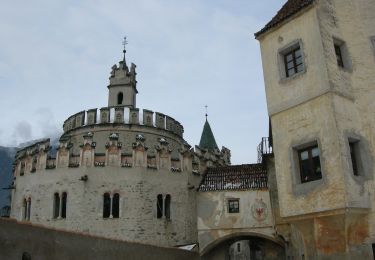
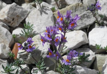
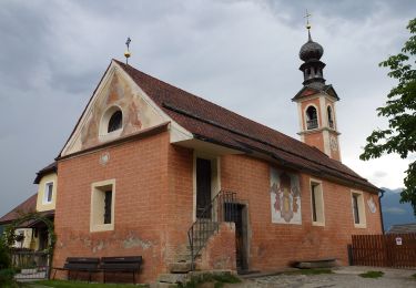
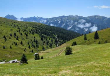
Ruta Senderismo de 12,4 km a descubrir en Trentino-Alto Adigio, Bolzano - Bozen, Lüsen - Luson. Esta ruta ha sido propuesta por VacheKiri67.
Descripción
Faite le 17/07/2024.
D'après "Wandern in Südtirol : Eisacktal, das Tal der Wege - 15 Hohmoorweg-Wanderung auf der Lüsner Alm". Durée indiquée pour le circuit : 3h30. Parking payant au Gasthof Tulper.
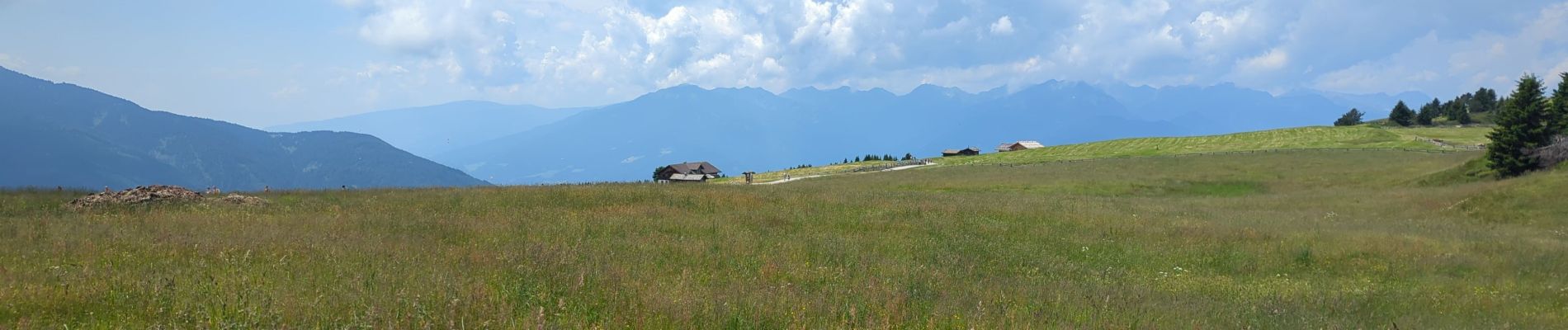
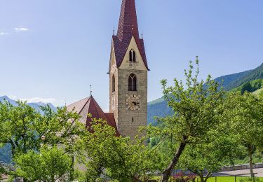
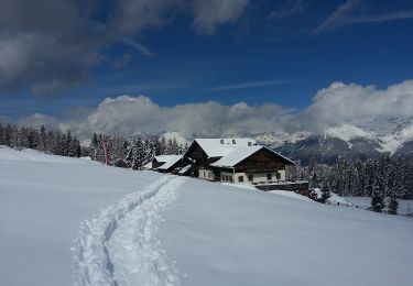
Localización
País:
Italy
Región :
Trentino-Alto Adigio
Departamento/provincia :
Bolzano - Bozen
Municipio :
Lüsen - Luson
Localidad:
Unknown
Salida:(Dec)
Salida:(UTM)
710299 ; 5182586 (32T) N.
Comentarios
Excursiones cerca
![Excursión A pie Lüsen - Luson - Panoramaweg - Photo](https://media.geolcdn.com/t/375/260/98e6eae6-9f33-4233-a38f-215ddc16a805.jpeg&format=jpg&maxdim=2)
![A pie A pie](https://static1.geolcdn.com/sitytour/trail-icons/100.png)
Panoramaweg
A pie
Fácil
Lüsen - Luson,
Trentino-Alto Adigio,
Bolzano - Bozen,
Italy
![](/images/other/stat-length.png)
3,1 km | 6 km-effort
1h 21min
![](https://static1.geolcdn.com/siteimages/upload/files/16400158638029165_repeat_loop_refresh_sync_direction_icon.png)
No
![Excursión A pie Lüsen - Luson - Wanderweg 3b - Lüsen - Photo](https://media.geolcdn.com/t/375/260/98e6eae6-9f33-4233-a38f-215ddc16a805.jpeg&format=jpg&maxdim=2)
![A pie A pie](https://static1.geolcdn.com/sitytour/trail-icons/100.png)
Wanderweg 3b - Lüsen
A pie
Fácil
Lüsen - Luson,
Trentino-Alto Adigio,
Bolzano - Bozen,
Italy
![](/images/other/stat-length.png)
3,7 km | 10,4 km-effort
2h 22min
![](https://static1.geolcdn.com/siteimages/upload/files/16400158638029165_repeat_loop_refresh_sync_direction_icon.png)
No
![Excursión A pie Rodeneck - Rodengo - Wanderroute 68 - Photo](https://media.geolcdn.com/t/375/260/34e9c99b-2ba6-41db-a7bc-8b504f1938d4.jpeg&format=jpg&maxdim=2)
![A pie A pie](https://static1.geolcdn.com/sitytour/trail-icons/100.png)
Wanderroute 68
A pie
Fácil
Rodeneck - Rodengo,
Trentino-Alto Adigio,
Bolzano - Bozen,
Italy
![](/images/other/stat-length.png)
9,3 km | 13,7 km-effort
3h 6min
![](https://static1.geolcdn.com/siteimages/upload/files/16400158638029165_repeat_loop_refresh_sync_direction_icon.png)
No
![Excursión A pie St. Lorenzen - San Lorenzo di Sebato - Wanderroute 67 - Photo](https://media.geolcdn.com/t/375/260/f7846c4c-abcd-4057-983b-fc1896884cc8.jpeg&format=jpg&maxdim=2)
![A pie A pie](https://static1.geolcdn.com/sitytour/trail-icons/100.png)
Wanderroute 67
A pie
Fácil
St. Lorenzen - San Lorenzo di Sebato,
Trentino-Alto Adigio,
Bolzano - Bozen,
Italy
![](/images/other/stat-length.png)
10,1 km | 14,9 km-effort
3h 23min
![](https://static1.geolcdn.com/siteimages/upload/files/16400158638029165_repeat_loop_refresh_sync_direction_icon.png)
No
![Excursión A pie Rodeneck - Rodengo - IT-4 - Photo](https://media.geolcdn.com/t/375/260/aa769cfd-1240-4b70-9616-a3b6f423f3b5.jpeg&format=jpg&maxdim=2)
![A pie A pie](https://static1.geolcdn.com/sitytour/trail-icons/100.png)
IT-4
A pie
Medio
Rodeneck - Rodengo,
Trentino-Alto Adigio,
Bolzano - Bozen,
Italy
![](/images/other/stat-length.png)
15,8 km | 24 km-effort
5h 25min
![](https://static1.geolcdn.com/siteimages/upload/files/16400158638029165_repeat_loop_refresh_sync_direction_icon.png)
No
![Excursión A pie Lüsen - Luson - IT-1 - Photo](https://media.geolcdn.com/t/375/260/796cd8a5-765b-46ce-b8a7-863d644cdf09.jpeg&format=jpg&maxdim=2)
![A pie A pie](https://static1.geolcdn.com/sitytour/trail-icons/100.png)
IT-1
A pie
Fácil
Lüsen - Luson,
Trentino-Alto Adigio,
Bolzano - Bozen,
Italy
![](/images/other/stat-length.png)
9,1 km | 17 km-effort
3h 51min
![](https://static1.geolcdn.com/siteimages/upload/files/16400158638029165_repeat_loop_refresh_sync_direction_icon.png)
No
![Excursión A pie Lüsen - Luson - IT-2 - Photo](https://media.geolcdn.com/t/375/260/e6b1b829-6a2f-468d-aeb9-0b707a1d9e2e.jpeg&format=jpg&maxdim=2)
![A pie A pie](https://static1.geolcdn.com/sitytour/trail-icons/100.png)
IT-2
A pie
Fácil
Lüsen - Luson,
Trentino-Alto Adigio,
Bolzano - Bozen,
Italy
![](/images/other/stat-length.png)
10,6 km | 18,7 km-effort
4h 14min
![](https://static1.geolcdn.com/siteimages/upload/files/16400158638029165_repeat_loop_refresh_sync_direction_icon.png)
No
![Excursión Senderismo Lüsen - Luson - Lüsner Alm - Sommet du Campill - Photo](https://media.geolcdn.com/t/375/260/4e1953fb-b50a-4fca-85d5-0eb9ec465125.jpg&format=jpg&maxdim=2)
![Senderismo Senderismo](https://static1.geolcdn.com/sitytour/trail-icons/101.png)
Lüsner Alm - Sommet du Campill
Senderismo
Medio
Lüsen - Luson,
Trentino-Alto Adigio,
Bolzano - Bozen,
Italy
![](/images/other/stat-length.png)
10,5 km | 17,4 km-effort
5h 13min
![](https://static1.geolcdn.com/siteimages/upload/files/16400158638029165_repeat_loop_refresh_sync_direction_icon.png)
Sí
![Excursión A pie Kiens - Chienes - Wanderroute 15 - Photo](https://media.geolcdn.com/t/375/260/82ef480e-999c-44dd-a188-2df32b2e9f38.jpeg&format=jpg&maxdim=2)
![A pie A pie](https://static1.geolcdn.com/sitytour/trail-icons/100.png)
Wanderroute 15
A pie
Fácil
Kiens - Chienes,
Trentino-Alto Adigio,
Bolzano - Bozen,
Italy
![](/images/other/stat-length.png)
3 km | 4,3 km-effort
58min
![](https://static1.geolcdn.com/siteimages/upload/files/16400158638029165_repeat_loop_refresh_sync_direction_icon.png)
No