![](/images/other/stat-length.png)
![Excursión Saâcy-sur-Marne - 2024-07-01_18h09m53_sitytrail-le-chemin-de-st-colomban-en-idf-etape-2-nanteuil-jouarre.gpx (1) - Photo](https://media.geolcdn.com/t/1900/400/ext.pjpeg?maxdim=2&url=https%3A%2F%2Fsecurestorage.geolives.com%2Fsitytour%2Ftrail-bg%2Fdefault.jpg)
2024-07-01_18h09m53_sitytrail-le-chemin-de-st-colomban-en-idf-etape-2-nanteuil-jouarre.gpx (1)
taran
Usuario
![Longitud](/images/other/stat-length.png)
Longitud
24 km
![Altitud máxima](https://static1.geolcdn.com/siteimages/upload/files/1508320355ic_sort_altitude_max_24dp.png)
Altitud máxima
186 m
![Desnivel positivo](https://static1.geolcdn.com/siteimages/upload/files/1508320355ic_sort_den_pos_24dp.png)
Desnivel positivo
493 m
![Km-Effort](/images/other/stat-length.png)
Km-Effort
31 km
![Altitud mínima](https://static1.geolcdn.com/siteimages/upload/files/1508320355ic_sort_altitude_min_24dp.png)
Altitud mínima
50 m
![Desnivel negativo](https://static1.geolcdn.com/siteimages/upload/files/1508320355ic_sort_den_neg_24dp.png)
Desnivel negativo
411 m
![Boucle](https://static1.geolcdn.com/siteimages/upload/files/16400158638029165_repeat_loop_refresh_sync_direction_icon.png)
Boucle
No
Fecha de creación :
2024-07-01 16:09:56.107
Última modificación :
2024-07-01 16:09:59.072
![Escanee este código QR para abrir la excursión en la aplicación SityTrail](https://capi.geolives.com/qq0zvz2zws4bq2lad0pu/sitytour/trails/4108732/qr.png?size=200)
Aplicación GPS de excursión GRATIS
A propósito
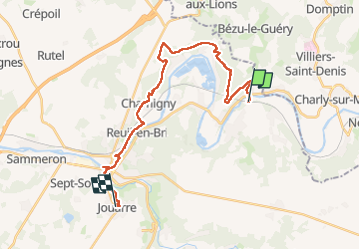
Ruta de 24 km a descubrir en Isla de Francia, Sena y Marne, Saâcy-sur-Marne. Esta ruta ha sido propuesta por taran.
Descripción
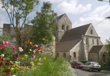
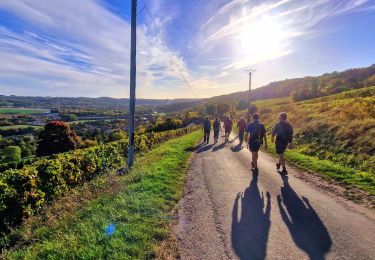
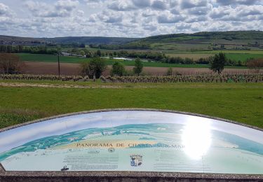
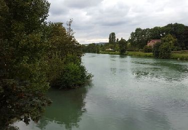
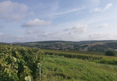
Une seconde étape plus facile que la précédente avec néanmoins une grande partie en sous bois et beaucoup de boue dans la matinée . Après midi agréable avec bcp plus de culturel
Localización
País:
France
Región :
Isla de Francia
Departamento/provincia :
Sena y Marne
Municipio :
Saâcy-sur-Marne
Localidad:
Unknown
Salida:(Dec)
Salida:(UTM)
516122 ; 5424590 (31U) N.
Comentarios
Excursiones cerca
![Excursión sport Saâcy-sur-Marne - nanteuil-saacy-pavant-charly-marne-crouttes-boucle-27-km - Photo](https://media.geolcdn.com/t/375/260/ext.jpg?maxdim=2&url=https%3A%2F%2Fsecurestorage.geolives.com%2Fsitytour%2Ftrail-bg%2Fdefault.jpg)
nanteuil-saacy-pavant-charly-marne-crouttes-boucle-27-km
sport
Muy fácil
(1)
Saâcy-sur-Marne,
Isla de Francia,
Sena y Marne,
France
![](/images/other/stat-length.png)
28 km | 35 km-effort
Desconocido
![](https://static1.geolcdn.com/siteimages/upload/files/16400158638029165_repeat_loop_refresh_sync_direction_icon.png)
Sí
![Excursión Senderismo Charly-sur-Marne - Entre ciel et vignes - Photo](https://media.geolcdn.com/t/375/260/ext.jpg?maxdim=2&url=https%3A%2F%2Fservices.sitytrail.com%2FGeolivesWS%2FDownloadMedia.ashx%3FTrailID%3D108344%26Media%3D1015_2.jpg)
![Senderismo Senderismo](https://static1.geolcdn.com/sitytour/trail-icons/101.png)
Entre ciel et vignes
Senderismo
Muy difícil
(2)
Charly-sur-Marne,
Alta Francia,
Aisne,
France
![](/images/other/stat-length.png)
16,3 km | 19,7 km-effort
4h 0min
![](https://static1.geolcdn.com/siteimages/upload/files/16400158638029165_repeat_loop_refresh_sync_direction_icon.png)
Sí
![Excursión Senderismo Saâcy-sur-Marne - Le chemin de St Colomban en IDF ETAPE 2 Nanteuil -Jouarre - Photo](https://media.geolcdn.com/t/375/260/59b477ec-13ad-4f42-b3b4-8f7ce78d2d7b.jpg&format=jpg&maxdim=2)
![Senderismo Senderismo](https://static1.geolcdn.com/sitytour/trail-icons/101.png)
Le chemin de St Colomban en IDF ETAPE 2 Nanteuil -Jouarre
Senderismo
Medio
Saâcy-sur-Marne,
Isla de Francia,
Sena y Marne,
France
![](/images/other/stat-length.png)
24 km | 31 km-effort
5h 31min
![](https://static1.geolcdn.com/siteimages/upload/files/16400158638029165_repeat_loop_refresh_sync_direction_icon.png)
No
![Excursión Senderismo Saâcy-sur-Marne - Boucle Nanteuil Saacy - Charly sur Marne - Photo](https://media.geolcdn.com/t/375/260/14104ec2-2071-4530-9ea3-14b10ca4b8c0.jpg&format=jpg&maxdim=2)
![Senderismo Senderismo](https://static1.geolcdn.com/sitytour/trail-icons/101.png)
Boucle Nanteuil Saacy - Charly sur Marne
Senderismo
Medio
Saâcy-sur-Marne,
Isla de Francia,
Sena y Marne,
France
![](/images/other/stat-length.png)
31 km | 40 km-effort
6h 25min
![](https://static1.geolcdn.com/siteimages/upload/files/16400158638029165_repeat_loop_refresh_sync_direction_icon.png)
Sí
![Excursión Senderismo Crouttes-sur-Marne - Crouttes-sur Marne du 20/05/2021 - Photo](https://media.geolcdn.com/t/375/260/7f54f421-be26-4aa7-983d-984ba58ca643.jpg&format=jpg&maxdim=2)
![Senderismo Senderismo](https://static1.geolcdn.com/sitytour/trail-icons/101.png)
Crouttes-sur Marne du 20/05/2021
Senderismo
Difícil
Crouttes-sur-Marne,
Alta Francia,
Aisne,
France
![](/images/other/stat-length.png)
12 km | 14,8 km-effort
4h 9min
![](https://static1.geolcdn.com/siteimages/upload/files/16400158638029165_repeat_loop_refresh_sync_direction_icon.png)
Sí
![Excursión Senderismo Saâcy-sur-Marne - NANTEUIL RANDO NOIX 13 KM - Photo](https://media.geolcdn.com/t/375/260/ext.jpg?maxdim=2&url=https%3A%2F%2Fstatic1.geolcdn.com%2Fsiteimages%2Fupload%2Ffiles%2F1553511878bg_sport_marche.png)
![Senderismo Senderismo](https://static1.geolcdn.com/sitytour/trail-icons/101.png)
NANTEUIL RANDO NOIX 13 KM
Senderismo
Difícil
(1)
Saâcy-sur-Marne,
Isla de Francia,
Sena y Marne,
France
![](/images/other/stat-length.png)
13 km | 16,7 km-effort
3h 47min
![](https://static1.geolcdn.com/siteimages/upload/files/16400158638029165_repeat_loop_refresh_sync_direction_icon.png)
Sí
![Excursión Senderismo Saâcy-sur-Marne - CRAB : la Dhuys pétillante - Photo](https://media.geolcdn.com/t/375/260/ext.jpg?maxdim=2&url=https%3A%2F%2Fservices.sitytrail.com%2FGeolivesWS%2FDownloadMedia.ashx%3FTrailID%3D629705%26Media%3Dfix__20160911143405.jpg)
![Senderismo Senderismo](https://static1.geolcdn.com/sitytour/trail-icons/101.png)
CRAB : la Dhuys pétillante
Senderismo
Fácil
Saâcy-sur-Marne,
Isla de Francia,
Sena y Marne,
France
![](/images/other/stat-length.png)
23 km | 28 km-effort
6h 0min
![](https://static1.geolcdn.com/siteimages/upload/files/16400158638029165_repeat_loop_refresh_sync_direction_icon.png)
Sí
![Excursión Senderismo Saâcy-sur-Marne - Rando 28 km Nanteuil à Chateau Thierry - Photo](https://media.geolcdn.com/t/375/260/ext.jpg?maxdim=2&url=https%3A%2F%2Fstatic1.geolcdn.com%2Fsiteimages%2Fupload%2Ffiles%2F1553511878bg_sport_marche.png)
![Senderismo Senderismo](https://static1.geolcdn.com/sitytour/trail-icons/101.png)
Rando 28 km Nanteuil à Chateau Thierry
Senderismo
Fácil
(1)
Saâcy-sur-Marne,
Isla de Francia,
Sena y Marne,
France
![](/images/other/stat-length.png)
26 km | 33 km-effort
7h 2min
![](https://static1.geolcdn.com/siteimages/upload/files/16400158638029165_repeat_loop_refresh_sync_direction_icon.png)
No
![Excursión Senderismo Saâcy-sur-Marne - 20240910 rando - Photo](https://media.geolcdn.com/t/375/260/4ce090ba-1113-414a-ae5a-25da81a4306c.jpg&format=jpg&maxdim=2)
![Senderismo Senderismo](https://static1.geolcdn.com/sitytour/trail-icons/101.png)
20240910 rando
Senderismo
Difícil
Saâcy-sur-Marne,
Isla de Francia,
Sena y Marne,
France
![](/images/other/stat-length.png)
11,1 km | 14,5 km-effort
3h 17min
![](https://static1.geolcdn.com/siteimages/upload/files/16400158638029165_repeat_loop_refresh_sync_direction_icon.png)
No