![](/images/other/stat-length.png)
![Excursión Senderismo Durfort-Lacapelette - St Jacques Étape 21 - Photo](https://media.geolcdn.com/t/1900/400/ext.pjpeg?maxdim=2&url=https%3A%2F%2Fstatic1.geolcdn.com%2Fsiteimages%2Fupload%2Ffiles%2F1553511878bg_sport_marche.png)
St Jacques Étape 21
Jean-MarieFaux
Usuario
![Longitud](/images/other/stat-length.png)
Longitud
15,6 km
![Altitud máxima](https://static1.geolcdn.com/siteimages/upload/files/1508320355ic_sort_altitude_max_24dp.png)
Altitud máxima
194 m
![Desnivel positivo](https://static1.geolcdn.com/siteimages/upload/files/1508320355ic_sort_den_pos_24dp.png)
Desnivel positivo
188 m
![Km-Effort](/images/other/stat-length.png)
Km-Effort
18,5 km
![Altitud mínima](https://static1.geolcdn.com/siteimages/upload/files/1508320355ic_sort_altitude_min_24dp.png)
Altitud mínima
72 m
![Desnivel negativo](https://static1.geolcdn.com/siteimages/upload/files/1508320355ic_sort_den_neg_24dp.png)
Desnivel negativo
305 m
![Boucle](https://static1.geolcdn.com/siteimages/upload/files/16400158638029165_repeat_loop_refresh_sync_direction_icon.png)
Boucle
No
Fecha de creación :
2016-01-23 00:00:00.0
Última modificación :
2016-01-23 00:00:00.0
![Senderismo](https://static1.geolcdn.com/sitytour/trail-icons/101.png)
4h07
Dificultad : Muy fácil
![Escanee este código QR para abrir la excursión en la aplicación SityTrail](https://capi.geolives.com/qq0zvz2zws4bq2lad0pu/sitytour/trails/410872/qr.png?size=200)
Aplicación GPS de excursión GRATIS
A propósito
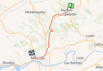
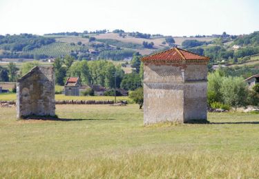
Ruta Senderismo de 15,6 km a descubrir en Occitania, Tarn y Garona, Durfort-Lacapelette. Esta ruta ha sido propuesta por Jean-MarieFaux.
Descripción
Durfort La Capeleette Moissac. Étape courte pour prendre le temps de visiter Moissac
Localización
País:
France
Región :
Occitania
Departamento/provincia :
Tarn y Garona
Municipio :
Durfort-Lacapelette
Localidad:
Unknown
Salida:(Dec)
Salida:(UTM)
352490 ; 4894138 (31T) N.
Comentarios
Excursiones cerca
![Excursión Senderismo Durfort-Lacapelette - Mon Compostelle neuvième étape - Photo](https://media.geolcdn.com/t/375/260/ext.jpg?maxdim=2&url=https%3A%2F%2Fservices.sitytrail.com%2FGeolivesWS%2FDownloadMedia.ashx%3FTrailID%3D684076%26Media%3Dcf9f196a-5b71-43f7-b867-ea4ea4fb3350.JPG)
![Senderismo Senderismo](https://static1.geolcdn.com/sitytour/trail-icons/101.png)
Mon Compostelle neuvième étape
Senderismo
Difícil
Durfort-Lacapelette,
Occitania,
Tarn y Garona,
France
![](/images/other/stat-length.png)
49 km | 58 km-effort
10h 20min
![](https://static1.geolcdn.com/siteimages/upload/files/16400158638029165_repeat_loop_refresh_sync_direction_icon.png)
No
![Excursión Senderismo Durfort-Lacapelette - St Martin - Bouillan - Chemin de Compostelle - Photo](https://media.geolcdn.com/t/375/260/ext.jpg?maxdim=2&url=https%3A%2F%2Fservices.sitytrail.com%2FGeolivesWS%2FDownloadMedia.ashx%3FTrailID%3D109582%26Media%3D4205_5.jpg)
![Senderismo Senderismo](https://static1.geolcdn.com/sitytour/trail-icons/101.png)
St Martin - Bouillan - Chemin de Compostelle
Senderismo
Muy difícil
Durfort-Lacapelette,
Occitania,
Tarn y Garona,
France
![](/images/other/stat-length.png)
26 km | 30 km-effort
10h 0min
![](https://static1.geolcdn.com/siteimages/upload/files/16400158638029165_repeat_loop_refresh_sync_direction_icon.png)
No
![Excursión Senderismo Durfort-Lacapelette - Compostelle Durfort a Espalais - Photo](https://media.geolcdn.com/t/375/260/ext.jpg?maxdim=2&url=https%3A%2F%2Fstatic1.geolcdn.com%2Fsiteimages%2Fupload%2Ffiles%2F1553511878bg_sport_marche.png)
![Senderismo Senderismo](https://static1.geolcdn.com/sitytour/trail-icons/101.png)
Compostelle Durfort a Espalais
Senderismo
Medio
Durfort-Lacapelette,
Occitania,
Tarn y Garona,
France
![](/images/other/stat-length.png)
46 km | 53 km-effort
7h 56min
![](https://static1.geolcdn.com/siteimages/upload/files/16400158638029165_repeat_loop_refresh_sync_direction_icon.png)
No
![Excursión Senderismo Durfort-Lacapelette - SityTrail - CC_Velay_EA_17_Lauzerte_Moissac_20080817 - Photo](https://media.geolcdn.com/t/375/260/ext.jpg?maxdim=2&url=https%3A%2F%2Fstatic1.geolcdn.com%2Fsiteimages%2Fupload%2Ffiles%2F1553511878bg_sport_marche.png)
![Senderismo Senderismo](https://static1.geolcdn.com/sitytour/trail-icons/101.png)
SityTrail - CC_Velay_EA_17_Lauzerte_Moissac_20080817
Senderismo
Muy difícil
(1)
Durfort-Lacapelette,
Occitania,
Tarn y Garona,
France
![](/images/other/stat-length.png)
14,8 km | 18,1 km-effort
7h 35min
![](https://static1.geolcdn.com/siteimages/upload/files/16400158638029165_repeat_loop_refresh_sync_direction_icon.png)
No
![Excursión Senderismo Durfort-Lacapelette - Etape Durfort-Lacapelette à Moissac - Photo](https://media.geolcdn.com/t/375/260/ext.jpg?maxdim=2&url=https%3A%2F%2Fstatic1.geolcdn.com%2Fsiteimages%2Fupload%2Ffiles%2F1553511878bg_sport_marche.png)
![Senderismo Senderismo](https://static1.geolcdn.com/sitytour/trail-icons/101.png)
Etape Durfort-Lacapelette à Moissac
Senderismo
Fácil
Durfort-Lacapelette,
Occitania,
Tarn y Garona,
France
![](/images/other/stat-length.png)
16,2 km | 21 km-effort
4h 22min
![](https://static1.geolcdn.com/siteimages/upload/files/16400158638029165_repeat_loop_refresh_sync_direction_icon.png)
No
![Excursión Senderismo Durfort-Lacapelette - Compostelle 19 - Durfort-Lacapelette -> Moissac - Photo](https://media.geolcdn.com/t/375/260/ext.jpg?maxdim=2&url=https%3A%2F%2Fstatic1.geolcdn.com%2Fsiteimages%2Fupload%2Ffiles%2F1553511878bg_sport_marche.png)
![Senderismo Senderismo](https://static1.geolcdn.com/sitytour/trail-icons/101.png)
Compostelle 19 - Durfort-Lacapelette -> Moissac
Senderismo
Muy fácil
Durfort-Lacapelette,
Occitania,
Tarn y Garona,
France
![](/images/other/stat-length.png)
17,8 km | 22 km-effort
4h 38min
![](https://static1.geolcdn.com/siteimages/upload/files/16400158638029165_repeat_loop_refresh_sync_direction_icon.png)
No
![Excursión Marcha nórdica Durfort-Lacapelette - De St Martin à Moissac - Photo](https://media.geolcdn.com/t/375/260/ext.jpg?maxdim=2&url=https%3A%2F%2Fstatic1.geolcdn.com%2Fsiteimages%2Fupload%2Ffiles%2F1545311037marcheuse_200dpi.jpg)
![Marcha nórdica Marcha nórdica](https://static1.geolcdn.com/sitytour/trail-icons/102.png)
De St Martin à Moissac
Marcha nórdica
Medio
Durfort-Lacapelette,
Occitania,
Tarn y Garona,
France
![](/images/other/stat-length.png)
14,3 km | 18,5 km-effort
4h 44min
![](https://static1.geolcdn.com/siteimages/upload/files/16400158638029165_repeat_loop_refresh_sync_direction_icon.png)
No
![Excursión Senderismo Lauzerte - La garde Haute- Landou par GR65 puisD57 à drte vers le Moulinal D81 crt D16 puis peyrounels - Photo](https://media.geolcdn.com/t/375/260/ext.jpg?maxdim=2&url=https%3A%2F%2Fstatic1.geolcdn.com%2Fsiteimages%2Fupload%2Ffiles%2F1553511878bg_sport_marche.png)
![Senderismo Senderismo](https://static1.geolcdn.com/sitytour/trail-icons/101.png)
La garde Haute- Landou par GR65 puisD57 à drte vers le Moulinal D81 crt D16 p...
Senderismo
Fácil
Lauzerte,
Occitania,
Tarn y Garona,
France
![](/images/other/stat-length.png)
3,5 km | 5 km-effort
1h 8min
![](https://static1.geolcdn.com/siteimages/upload/files/16400158638029165_repeat_loop_refresh_sync_direction_icon.png)
No
![Excursión Senderismo Cazes-Mondenard - cazes mondenard PR2 le rey - Photo](https://media.geolcdn.com/t/375/260/ext.jpg?maxdim=2&url=https%3A%2F%2Fstatic1.geolcdn.com%2Fsiteimages%2Fupload%2Ffiles%2F1553511878bg_sport_marche.png)
![Senderismo Senderismo](https://static1.geolcdn.com/sitytour/trail-icons/101.png)
cazes mondenard PR2 le rey
Senderismo
Medio
Cazes-Mondenard,
Occitania,
Tarn y Garona,
France
![](/images/other/stat-length.png)
9,9 km | 13,4 km-effort
3h 12min
![](https://static1.geolcdn.com/siteimages/upload/files/16400158638029165_repeat_loop_refresh_sync_direction_icon.png)
Sí