![](/images/other/stat-length.png)
![Excursión Senderismo La Souche - Bauzon station- Méjean-plateau du grand Tanargue - Photo](https://media.geolcdn.com/t/1900/400/5666ce05-8e4a-41c4-aef3-79754851f3b9.jpg&format=pjpeg&maxdim=2)
Bauzon station- Méjean-plateau du grand Tanargue
coureursdecretes
Usuario
![Longitud](/images/other/stat-length.png)
Longitud
16,9 km
![Altitud máxima](https://static1.geolcdn.com/siteimages/upload/files/1508320355ic_sort_altitude_max_24dp.png)
Altitud máxima
1507 m
![Desnivel positivo](https://static1.geolcdn.com/siteimages/upload/files/1508320355ic_sort_den_pos_24dp.png)
Desnivel positivo
376 m
![Km-Effort](/images/other/stat-length.png)
Km-Effort
22 km
![Altitud mínima](https://static1.geolcdn.com/siteimages/upload/files/1508320355ic_sort_altitude_min_24dp.png)
Altitud mínima
1361 m
![Desnivel negativo](https://static1.geolcdn.com/siteimages/upload/files/1508320355ic_sort_den_neg_24dp.png)
Desnivel negativo
376 m
![Boucle](https://static1.geolcdn.com/siteimages/upload/files/16400158638029165_repeat_loop_refresh_sync_direction_icon.png)
Boucle
Sí
Fecha de creación :
2024-07-01 07:45:16.574
Última modificación :
2024-08-16 15:11:32.328
![Senderismo](https://static1.geolcdn.com/sitytour/trail-icons/101.png)
4h58
Dificultad : Muy difícil
![Escanee este código QR para abrir la excursión en la aplicación SityTrail](https://capi.geolives.com/qq0zvz2zws4bq2lad0pu/sitytour/trails/4108400/qr.png?size=200)
Aplicación GPS de excursión GRATIS
A propósito
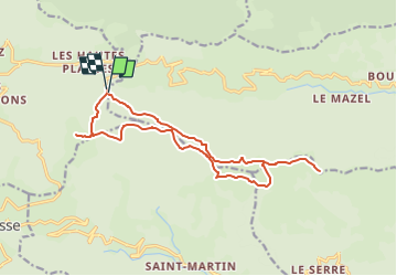
Ruta Senderismo de 16,9 km a descubrir en Auvergne-Rhône-Alpes, Ardecha, La Souche. Esta ruta ha sido propuesta por coureursdecretes.
Descripción
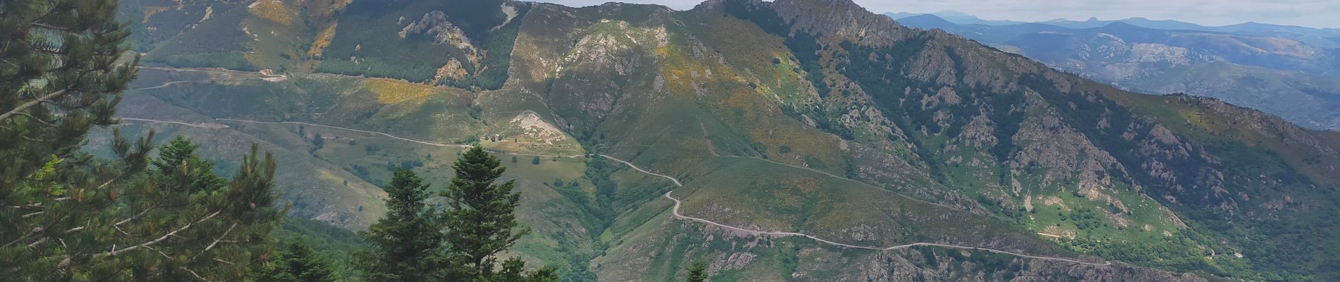
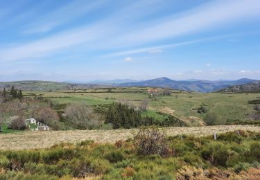
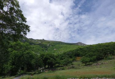
Une randonnée sur la partie la plus élevée du Tanargue. Panorama sur les crêtes, alpages, parcours didactique...peu de dénivelé, sentiers très praticables.
Localización
País:
France
Región :
Auvergne-Rhône-Alpes
Departamento/provincia :
Ardecha
Municipio :
La Souche
Localidad:
Unknown
Salida:(Dec)
Salida:(UTM)
586419 ; 4942361 (31T) N.
Comentarios
Excursiones cerca
![Excursión Senderismo Mayres - 07 rocher d abraham - Photo](https://media.geolcdn.com/t/375/260/ext.jpg?maxdim=2&url=https%3A%2F%2Fstatic1.geolcdn.com%2Fsiteimages%2Fupload%2Ffiles%2F1553511878bg_sport_marche.png)
![Senderismo Senderismo](https://static1.geolcdn.com/sitytour/trail-icons/101.png)
07 rocher d abraham
Senderismo
Medio
(2)
Mayres,
Auvergne-Rhône-Alpes,
Ardecha,
France
![](/images/other/stat-length.png)
14 km | 28 km-effort
8h 4min
![](https://static1.geolcdn.com/siteimages/upload/files/16400158638029165_repeat_loop_refresh_sync_direction_icon.png)
Sí
![Excursión Senderismo Borne - croix de beauzon - Photo](https://media.geolcdn.com/t/375/260/217677dd-c155-48af-bc87-419b5b32c8ce.jpg&format=jpg&maxdim=2)
![Senderismo Senderismo](https://static1.geolcdn.com/sitytour/trail-icons/101.png)
croix de beauzon
Senderismo
Difícil
Borne,
Auvergne-Rhône-Alpes,
Ardecha,
France
![](/images/other/stat-length.png)
13,6 km | 18,2 km-effort
5h 53min
![](https://static1.geolcdn.com/siteimages/upload/files/16400158638029165_repeat_loop_refresh_sync_direction_icon.png)
Sí
![Excursión Senderismo Mayres - Mayres Chaumiène 12km - Photo](https://media.geolcdn.com/t/375/260/a133b020-a8a4-4863-bdb6-488ddda17997.jpg&format=jpg&maxdim=2)
![Senderismo Senderismo](https://static1.geolcdn.com/sitytour/trail-icons/101.png)
Mayres Chaumiène 12km
Senderismo
Difícil
Mayres,
Auvergne-Rhône-Alpes,
Ardecha,
France
![](/images/other/stat-length.png)
12,2 km | 23 km-effort
6h 43min
![](https://static1.geolcdn.com/siteimages/upload/files/16400158638029165_repeat_loop_refresh_sync_direction_icon.png)
Sí
![Excursión Senderismo Valgorge - Le Tanargue - Photo](https://media.geolcdn.com/t/375/260/ad0e721e-bf17-4b50-b28e-4b195a037c98.jpg&format=jpg&maxdim=2)
![Senderismo Senderismo](https://static1.geolcdn.com/sitytour/trail-icons/101.png)
Le Tanargue
Senderismo
Difícil
Valgorge,
Auvergne-Rhône-Alpes,
Ardecha,
France
![](/images/other/stat-length.png)
13,7 km | 24 km-effort
5h 28min
![](https://static1.geolcdn.com/siteimages/upload/files/16400158638029165_repeat_loop_refresh_sync_direction_icon.png)
Sí
![Excursión Senderismo Loubaresse - Loubaresse ruisseau de goutelles 10 km - Photo](https://media.geolcdn.com/t/375/260/7fb7aff1-6923-41f8-900d-5aa3bb3bfe91.jpg&format=jpg&maxdim=2)
![Senderismo Senderismo](https://static1.geolcdn.com/sitytour/trail-icons/101.png)
Loubaresse ruisseau de goutelles 10 km
Senderismo
Medio
Loubaresse,
Auvergne-Rhône-Alpes,
Ardecha,
France
![](/images/other/stat-length.png)
10 km | 13,3 km-effort
2h 55min
![](https://static1.geolcdn.com/siteimages/upload/files/16400158638029165_repeat_loop_refresh_sync_direction_icon.png)
Sí
![Excursión Senderismo Loubaresse - Loubaresse Nord 5,2 km - Photo](https://media.geolcdn.com/t/375/260/5ae50d28-b170-4d44-aab5-94560c77c18b.jpg&format=jpg&maxdim=2)
![Senderismo Senderismo](https://static1.geolcdn.com/sitytour/trail-icons/101.png)
Loubaresse Nord 5,2 km
Senderismo
Medio
Loubaresse,
Auvergne-Rhône-Alpes,
Ardecha,
France
![](/images/other/stat-length.png)
5,2 km | 8,6 km-effort
2h 12min
![](https://static1.geolcdn.com/siteimages/upload/files/16400158638029165_repeat_loop_refresh_sync_direction_icon.png)
Sí
![Excursión Senderismo Borne - 2023-01-26_14h31m24_Station Croix de Bauzon 14 km.gpx.xml - Photo](https://media.geolcdn.com/t/375/260/186f655e-2b32-453c-b04b-facbcec1469b.jpg&format=jpg&maxdim=2)
![Senderismo Senderismo](https://static1.geolcdn.com/sitytour/trail-icons/101.png)
2023-01-26_14h31m24_Station Croix de Bauzon 14 km.gpx.xml
Senderismo
Difícil
Borne,
Auvergne-Rhône-Alpes,
Ardecha,
France
![](/images/other/stat-length.png)
13,9 km | 19,2 km-effort
4h 22min
![](https://static1.geolcdn.com/siteimages/upload/files/16400158638029165_repeat_loop_refresh_sync_direction_icon.png)
Sí
![Excursión A pie Mayres - Tour des Poignets 18km - Photo](https://media.geolcdn.com/t/375/260/4695ff56-51f7-439d-a787-0d719ef81c46.jpg&format=jpg&maxdim=2)
![A pie A pie](https://static1.geolcdn.com/sitytour/trail-icons/100.png)
Tour des Poignets 18km
A pie
Medio
Mayres,
Auvergne-Rhône-Alpes,
Ardecha,
France
![](/images/other/stat-length.png)
17,1 km | 25 km-effort
5h 42min
![](https://static1.geolcdn.com/siteimages/upload/files/16400158638029165_repeat_loop_refresh_sync_direction_icon.png)
Sí
![Excursión Senderismo Saint-Étienne-de-Lugdarès - Le Bez-Borne-les Chambons - Photo](https://media.geolcdn.com/t/375/260/84516e8e-4390-46d3-bf0d-44f54607fcbb.jpg&format=jpg&maxdim=2)
![Senderismo Senderismo](https://static1.geolcdn.com/sitytour/trail-icons/101.png)
Le Bez-Borne-les Chambons
Senderismo
Difícil
Saint-Étienne-de-Lugdarès,
Auvergne-Rhône-Alpes,
Ardecha,
France
![](/images/other/stat-length.png)
14,1 km | 22 km-effort
5h 20min
![](https://static1.geolcdn.com/siteimages/upload/files/16400158638029165_repeat_loop_refresh_sync_direction_icon.png)
Sí