![](/images/other/stat-length.png)
![Excursión Senderismo Ostheim - Le long de la rivière Fecht à Ostheim en France - Photo](https://media.geolcdn.com/t/1900/400/e49f18ff-da2a-44e2-88bc-a804e5f08011.jpeg&format=pjpeg&maxdim=2)
Le long de la rivière Fecht à Ostheim en France
Benjamin27
Usuario GUIDE
![Longitud](/images/other/stat-length.png)
![Altitud máxima](https://static1.geolcdn.com/siteimages/upload/files/1508320355ic_sort_altitude_max_24dp.png)
![Desnivel positivo](https://static1.geolcdn.com/siteimages/upload/files/1508320355ic_sort_den_pos_24dp.png)
![Km-Effort](/images/other/stat-length.png)
![Altitud mínima](https://static1.geolcdn.com/siteimages/upload/files/1508320355ic_sort_altitude_min_24dp.png)
![Desnivel negativo](https://static1.geolcdn.com/siteimages/upload/files/1508320355ic_sort_den_neg_24dp.png)
![Boucle](https://static1.geolcdn.com/siteimages/upload/files/16400158638029165_repeat_loop_refresh_sync_direction_icon.png)
![Senderismo](https://static1.geolcdn.com/sitytour/trail-icons/101.png)
33m
Dificultad : Fácil
![Escanee este código QR para abrir la excursión en la aplicación SityTrail](https://capi.geolives.com/qq0zvz2zws4bq2lad0pu/sitytour/trails/4107538/qr.png?size=200)
Aplicación GPS de excursión GRATIS
A propósito
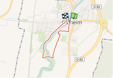
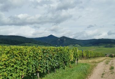
Ruta Senderismo de 2,3 km a descubrir en Gran Este, Alto Rin, Ostheim. Esta ruta ha sido propuesta por Benjamin27.
Descripción
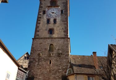
Le long de la Fecht, vous sillonnerez ce joli petit village. Vous aurez la chance également de voir des cigognes, levez les yeux!
👣 Distance : 2,4km - balisage logo cigogne bleue.
📍Départ : au niveau de l’église catholique, rue Albert Schweitzer à 68150 Ostheim.
Localización
Comentarios
Excursiones cerca
![Excursión Bici de montaña Ribeauvillé - Ribeauvillé Riquewihr - Photo](https://media.geolcdn.com/t/375/260/ext.jpg?maxdim=2&url=https%3A%2F%2Fservices.sitytrail.com%2FGeolivesWS%2FDownloadMedia.ashx%3FTrailID%3D101224%26Media%3D712_1.jpg)
![Bici de montaña Bici de montaña](https://static1.geolcdn.com/sitytour/trail-icons/202.png)
Bici de montaña
![](/images/other/stat-length.png)
![](https://static1.geolcdn.com/siteimages/upload/files/16400158638029165_repeat_loop_refresh_sync_direction_icon.png)
![Excursión Senderismo Hunawihr - Hunawihr - Riquewihr - Photo](https://media.geolcdn.com/t/375/260/ext.jpg?maxdim=2&url=https%3A%2F%2Fstatic1.geolcdn.com%2Fsiteimages%2Fupload%2Ffiles%2F1553511878bg_sport_marche.png)
![Senderismo Senderismo](https://static1.geolcdn.com/sitytour/trail-icons/101.png)
Senderismo
![](/images/other/stat-length.png)
![](https://static1.geolcdn.com/siteimages/upload/files/16400158638029165_repeat_loop_refresh_sync_direction_icon.png)
![Excursión Paseo ecuestre Kaysersberg-Vignoble - 000004 - Photo](https://media.geolcdn.com/t/375/260/fc80041c-b401-476e-a019-02f21cb51a95.jpg&format=jpg&maxdim=2)
![Paseo ecuestre Paseo ecuestre](https://static1.geolcdn.com/sitytour/trail-icons/301.png)
Paseo ecuestre
![](/images/other/stat-length.png)
![](https://static1.geolcdn.com/siteimages/upload/files/16400158638029165_repeat_loop_refresh_sync_direction_icon.png)
![Excursión Senderismo Riquewihr - Sentier des grands crus - Photo](https://media.geolcdn.com/t/375/260/ext.jpg?maxdim=2&url=https%3A%2F%2Fservices.sitytrail.com%2FGeolivesWS%2FDownloadMedia.ashx%3FTrailID%3D482185%26Media%3D8532cb29-bcf9-4719-bd1f-5f2e4165e237.jpg)
![Senderismo Senderismo](https://static1.geolcdn.com/sitytour/trail-icons/101.png)
Senderismo
![](/images/other/stat-length.png)
![](https://static1.geolcdn.com/siteimages/upload/files/16400158638029165_repeat_loop_refresh_sync_direction_icon.png)
![Excursión Senderismo Mittelwihr - Mittelwihr - Beblenheim - Zellenberg - Hunawihr - Riquewihr - Nécropole de Sigolsheim - Photo](https://media.geolcdn.com/t/375/260/270dee57-4c57-4155-999a-3cb2b93f05a0.jpg&format=jpg&maxdim=2)
![Senderismo Senderismo](https://static1.geolcdn.com/sitytour/trail-icons/101.png)
Senderismo
![](/images/other/stat-length.png)
![](https://static1.geolcdn.com/siteimages/upload/files/16400158638029165_repeat_loop_refresh_sync_direction_icon.png)
![Excursión Senderismo Mittelwihr - Mittelwihr - Nécropole de Sigolsheim - Riquewihr - Hunawihr - Zellenberg - Photo](https://media.geolcdn.com/t/375/260/10a16fa9-0020-48fe-b312-53bccae47e63.jpg&format=jpg&maxdim=2)
![Senderismo Senderismo](https://static1.geolcdn.com/sitytour/trail-icons/101.png)
Senderismo
![](/images/other/stat-length.png)
![](https://static1.geolcdn.com/siteimages/upload/files/16400158638029165_repeat_loop_refresh_sync_direction_icon.png)
![Excursión Senderismo Ribeauvillé - Ribeauvillé et ses 3 châteaux - Monastère ND de Dusenbach - Photo](https://media.geolcdn.com/t/375/260/659b28d5-00d0-49c5-98dc-339b4ec6bb7e.jpg&format=jpg&maxdim=2)
![Senderismo Senderismo](https://static1.geolcdn.com/sitytour/trail-icons/101.png)
Senderismo
![](/images/other/stat-length.png)
![](https://static1.geolcdn.com/siteimages/upload/files/16400158638029165_repeat_loop_refresh_sync_direction_icon.png)
![Excursión Senderismo Mittelwihr - entre vignobles et forêts : boucle Mittelwihr- Bebleheim- Zellenberg - Hunawihr - Riquewihr- Mittelwihr - Photo](https://media.geolcdn.com/t/375/260/0117ff8d-f4e8-4645-b617-43247b526892.jpg&format=jpg&maxdim=2)
![Senderismo Senderismo](https://static1.geolcdn.com/sitytour/trail-icons/101.png)
Senderismo
![](/images/other/stat-length.png)
![](https://static1.geolcdn.com/siteimages/upload/files/16400158638029165_repeat_loop_refresh_sync_direction_icon.png)
![Excursión Senderismo Porte-du-Ried - Sur les sentiers d'Holtzwihr et de Riedwihr - Photo](https://media.geolcdn.com/t/375/260/6928e266-2e52-49c8-9ebd-9a70ab6a481f.jpg&format=jpg&maxdim=2)
![Senderismo Senderismo](https://static1.geolcdn.com/sitytour/trail-icons/101.png)
Senderismo
![](/images/other/stat-length.png)
![](https://static1.geolcdn.com/siteimages/upload/files/16400158638029165_repeat_loop_refresh_sync_direction_icon.png)