![](/images/other/stat-length.png)
![Excursión Senderismo Saint-Maurice-en-Valgodemard - cabanes de prentiq et de serac - Photo](https://media.geolcdn.com/t/1900/400/ext.pjpeg?maxdim=2&url=https%3A%2F%2Fstatic1.geolcdn.com%2Fsiteimages%2Fupload%2Ffiles%2F1553511878bg_sport_marche.png)
cabanes de prentiq et de serac
Bernard Rodriguez
Usuario
![Longitud](/images/other/stat-length.png)
![Altitud máxima](https://static1.geolcdn.com/siteimages/upload/files/1508320355ic_sort_altitude_max_24dp.png)
![Desnivel positivo](https://static1.geolcdn.com/siteimages/upload/files/1508320355ic_sort_den_pos_24dp.png)
![Km-Effort](/images/other/stat-length.png)
![Altitud mínima](https://static1.geolcdn.com/siteimages/upload/files/1508320355ic_sort_altitude_min_24dp.png)
![Desnivel negativo](https://static1.geolcdn.com/siteimages/upload/files/1508320355ic_sort_den_neg_24dp.png)
![Boucle](https://static1.geolcdn.com/siteimages/upload/files/16400158638029165_repeat_loop_refresh_sync_direction_icon.png)
![Senderismo](https://static1.geolcdn.com/sitytour/trail-icons/101.png)
4h15
Dificultad : Fácil
![Escanee este código QR para abrir la excursión en la aplicación SityTrail](https://capi.geolives.com/qq0zvz2zws4bq2lad0pu/sitytour/trails/4106178/qr.png?size=200)
Aplicación GPS de excursión GRATIS
A propósito
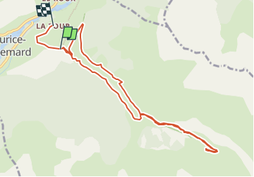
Ruta Senderismo de 10,5 km a descubrir en Provenza-Alpes-Costa Azul, Altos Alpes, Saint-Maurice-en-Valgodemard. Esta ruta ha sido propuesta por Bernard Rodriguez.
Descripción
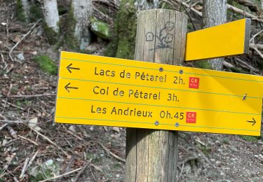
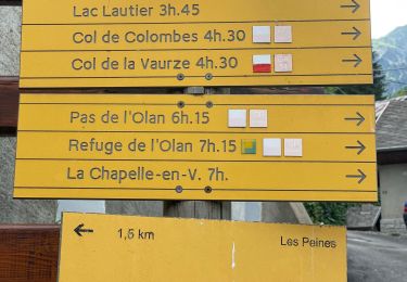
st maurice en valgodemar l'ubac départ traverser le Pont de la Scie et continuer à droite. Plus loin, laisser le GR à droite (retour) et poursuivre sur la piste qui s’élève progressivement à gauche. La suivre jusqu’aux Chalets de Prentiq. Traverser les ruines et dépasser la croix en bois.
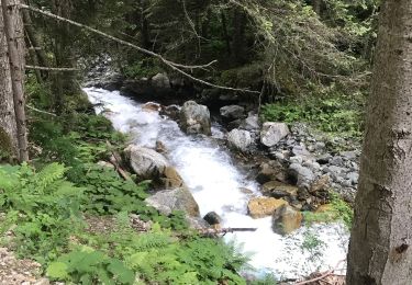
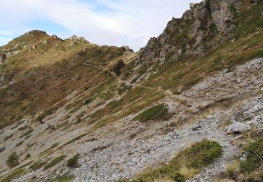
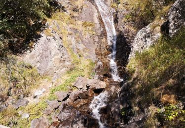
Plus loin, traverser la Draye de la Gorge puis dépasser les Sources des Doux. Poursuivre en pente plus douce jusqu’aux Prés du Sellar. Repérer la cabane homonyme un peu plus haut sur la droite. Traverser le lit du torrent (cairn) pour la rejoindre.
Redescendre par le même itinéraire jusqu’aux Chalets de Prentiq puis continuer sur le GR à gauche. Traverser le Torrent de Prentiq par une passerelle puis suivre le sentier longeant celui-ci dans la forêt.
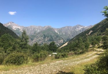
Enfin, retraverser le torrent par une autre passerelle en bois, retrouver la piste et rejoindre le parking de départ au Pont de la Scie.
Localización
Comentarios
Excursiones cerca
![Excursión Senderismo Villar-Loubière - Pic Turbat - Photo](https://media.geolcdn.com/t/375/260/d62b8d76-41e7-46f4-8b33-5d2b5ae47cbd.jpg&format=jpg&maxdim=2)
![Senderismo Senderismo](https://static1.geolcdn.com/sitytour/trail-icons/101.png)
Senderismo
![](/images/other/stat-length.png)
![](https://static1.geolcdn.com/siteimages/upload/files/16400158638029165_repeat_loop_refresh_sync_direction_icon.png)
![Excursión Senderismo Saint-Maurice-en-Valgodemard - Valgaudemar - l'Ubac Vallon de Prentiq - 14.9km 810m 5h15 - 2018 07 06 - public - Photo](https://media.geolcdn.com/t/375/260/ext.jpg?maxdim=2&url=https%3A%2F%2Fservices.sitytrail.com%2FGeolivesWS%2FDownloadMedia.ashx%3FTrailID%3D999693%26Media%3Dfix__20180706130523.jpg)
![Senderismo Senderismo](https://static1.geolcdn.com/sitytour/trail-icons/101.png)
Senderismo
![](/images/other/stat-length.png)
![](https://static1.geolcdn.com/siteimages/upload/files/16400158638029165_repeat_loop_refresh_sync_direction_icon.png)
![Excursión Senderismo Villar-Loubière - Petarel prentic - Photo](https://media.geolcdn.com/t/375/260/c252f157-a867-4376-a753-99f60e633638.jpg&format=jpg&maxdim=2)
![Senderismo Senderismo](https://static1.geolcdn.com/sitytour/trail-icons/101.png)
Senderismo
![](/images/other/stat-length.png)
![](https://static1.geolcdn.com/siteimages/upload/files/16400158638029165_repeat_loop_refresh_sync_direction_icon.png)
![Excursión Senderismo La Chapelle-en-Valgaudémar - Valgo2 - J2 : Col de Pétarel - Photo](https://media.geolcdn.com/t/375/260/a3d44dd2-2894-4e80-9c9f-921aabe27f1a.jpg&format=jpg&maxdim=2)
![Senderismo Senderismo](https://static1.geolcdn.com/sitytour/trail-icons/101.png)
Senderismo
![](/images/other/stat-length.png)
![](https://static1.geolcdn.com/siteimages/upload/files/16400158638029165_repeat_loop_refresh_sync_direction_icon.png)
![Excursión Senderismo Villar-Loubière - Col des clochettes - Photo](https://media.geolcdn.com/t/375/260/29cfc5ee-6d83-45be-b231-1befd2c5b10f.jpg&format=jpg&maxdim=2)
![Senderismo Senderismo](https://static1.geolcdn.com/sitytour/trail-icons/101.png)
Senderismo
![](/images/other/stat-length.png)
![](https://static1.geolcdn.com/siteimages/upload/files/16400158638029165_repeat_loop_refresh_sync_direction_icon.png)
![Excursión Senderismo Villar-Loubière - Valgo2 - J1 : Col des Clochettes - Photo](https://media.geolcdn.com/t/375/260/66a13825-0130-42f3-ad69-09aae21348f4.jpg&format=jpg&maxdim=2)
![Senderismo Senderismo](https://static1.geolcdn.com/sitytour/trail-icons/101.png)
Senderismo
![](/images/other/stat-length.png)
![](https://static1.geolcdn.com/siteimages/upload/files/16400158638029165_repeat_loop_refresh_sync_direction_icon.png)
![Excursión Senderismo Villar-Loubière - Cime de Turbat. - Photo](https://media.geolcdn.com/t/375/260/fd3d1c78-9f9e-44e7-943a-b9513249c00c.jpg&format=jpg&maxdim=2)
![Senderismo Senderismo](https://static1.geolcdn.com/sitytour/trail-icons/101.png)
Senderismo
![](/images/other/stat-length.png)
![](https://static1.geolcdn.com/siteimages/upload/files/16400158638029165_repeat_loop_refresh_sync_direction_icon.png)
![Excursión Senderismo Villar-Loubière - Refuge des souffles. - Photo](https://media.geolcdn.com/t/375/260/17d00521-8760-4402-86f9-28679cedc2bc.jpg&format=jpg&maxdim=2)
![Senderismo Senderismo](https://static1.geolcdn.com/sitytour/trail-icons/101.png)
Senderismo
![](/images/other/stat-length.png)
![](https://static1.geolcdn.com/siteimages/upload/files/16400158638029165_repeat_loop_refresh_sync_direction_icon.png)
![Senderismo Senderismo](https://static1.geolcdn.com/sitytour/trail-icons/101.png)
Senderismo
![](/images/other/stat-length.png)
![](https://static1.geolcdn.com/siteimages/upload/files/16400158638029165_repeat_loop_refresh_sync_direction_icon.png)