![](/images/other/stat-length.png)
![Excursión Senderismo Montmeyan - Quinson, Gorges basses du Verdon/chapelle Ste Maxime - Photo](https://media.geolcdn.com/t/1900/400/86e41310-a6a1-4450-8498-153a74c58f37.jpg&format=pjpeg&maxdim=2)
Quinson, Gorges basses du Verdon/chapelle Ste Maxime
PVERTICAL
Usuario
![Longitud](/images/other/stat-length.png)
![Altitud máxima](https://static1.geolcdn.com/siteimages/upload/files/1508320355ic_sort_altitude_max_24dp.png)
![Desnivel positivo](https://static1.geolcdn.com/siteimages/upload/files/1508320355ic_sort_den_pos_24dp.png)
![Km-Effort](/images/other/stat-length.png)
![Altitud mínima](https://static1.geolcdn.com/siteimages/upload/files/1508320355ic_sort_altitude_min_24dp.png)
![Desnivel negativo](https://static1.geolcdn.com/siteimages/upload/files/1508320355ic_sort_den_neg_24dp.png)
![Boucle](https://static1.geolcdn.com/siteimages/upload/files/16400158638029165_repeat_loop_refresh_sync_direction_icon.png)
![Senderismo](https://static1.geolcdn.com/sitytour/trail-icons/101.png)
2h41
Dificultad : Medio
![Escanee este código QR para abrir la excursión en la aplicación SityTrail](https://capi.geolives.com/qq0zvz2zws4bq2lad0pu/sitytour/trails/4105470/qr.png?size=200)
Aplicación GPS de excursión GRATIS
A propósito
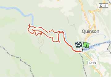
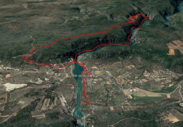
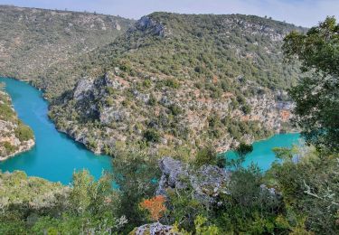
Ruta Senderismo de 9,6 km a descubrir en Provenza-Alpes-Costa Azul, Var, Montmeyan. Esta ruta ha sido propuesta por PVERTICAL.
Descripción
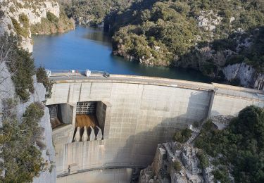
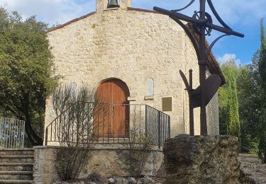
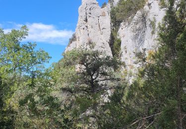
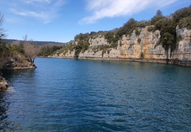
départ, places de stationnement payantes sauf accotements. belle randonnée assez ombragée, qui suit d'abord l'ancien canal du Verdon pour ensuite bifurquer en montant moyennement vers la chapelle Ste Maxime. Descente pour retrouver le canal et le point de départ. Possibilité de rester en crête au lieu de redescendre vers le sentier du canal mais cela rallonge.
Localización
Comentarios
Excursiones cerca
![Excursión Senderismo Quinson - basses-gorges-du-verdon-quinson - Photo](https://media.geolcdn.com/t/375/260/fd6a35eb-1609-4929-b5d2-8a81203636d1.jpg&format=jpg&maxdim=2)
![Senderismo Senderismo](https://static1.geolcdn.com/sitytour/trail-icons/101.png)
Senderismo
![](/images/other/stat-length.png)
![](https://static1.geolcdn.com/siteimages/upload/files/16400158638029165_repeat_loop_refresh_sync_direction_icon.png)
![Excursión Senderismo Montagnac-Montpezat - coteau Chiron - Photo](https://media.geolcdn.com/t/375/260/3e187ac9-75e1-43c3-8947-48bfa083c064.jpg&format=jpg&maxdim=2)
![Senderismo Senderismo](https://static1.geolcdn.com/sitytour/trail-icons/101.png)
Senderismo
![](/images/other/stat-length.png)
![](https://static1.geolcdn.com/siteimages/upload/files/16400158638029165_repeat_loop_refresh_sync_direction_icon.png)
![Excursión Senderismo Quinson - 2023-01-27 Quinson - Chemin de l'eau et retour rive droite - Photo](https://media.geolcdn.com/t/375/260/97297413-2275-4ba1-859c-43dda520a147.jpg&format=jpg&maxdim=2)
![Senderismo Senderismo](https://static1.geolcdn.com/sitytour/trail-icons/101.png)
Senderismo
![](/images/other/stat-length.png)
![](https://static1.geolcdn.com/siteimages/upload/files/16400158638029165_repeat_loop_refresh_sync_direction_icon.png)
![Excursión Senderismo Artignosc-sur-Verdon - 11-10-2022 Artignosc - Baudinard - Photo](https://media.geolcdn.com/t/375/260/6319543e-3c6d-4edb-87fc-022f3d7ccfd0.jpg&format=jpg&maxdim=2)
![Senderismo Senderismo](https://static1.geolcdn.com/sitytour/trail-icons/101.png)
Senderismo
![](/images/other/stat-length.png)
![](https://static1.geolcdn.com/siteimages/upload/files/16400158638029165_repeat_loop_refresh_sync_direction_icon.png)
![Excursión Senderismo Quinson - 02/10/2022 Quinson - Sentier de la préhistoire - Source de Poiraque - Photo](https://media.geolcdn.com/t/375/260/8826c718-a889-4bcd-aa44-238ee7e3a913.jpg&format=jpg&maxdim=2)
![Senderismo Senderismo](https://static1.geolcdn.com/sitytour/trail-icons/101.png)
Senderismo
![](/images/other/stat-length.png)
![](https://static1.geolcdn.com/siteimages/upload/files/16400158638029165_repeat_loop_refresh_sync_direction_icon.png)
![Excursión Senderismo Saint-Laurent-du-Verdon - 02-04-2022 Saint Laurent et son lac - Photo](https://media.geolcdn.com/t/375/260/c2cf26e1-67cf-4a0d-981e-e145b4285aa4.jpg&format=jpg&maxdim=2)
![Senderismo Senderismo](https://static1.geolcdn.com/sitytour/trail-icons/101.png)
Senderismo
![](/images/other/stat-length.png)
![](https://static1.geolcdn.com/siteimages/upload/files/16400158638029165_repeat_loop_refresh_sync_direction_icon.png)
![Excursión Senderismo Montmeyan - Verdon Sentier garde canal 05/03/2021 - Photo](https://media.geolcdn.com/t/375/260/ce25aa7b-f9a3-4891-9d04-b5ec9e3a380b.jpg&format=jpg&maxdim=2)
![Senderismo Senderismo](https://static1.geolcdn.com/sitytour/trail-icons/101.png)
Senderismo
![](/images/other/stat-length.png)
![](https://static1.geolcdn.com/siteimages/upload/files/16400158638029165_repeat_loop_refresh_sync_direction_icon.png)
![Excursión Senderismo Quinson - Chapelle Ste maxime, par les basses gorges du Verdon - Photo](https://media.geolcdn.com/t/375/260/ext.jpg?maxdim=2&url=https%3A%2F%2Fstatic1.geolcdn.com%2Fsiteimages%2Fupload%2Ffiles%2F1553511878bg_sport_marche.png)
![Senderismo Senderismo](https://static1.geolcdn.com/sitytour/trail-icons/101.png)
Senderismo
![](/images/other/stat-length.png)
![](https://static1.geolcdn.com/siteimages/upload/files/16400158638029165_repeat_loop_refresh_sync_direction_icon.png)
![Excursión Senderismo Quinson - Circuit Saint Maxime-basses gorges - Photo](https://media.geolcdn.com/t/375/260/ext.jpg?maxdim=2&url=https%3A%2F%2Fstatic1.geolcdn.com%2Fsiteimages%2Fupload%2Ffiles%2F1553511878bg_sport_marche.png)
![Senderismo Senderismo](https://static1.geolcdn.com/sitytour/trail-icons/101.png)
Senderismo
![](/images/other/stat-length.png)
![](https://static1.geolcdn.com/siteimages/upload/files/16400158638029165_repeat_loop_refresh_sync_direction_icon.png)