![](/images/other/stat-length.png)
![Excursión Senderismo Cleurie - Circuit Cleurie / ST Amé - le Fossard - Photo](https://media.geolcdn.com/t/1900/400/ext.pjpeg?maxdim=2&url=https%3A%2F%2Fmedia.geolcdn.com%2Ff%2F357e72c1-9c3e-42c8-b377-9a755632ac33.jpg)
Circuit Cleurie / ST Amé - le Fossard
Emmanuel Remy
Usuario
![Longitud](/images/other/stat-length.png)
Longitud
14,1 km
![Altitud máxima](https://static1.geolcdn.com/siteimages/upload/files/1508320355ic_sort_altitude_max_24dp.png)
Altitud máxima
796 m
![Desnivel positivo](https://static1.geolcdn.com/siteimages/upload/files/1508320355ic_sort_den_pos_24dp.png)
Desnivel positivo
332 m
![Km-Effort](/images/other/stat-length.png)
Km-Effort
18,5 km
![Altitud mínima](https://static1.geolcdn.com/siteimages/upload/files/1508320355ic_sort_altitude_min_24dp.png)
Altitud mínima
701 m
![Desnivel negativo](https://static1.geolcdn.com/siteimages/upload/files/1508320355ic_sort_den_neg_24dp.png)
Desnivel negativo
332 m
![Boucle](https://static1.geolcdn.com/siteimages/upload/files/16400158638029165_repeat_loop_refresh_sync_direction_icon.png)
Boucle
Sí
Fecha de creación :
2024-06-27 09:13:19.698
Última modificación :
2024-06-27 17:05:16.0
![Senderismo](https://static1.geolcdn.com/sitytour/trail-icons/101.png)
3h16
Dificultad : Fácil
![Escanee este código QR para abrir la excursión en la aplicación SityTrail](https://capi.geolives.com/qq0zvz2zws4bq2lad0pu/sitytour/trails/4104845/qr.png?size=200)
Aplicación GPS de excursión GRATIS
A propósito
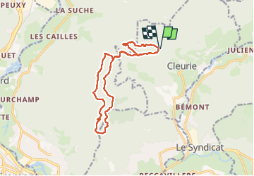
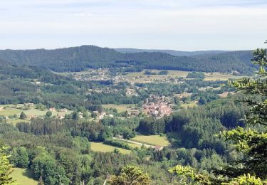
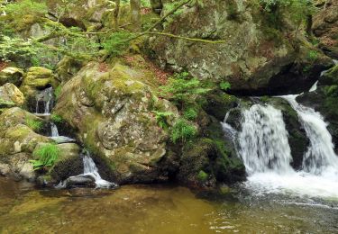
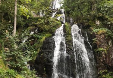
Ruta Senderismo de 14,1 km a descubrir en Gran Este, Vosgos, Cleurie. Esta ruta ha sido propuesta por Emmanuel Remy.
Descripción
Depuis Hêtre de la vierge
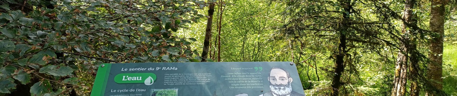
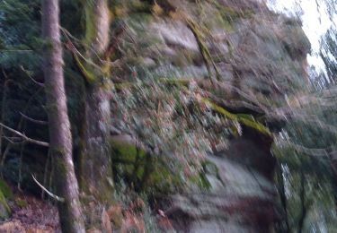
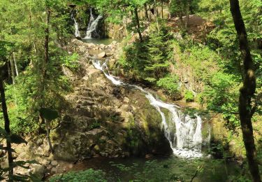
Localización
País:
France
Región :
Gran Este
Departamento/provincia :
Vosgos
Municipio :
Cleurie
Localidad:
Unknown
Salida:(Dec)
Salida:(UTM)
326043 ; 5325363 (32U) N.
Comentarios
Excursiones cerca
![Excursión Senderismo Éloyes - eloyes champ dolant - Photo](https://media.geolcdn.com/t/375/260/ext.jpg?maxdim=2&url=https%3A%2F%2Fmedia.geolcdn.com%2Ff%2F8221c7ad-810e-48e5-9b79-c276aa574b68.jpg)
![Senderismo Senderismo](https://static1.geolcdn.com/sitytour/trail-icons/101.png)
eloyes champ dolant
Senderismo
Medio
(2)
Éloyes,
Gran Este,
Vosgos,
France
![](/images/other/stat-length.png)
8,2 km | 12,4 km-effort
2h 26min
![](https://static1.geolcdn.com/siteimages/upload/files/16400158638029165_repeat_loop_refresh_sync_direction_icon.png)
Sí
![Excursión Senderismo Saint-Amé - carrière de Saint Amé - Photo](https://media.geolcdn.com/t/375/260/ext.jpg?maxdim=2&url=https%3A%2F%2Fservices.sitytrail.com%2FGeolivesWS%2FDownloadMedia.ashx%3FTrailID%3D430825%26Media%3D20150607155818.jpg)
![Senderismo Senderismo](https://static1.geolcdn.com/sitytour/trail-icons/101.png)
carrière de Saint Amé
Senderismo
Medio
(1)
Saint-Amé,
Gran Este,
Vosgos,
France
![](/images/other/stat-length.png)
8,6 km | 12,6 km-effort
2h 13min
![](https://static1.geolcdn.com/siteimages/upload/files/16400158638029165_repeat_loop_refresh_sync_direction_icon.png)
Sí
![Excursión Paseo ecuestre Le Tholy - 2022-06-03 Rando CVA Le Tholy Gerbamont - Photo](https://media.geolcdn.com/t/375/260/ext.jpg?maxdim=2&url=https%3A%2F%2Fmedia.geolcdn.com%2Ff%2F42a0cb90-f392-42d3-bd15-6748a5c05149.JPG)
![Paseo ecuestre Paseo ecuestre](https://static1.geolcdn.com/sitytour/trail-icons/301.png)
2022-06-03 Rando CVA Le Tholy Gerbamont
Paseo ecuestre
Muy difícil
Le Tholy,
Gran Este,
Vosgos,
France
![](/images/other/stat-length.png)
28 km | 41 km-effort
6h 25min
![](https://static1.geolcdn.com/siteimages/upload/files/16400158638029165_repeat_loop_refresh_sync_direction_icon.png)
No
![Excursión Paseo ecuestre Le Tholy - 2022-06-02 Rando CVA Le Tholy Tête des Cuveaux - Photo](https://media.geolcdn.com/t/375/260/ext.jpg?maxdim=2&url=https%3A%2F%2Fmedia.geolcdn.com%2Ff%2F655700ee-4545-4284-b9be-e2f2446a936f.jpg)
![Paseo ecuestre Paseo ecuestre](https://static1.geolcdn.com/sitytour/trail-icons/301.png)
2022-06-02 Rando CVA Le Tholy Tête des Cuveaux
Paseo ecuestre
Difícil
Le Tholy,
Gran Este,
Vosgos,
France
![](/images/other/stat-length.png)
28 km | 40 km-effort
5h 19min
![](https://static1.geolcdn.com/siteimages/upload/files/16400158638029165_repeat_loop_refresh_sync_direction_icon.png)
Sí
![Excursión Paseo ecuestre Le Tholy - 2022-06-01 Rando CVA Le Tholy Boucle Cascades du Tendon - Photo](https://media.geolcdn.com/t/375/260/ext.jpg?maxdim=2&url=https%3A%2F%2Fmedia.geolcdn.com%2Ff%2F98914552-e3a3-4585-82b4-ce3d7cbf4228.JPG)
![Paseo ecuestre Paseo ecuestre](https://static1.geolcdn.com/sitytour/trail-icons/301.png)
2022-06-01 Rando CVA Le Tholy Boucle Cascades du Tendon
Paseo ecuestre
Difícil
Le Tholy,
Gran Este,
Vosgos,
France
![](/images/other/stat-length.png)
24 km | 34 km-effort
5h 16min
![](https://static1.geolcdn.com/siteimages/upload/files/16400158638029165_repeat_loop_refresh_sync_direction_icon.png)
Sí
![Excursión Senderismo Remiremont - Remiremont (Girmont-Val-d'Ajol) 22 880m +729m - Photo](https://media.geolcdn.com/t/375/260/ext.jpg?maxdim=2&url=https%3A%2F%2Fstatic1.geolcdn.com%2Fsiteimages%2Fupload%2Ffiles%2F1553511878bg_sport_marche.png)
![Senderismo Senderismo](https://static1.geolcdn.com/sitytour/trail-icons/101.png)
Remiremont (Girmont-Val-d'Ajol) 22 880m +729m
Senderismo
Muy difícil
(1)
Remiremont,
Gran Este,
Vosgos,
France
![](/images/other/stat-length.png)
23 km | 33 km-effort
7h 24min
![](https://static1.geolcdn.com/siteimages/upload/files/16400158638029165_repeat_loop_refresh_sync_direction_icon.png)
Sí
![Excursión Senderismo Le Tholy - tendon - Photo](https://media.geolcdn.com/t/375/260/ext.jpg?maxdim=2&url=https%3A%2F%2Fstatic1.geolcdn.com%2Fsiteimages%2Fupload%2Ffiles%2F1553511878bg_sport_marche.png)
![Senderismo Senderismo](https://static1.geolcdn.com/sitytour/trail-icons/101.png)
![Excursión Senderismo Saint-Étienne-lès-Remiremont - rando chanoinesses 2024 - Photo](https://media.geolcdn.com/t/375/260/ext.jpg?maxdim=2&url=https%3A%2F%2Fmedia.geolcdn.com%2Ff%2F1f28ad57-0bac-42c5-a239-cee2db707493.jpg)
![Senderismo Senderismo](https://static1.geolcdn.com/sitytour/trail-icons/101.png)
rando chanoinesses 2024
Senderismo
Medio
Saint-Étienne-lès-Remiremont,
Gran Este,
Vosgos,
France
![](/images/other/stat-length.png)
12,5 km | 18 km-effort
2h 32min
![](https://static1.geolcdn.com/siteimages/upload/files/16400158638029165_repeat_loop_refresh_sync_direction_icon.png)
No
![Excursión Senderismo Saint-Étienne-lès-Remiremont - 20220324_projet_rando_ST-ETIENNE-LES-REMIREMONT_N_Sur_les_pas_de_St_Romary - Photo](https://media.geolcdn.com/t/375/260/ext.jpg?maxdim=2&url=https%3A%2F%2Fmedia.geolcdn.com%2Ff%2F264a1181-fa8b-4d31-b067-498da8b75069.jpg)
![Senderismo Senderismo](https://static1.geolcdn.com/sitytour/trail-icons/101.png)
20220324_projet_rando_ST-ETIENNE-LES-REMIREMONT_N_Sur_les_pas_de_St_Romary
Senderismo
Muy difícil
Saint-Étienne-lès-Remiremont,
Gran Este,
Vosgos,
France
![](/images/other/stat-length.png)
15,8 km | 25 km-effort
5h 36min
![](https://static1.geolcdn.com/siteimages/upload/files/16400158638029165_repeat_loop_refresh_sync_direction_icon.png)
Sí