![](/images/other/stat-length.png)
![Excursión Senderismo Rion-des-Landes - Prit (projet au bord du ruisseau) - Photo](https://media.geolcdn.com/t/1900/400/ext.pjpeg?maxdim=2&url=https%3A%2F%2Fstatic1.geolcdn.com%2Fsiteimages%2Fupload%2Ffiles%2F1553511878bg_sport_marche.png)
Prit (projet au bord du ruisseau)
les randonneurs rionnais
Pignada nous voilà
![Longitud](/images/other/stat-length.png)
Longitud
745 m
![Altitud máxima](https://static1.geolcdn.com/siteimages/upload/files/1508320355ic_sort_altitude_max_24dp.png)
Altitud máxima
80 m
![Desnivel positivo](https://static1.geolcdn.com/siteimages/upload/files/1508320355ic_sort_den_pos_24dp.png)
Desnivel positivo
8 m
![Km-Effort](/images/other/stat-length.png)
Km-Effort
835 m
![Altitud mínima](https://static1.geolcdn.com/siteimages/upload/files/1508320355ic_sort_altitude_min_24dp.png)
Altitud mínima
73 m
![Desnivel negativo](https://static1.geolcdn.com/siteimages/upload/files/1508320355ic_sort_den_neg_24dp.png)
Desnivel negativo
3 m
![Boucle](https://static1.geolcdn.com/siteimages/upload/files/16400158638029165_repeat_loop_refresh_sync_direction_icon.png)
Boucle
No
Fecha de creación :
2024-06-27 13:46:46.892
Última modificación :
2024-06-27 14:12:36.375
![Senderismo](https://static1.geolcdn.com/sitytour/trail-icons/101.png)
11m
Dificultad : Fácil
![Escanee este código QR para abrir la excursión en la aplicación SityTrail](https://capi.geolives.com/qq0zvz2zws4bq2lad0pu/sitytour/trails/4104503/qr.png?size=200)
Aplicación GPS de excursión GRATIS
A propósito
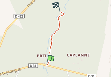
Ruta Senderismo de 745 m a descubrir en Nueva Aquitania, Landas, Rion-des-Landes. Esta ruta ha sido propuesta por les randonneurs rionnais.
Descripción
- trajet aller par parcelles 1 & 2
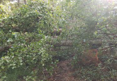
- retour hors parcelles Prit (chemin à nettoyer à la machine débrousailleuse et grand sécateur)
Localización
País:
France
Región :
Nueva Aquitania
Departamento/provincia :
Landas
Municipio :
Rion-des-Landes
Localidad:
Rion-des-Landes
Salida:(Dec)
Salida:(UTM)
668314 ; 4866722 (30T) N.
Comentarios
Excursiones cerca
![Excursión Senderismo Rion-des-Landes - retjons, prit, carreyre - 7 - Photo](https://media.geolcdn.com/t/375/260/ff91d5e6-2d63-47a1-ad7b-823d37ac495d.jpg&format=jpg&maxdim=2)
![Senderismo Senderismo](https://static1.geolcdn.com/sitytour/trail-icons/101.png)
retjons, prit, carreyre - 7
Senderismo
Medio
(1)
Rion-des-Landes,
Nueva Aquitania,
Landas,
France
![](/images/other/stat-length.png)
7 km | 7,9 km-effort
1h 47min
![](https://static1.geolcdn.com/siteimages/upload/files/16400158638029165_repeat_loop_refresh_sync_direction_icon.png)
Sí
![Excursión Senderismo Rion-des-Landes - Tuilerie, pouchon, pinache, loriou, mollenave - 7.2 - Photo](https://media.geolcdn.com/t/375/260/ext.jpg?maxdim=2&url=https%3A%2F%2Fstatic1.geolcdn.com%2Fsiteimages%2Fupload%2Ffiles%2F1553511878bg_sport_marche.png)
![Senderismo Senderismo](https://static1.geolcdn.com/sitytour/trail-icons/101.png)
Tuilerie, pouchon, pinache, loriou, mollenave - 7.2
Senderismo
Medio
(1)
Rion-des-Landes,
Nueva Aquitania,
Landas,
France
![](/images/other/stat-length.png)
7,2 km | 8 km-effort
1h 48min
![](https://static1.geolcdn.com/siteimages/upload/files/16400158638029165_repeat_loop_refresh_sync_direction_icon.png)
Sí
![Excursión Senderismo Rion-des-Landes - Maa Lessègues Miconine Bioy 7km - Photo](https://media.geolcdn.com/t/375/260/ext.jpg?maxdim=2&url=https%3A%2F%2Fstatic1.geolcdn.com%2Fsiteimages%2Fupload%2Ffiles%2F1553511878bg_sport_marche.png)
![Senderismo Senderismo](https://static1.geolcdn.com/sitytour/trail-icons/101.png)
Maa Lessègues Miconine Bioy 7km
Senderismo
Medio
(1)
Rion-des-Landes,
Nueva Aquitania,
Landas,
France
![](/images/other/stat-length.png)
7,3 km | 8,2 km-effort
1h 52min
![](https://static1.geolcdn.com/siteimages/upload/files/16400158638029165_repeat_loop_refresh_sync_direction_icon.png)
Sí
![Excursión Senderismo Beylongue - garricq, rive gauche jusqu'à passerelle poteaux, fontaine des sorcières, le buy, cosse -9.5 - Photo](https://media.geolcdn.com/t/375/260/ext.jpg?maxdim=2&url=https%3A%2F%2Fstatic1.geolcdn.com%2Fsiteimages%2Fupload%2Ffiles%2F1553511878bg_sport_marche.png)
![Senderismo Senderismo](https://static1.geolcdn.com/sitytour/trail-icons/101.png)
garricq, rive gauche jusqu'à passerelle poteaux, fontaine des sorcières, le b...
Senderismo
Medio
(1)
Beylongue,
Nueva Aquitania,
Landas,
France
![](/images/other/stat-length.png)
9,5 km | 11,2 km-effort
2h 33min
![](https://static1.geolcdn.com/siteimages/upload/files/16400158638029165_repeat_loop_refresh_sync_direction_icon.png)
Sí
![Excursión Senderismo Beylongue - garricq, rive gauche jusqu'à passerelle poteaux, fontaine des sorcières, le buy, cosse -9.6 - Photo](https://media.geolcdn.com/t/375/260/ext.jpg?maxdim=2&url=https%3A%2F%2Fstatic1.geolcdn.com%2Fsiteimages%2Fupload%2Ffiles%2F1553511878bg_sport_marche.png)
![Senderismo Senderismo](https://static1.geolcdn.com/sitytour/trail-icons/101.png)
garricq, rive gauche jusqu'à passerelle poteaux, fontaine des sorcières, le b...
Senderismo
Medio
(1)
Beylongue,
Nueva Aquitania,
Landas,
France
![](/images/other/stat-length.png)
9,6 km | 11,4 km-effort
2h 36min
![](https://static1.geolcdn.com/siteimages/upload/files/16400158638029165_repeat_loop_refresh_sync_direction_icon.png)
Sí
![Excursión Senderismo Beylongue - garricq, rive gauche jusqu'à passerelle poteaux, fontaine des sorcières, le buy, cosse - 9.1 - Photo](https://media.geolcdn.com/t/375/260/ext.jpg?maxdim=2&url=https%3A%2F%2Fstatic1.geolcdn.com%2Fsiteimages%2Fupload%2Ffiles%2F1553511878bg_sport_marche.png)
![Senderismo Senderismo](https://static1.geolcdn.com/sitytour/trail-icons/101.png)
garricq, rive gauche jusqu'à passerelle poteaux, fontaine des sorcières, le b...
Senderismo
Medio
(1)
Beylongue,
Nueva Aquitania,
Landas,
France
![](/images/other/stat-length.png)
9,1 km | 10,7 km-effort
2h 25min
![](https://static1.geolcdn.com/siteimages/upload/files/16400158638029165_repeat_loop_refresh_sync_direction_icon.png)
Sí
![Excursión Senderismo Beylongue - garricq, rive gauche jusqu'à passerelle poteaux, fontaine des sorcières - 7 - Photo](https://media.geolcdn.com/t/375/260/ext.jpg?maxdim=2&url=https%3A%2F%2Fstatic1.geolcdn.com%2Fsiteimages%2Fupload%2Ffiles%2F1553511878bg_sport_marche.png)
![Senderismo Senderismo](https://static1.geolcdn.com/sitytour/trail-icons/101.png)
garricq, rive gauche jusqu'à passerelle poteaux, fontaine des sorcières - 7
Senderismo
Fácil
(1)
Beylongue,
Nueva Aquitania,
Landas,
France
![](/images/other/stat-length.png)
7 km | 8,1 km-effort
1h 30min
![](https://static1.geolcdn.com/siteimages/upload/files/16400158638029165_repeat_loop_refresh_sync_direction_icon.png)
Sí
![Excursión Senderismo Beylongue - garricq, rive gauche jusqu'à passerelle poteaux, fontaine des sorcières - 7,3 - Photo](https://media.geolcdn.com/t/375/260/ext.jpg?maxdim=2&url=https%3A%2F%2Fstatic1.geolcdn.com%2Fsiteimages%2Fupload%2Ffiles%2F1553511878bg_sport_marche.png)
![Senderismo Senderismo](https://static1.geolcdn.com/sitytour/trail-icons/101.png)
garricq, rive gauche jusqu'à passerelle poteaux, fontaine des sorcières - 7,3
Senderismo
Medio
(1)
Beylongue,
Nueva Aquitania,
Landas,
France
![](/images/other/stat-length.png)
7,3 km | 8,5 km-effort
1h 55min
![](https://static1.geolcdn.com/siteimages/upload/files/16400158638029165_repeat_loop_refresh_sync_direction_icon.png)
Sí