![](/images/other/stat-length.png)
![Excursión Senderismo Schalkenmehren - 30 juin Boucle Wein Felder Maar - Photo](https://media.geolcdn.com/t/1900/400/ext.pjpeg?maxdim=2&url=https%3A%2F%2Fstatic1.geolcdn.com%2Fsiteimages%2Fupload%2Ffiles%2F1553511878bg_sport_marche.png)
30 juin Boucle Wein Felder Maar
Z14
Usuario
![Longitud](/images/other/stat-length.png)
![Altitud máxima](https://static1.geolcdn.com/siteimages/upload/files/1508320355ic_sort_altitude_max_24dp.png)
![Desnivel positivo](https://static1.geolcdn.com/siteimages/upload/files/1508320355ic_sort_den_pos_24dp.png)
![Km-Effort](/images/other/stat-length.png)
![Altitud mínima](https://static1.geolcdn.com/siteimages/upload/files/1508320355ic_sort_altitude_min_24dp.png)
![Desnivel negativo](https://static1.geolcdn.com/siteimages/upload/files/1508320355ic_sort_den_neg_24dp.png)
![Boucle](https://static1.geolcdn.com/siteimages/upload/files/16400158638029165_repeat_loop_refresh_sync_direction_icon.png)
![Senderismo](https://static1.geolcdn.com/sitytour/trail-icons/101.png)
4h54
Dificultad : Muy difícil
![Escanee este código QR para abrir la excursión en la aplicación SityTrail](https://capi.geolives.com/qq0zvz2zws4bq2lad0pu/sitytour/trails/4101909/qr.png?size=200)
Aplicación GPS de excursión GRATIS
A propósito
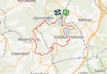
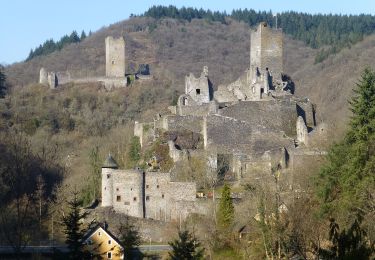
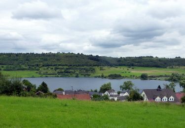
Ruta Senderismo de 16 km a descubrir en Renania-Palatinado, Landkreis Vulkaneifel, Schalkenmehren. Esta ruta ha sido propuesta por Z14.
Descripción
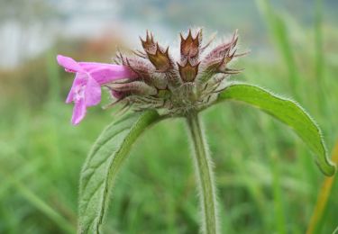
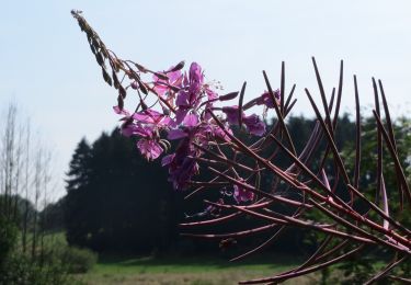
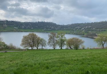
Cette balade à travers forêts et prés mène à la découverte de trois petits lacs qui comblent le fond d'anciens cratères, les "Maar".
Chapelle et petit cimetière (Weinfeld) en début de parcours.
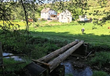
Pas de difficulté particulière.
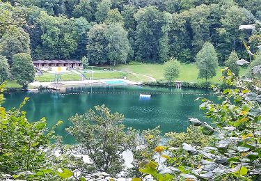
Abri et bancs pour un pique-nique à mi-chemin, auprès d'un étang.
Restauration possible à Schalkenmehren, au douzième kilomètre.
Localización
Comentarios
Excursiones cerca
![Excursión A pie Daun - HeimatSpur Großer Dauner - Photo](https://media.geolcdn.com/t/375/260/c7f2fcb7-dac5-4db8-bc46-541d9f834168.jpeg&format=jpg&maxdim=2)
![A pie A pie](https://static1.geolcdn.com/sitytour/trail-icons/100.png)
A pie
![](/images/other/stat-length.png)
![](https://static1.geolcdn.com/siteimages/upload/files/16400158638029165_repeat_loop_refresh_sync_direction_icon.png)
![Excursión A pie Üdersdorf - HeimatSpur Wasser- und Felsenweg - Photo](https://media.geolcdn.com/t/375/260/2a06d58d-a40a-4c3b-9920-9399a98721d8.jpeg&format=jpg&maxdim=2)
![A pie A pie](https://static1.geolcdn.com/sitytour/trail-icons/100.png)
A pie
![](/images/other/stat-length.png)
![](https://static1.geolcdn.com/siteimages/upload/files/16400158638029165_repeat_loop_refresh_sync_direction_icon.png)
![Excursión A pie Steineberg - HeimatSpur Keltenrundweg - Photo](https://media.geolcdn.com/t/375/260/4b1692aa-f11b-4d67-8202-607607da5a44.jpeg&format=jpg&maxdim=2)
![A pie A pie](https://static1.geolcdn.com/sitytour/trail-icons/100.png)
A pie
![](/images/other/stat-length.png)
![](https://static1.geolcdn.com/siteimages/upload/files/16400158638029165_repeat_loop_refresh_sync_direction_icon.png)
![Excursión A pie Schalkenmehren - HeimatSpur Maareglück - Photo](https://media.geolcdn.com/t/375/260/cbd6f176-1f85-46b9-810b-a27d08e42f51.jpeg&format=jpg&maxdim=2)
![A pie A pie](https://static1.geolcdn.com/sitytour/trail-icons/100.png)
A pie
![](/images/other/stat-length.png)
![](https://static1.geolcdn.com/siteimages/upload/files/16400158638029165_repeat_loop_refresh_sync_direction_icon.png)
![Excursión A pie Ellscheid - HeimatSpur Antoniusweg - Photo](https://media.geolcdn.com/t/375/260/e2ac7d32-3d28-4bd5-b014-b033b8555420.jpeg&format=jpg&maxdim=2)
![A pie A pie](https://static1.geolcdn.com/sitytour/trail-icons/100.png)
A pie
![](/images/other/stat-length.png)
![](https://static1.geolcdn.com/siteimages/upload/files/16400158638029165_repeat_loop_refresh_sync_direction_icon.png)
![Excursión A pie Schalkenmehren - Lieserpfad - Photo](https://media.geolcdn.com/t/375/260/53574610-aaca-459d-b253-05eac0ad6a61.jpeg&format=jpg&maxdim=2)
![A pie A pie](https://static1.geolcdn.com/sitytour/trail-icons/100.png)
A pie
![](/images/other/stat-length.png)
![](https://static1.geolcdn.com/siteimages/upload/files/16400158638029165_repeat_loop_refresh_sync_direction_icon.png)
![Excursión Senderismo Daun - Les 3 Maars de Daun (Eifel) - Photo](https://media.geolcdn.com/t/375/260/61bd873f-19aa-487d-992d-48eb1acfb1df.jpeg&format=jpg&maxdim=2)
![Senderismo Senderismo](https://static1.geolcdn.com/sitytour/trail-icons/101.png)
Senderismo
![](/images/other/stat-length.png)
![](https://static1.geolcdn.com/siteimages/upload/files/16400158638029165_repeat_loop_refresh_sync_direction_icon.png)
![Excursión A pie Darscheid - HeimatSpur Pfad der Artenvielfalt - Photo](https://media.geolcdn.com/t/375/260/46945c2e-932f-4377-b136-a41388844541.jpeg&format=jpg&maxdim=2)
![A pie A pie](https://static1.geolcdn.com/sitytour/trail-icons/100.png)
A pie
![](/images/other/stat-length.png)
![](https://static1.geolcdn.com/siteimages/upload/files/16400158638029165_repeat_loop_refresh_sync_direction_icon.png)
![Excursión A pie Schalkenmehren - Rundweg 3 - Photo](https://media.geolcdn.com/t/375/260/87838d5b-9384-42ea-b6c5-fa4eff6f87f1.jpeg&format=jpg&maxdim=2)
![A pie A pie](https://static1.geolcdn.com/sitytour/trail-icons/100.png)
A pie
![](/images/other/stat-length.png)
![](https://static1.geolcdn.com/siteimages/upload/files/16400158638029165_repeat_loop_refresh_sync_direction_icon.png)