![](/images/other/stat-length.png)
![Excursión Senderismo Auriol - Les Encanaux, Auriol-05-06-24 - Photo](https://media.geolcdn.com/t/1900/400/4f585078-9323-4b69-b9ad-98d39eead66e.jpg&format=pjpeg&maxdim=2)
Les Encanaux, Auriol-05-06-24
Christiancordin
Usuario
![Longitud](/images/other/stat-length.png)
Longitud
15,4 km
![Altitud máxima](https://static1.geolcdn.com/siteimages/upload/files/1508320355ic_sort_altitude_max_24dp.png)
Altitud máxima
795 m
![Desnivel positivo](https://static1.geolcdn.com/siteimages/upload/files/1508320355ic_sort_den_pos_24dp.png)
Desnivel positivo
619 m
![Km-Effort](/images/other/stat-length.png)
Km-Effort
24 km
![Altitud mínima](https://static1.geolcdn.com/siteimages/upload/files/1508320355ic_sort_altitude_min_24dp.png)
Altitud mínima
244 m
![Desnivel negativo](https://static1.geolcdn.com/siteimages/upload/files/1508320355ic_sort_den_neg_24dp.png)
Desnivel negativo
618 m
![Boucle](https://static1.geolcdn.com/siteimages/upload/files/16400158638029165_repeat_loop_refresh_sync_direction_icon.png)
Boucle
Sí
Fecha de creación :
2024-06-05 07:10:31.566
Última modificación :
2024-06-19 16:25:22.787
![Senderismo](https://static1.geolcdn.com/sitytour/trail-icons/101.png)
4h09
Dificultad : Medio
![Escanee este código QR para abrir la excursión en la aplicación SityTrail](https://capi.geolives.com/qq0zvz2zws4bq2lad0pu/sitytour/trails/4080572/qr.png?size=200)
Aplicación GPS de excursión GRATIS
A propósito
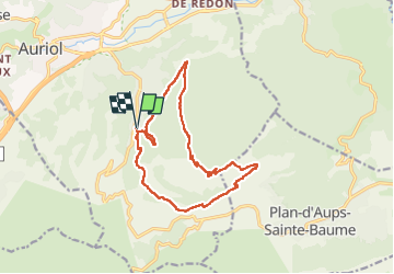
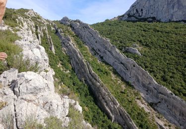
Ruta Senderismo de 15,4 km a descubrir en Provenza-Alpes-Costa Azul, Bocas del Ródano, Auriol. Esta ruta ha sido propuesta por Christiancordin.
Descripción
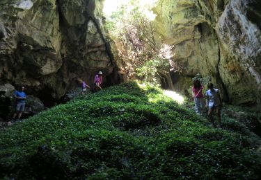
PK, pont des Encanaux, les Hélianthes, GR de pays Marseille Provence métropole, ravin de la Coutronne- grottes des morts et des Infernets, abri du figuier, glacière des Encanaux.
Localización
País:
France
Región :
Provenza-Alpes-Costa Azul
Departamento/provincia :
Bocas del Ródano
Municipio :
Auriol
Localidad:
Unknown
Salida:(Dec)
Salida:(UTM)
715599 ; 4803178 (31T) N.
Comentarios
Excursiones cerca
![Excursión Senderismo Gémenos - dent de roque forcade. cauvin.bertagne. 2 avril 2018 - Photo](https://media.geolcdn.com/t/375/260/ext.jpg?maxdim=2&url=https%3A%2F%2Fservices.sitytrail.com%2FGeolivesWS%2FDownloadMedia.ashx%3FTrailID%3D935467%26Media%3Dfix__20180402124207.jpg)
![Senderismo Senderismo](https://static1.geolcdn.com/sitytour/trail-icons/101.png)
dent de roque forcade. cauvin.bertagne. 2 avril 2018
Senderismo
Medio
(1)
Gémenos,
Provenza-Alpes-Costa Azul,
Bocas del Ródano,
France
![](/images/other/stat-length.png)
12,7 km | 20 km-effort
4h 31min
![](https://static1.geolcdn.com/siteimages/upload/files/16400158638029165_repeat_loop_refresh_sync_direction_icon.png)
Sí
![Excursión Senderismo Auriol - la crete des infernets - Photo](https://media.geolcdn.com/t/375/260/ext.jpg?maxdim=2&url=https%3A%2F%2Fservices.sitytrail.com%2FGeolivesWS%2FDownloadMedia.ashx%3FTrailID%3D867921%26Media%3Dfix__20171126111949.jpg)
![Senderismo Senderismo](https://static1.geolcdn.com/sitytour/trail-icons/101.png)
la crete des infernets
Senderismo
Difícil
(1)
Auriol,
Provenza-Alpes-Costa Azul,
Bocas del Ródano,
France
![](/images/other/stat-length.png)
8,6 km | 14 km-effort
3h 22min
![](https://static1.geolcdn.com/siteimages/upload/files/16400158638029165_repeat_loop_refresh_sync_direction_icon.png)
Sí
![Excursión Senderismo Gémenos - Autour des Dents de Roque Forcade, Tour de Cauvin - Photo](https://media.geolcdn.com/t/375/260/ext.jpg?maxdim=2&url=https%3A%2F%2Fservices.sitytrail.com%2FGeolivesWS%2FDownloadMedia.ashx%3FTrailID%3D107626%26Media%3D12610_1.jpg)
![Senderismo Senderismo](https://static1.geolcdn.com/sitytour/trail-icons/101.png)
Autour des Dents de Roque Forcade, Tour de Cauvin
Senderismo
Difícil
(1)
Gémenos,
Provenza-Alpes-Costa Azul,
Bocas del Ródano,
France
![](/images/other/stat-length.png)
7,6 km | 11,7 km-effort
3h 15min
![](https://static1.geolcdn.com/siteimages/upload/files/16400158638029165_repeat_loop_refresh_sync_direction_icon.png)
Sí
![Excursión Senderismo Plan-d'Aups-Sainte-Baume - La Grotte aux oiseaux - Plan d'Aups - Photo](https://media.geolcdn.com/t/375/260/ext.jpg?maxdim=2&url=https%3A%2F%2Fservices.sitytrail.com%2FGeolivesWS%2FDownloadMedia.ashx%3FTrailID%3D103826%26Media%3D6600_1.jpg)
![Senderismo Senderismo](https://static1.geolcdn.com/sitytour/trail-icons/101.png)
La Grotte aux oiseaux - Plan d'Aups
Senderismo
Medio
(1)
Plan-d'Aups-Sainte-Baume,
Provenza-Alpes-Costa Azul,
Var,
France
![](/images/other/stat-length.png)
8,8 km | 12,5 km-effort
2h 30min
![](https://static1.geolcdn.com/siteimages/upload/files/16400158638029165_repeat_loop_refresh_sync_direction_icon.png)
Sí
![Excursión A pie Auriol - Les moulins - Photo](https://media.geolcdn.com/t/375/260/401f3ad9-0fae-41b8-b152-a635d6eb468f.jpeg&format=jpg&maxdim=2)
![A pie A pie](https://static1.geolcdn.com/sitytour/trail-icons/100.png)
Les moulins
A pie
Fácil
Auriol,
Provenza-Alpes-Costa Azul,
Bocas del Ródano,
France
![](/images/other/stat-length.png)
3,7 km | 4,2 km-effort
57min
![](https://static1.geolcdn.com/siteimages/upload/files/16400158638029165_repeat_loop_refresh_sync_direction_icon.png)
Sí
![Excursión Senderismo Auriol - le ravin des Encanaux - Photo](https://media.geolcdn.com/t/375/260/0d6477e8-e2d8-4d99-b893-ff8f37b49a9c.jpg&format=jpg&maxdim=2)
![Senderismo Senderismo](https://static1.geolcdn.com/sitytour/trail-icons/101.png)
le ravin des Encanaux
Senderismo
Difícil
Auriol,
Provenza-Alpes-Costa Azul,
Bocas del Ródano,
France
![](/images/other/stat-length.png)
7,3 km | 12,2 km-effort
3h 10min
![](https://static1.geolcdn.com/siteimages/upload/files/16400158638029165_repeat_loop_refresh_sync_direction_icon.png)
Sí
![Excursión Senderismo Plan-d'Aups-Sainte-Baume - Pic de Bertagne - Grotte Betton - Le plan d'aups - Photo](https://media.geolcdn.com/t/375/260/ad49718c-76f4-4694-8c1c-399f42429ef6.jpg&format=jpg&maxdim=2)
![Senderismo Senderismo](https://static1.geolcdn.com/sitytour/trail-icons/101.png)
Pic de Bertagne - Grotte Betton - Le plan d'aups
Senderismo
Medio
Plan-d'Aups-Sainte-Baume,
Provenza-Alpes-Costa Azul,
Var,
France
![](/images/other/stat-length.png)
9,9 km | 15,7 km-effort
3h 30min
![](https://static1.geolcdn.com/siteimages/upload/files/16400158638029165_repeat_loop_refresh_sync_direction_icon.png)
Sí
![Excursión Senderismo Gémenos - de l'Espigoulier à Bertagne par les dents de roque forcade - Photo](https://media.geolcdn.com/t/375/260/ext.jpg?maxdim=2&url=https%3A%2F%2Fservices.sitytrail.com%2FGeolivesWS%2FDownloadMedia.ashx%3FTrailID%3D436505%26Media%3Df2069f22-7489-4adc-b49e-c5e55e3ea2a2.JPG)
![Senderismo Senderismo](https://static1.geolcdn.com/sitytour/trail-icons/101.png)
de l'Espigoulier à Bertagne par les dents de roque forcade
Senderismo
Medio
Gémenos,
Provenza-Alpes-Costa Azul,
Bocas del Ródano,
France
![](/images/other/stat-length.png)
6,9 km | 11,7 km-effort
6h 40min
![](https://static1.geolcdn.com/siteimages/upload/files/16400158638029165_repeat_loop_refresh_sync_direction_icon.png)
Sí
![Excursión Senderismo Plan-d'Aups-Sainte-Baume - Tour Cauvin, Dent de Roque Forcade, grotte de la Grande Baume - Photo](https://media.geolcdn.com/t/375/260/bc01032a-b83b-4472-9a16-75fe460f864f.jpg&format=jpg&maxdim=2)
![Senderismo Senderismo](https://static1.geolcdn.com/sitytour/trail-icons/101.png)
Tour Cauvin, Dent de Roque Forcade, grotte de la Grande Baume
Senderismo
Muy difícil
Plan-d'Aups-Sainte-Baume,
Provenza-Alpes-Costa Azul,
Var,
France
![](/images/other/stat-length.png)
13 km | 20 km-effort
4h 35min
![](https://static1.geolcdn.com/siteimages/upload/files/16400158638029165_repeat_loop_refresh_sync_direction_icon.png)
Sí