![](/images/other/stat-length.png)
![Excursión Senderismo Mayres-Savel - Passerelles himalayennes du Monteynard - Photo](https://media.geolcdn.com/t/1900/400/ext.pjpeg?maxdim=2&url=https%3A%2F%2Fstatic1.geolcdn.com%2Fsiteimages%2Fupload%2Ffiles%2F1553511878bg_sport_marche.png)
Passerelles himalayennes du Monteynard
Maryma
Usuario
![Longitud](/images/other/stat-length.png)
![Altitud máxima](https://static1.geolcdn.com/siteimages/upload/files/1508320355ic_sort_altitude_max_24dp.png)
![Desnivel positivo](https://static1.geolcdn.com/siteimages/upload/files/1508320355ic_sort_den_pos_24dp.png)
![Km-Effort](/images/other/stat-length.png)
![Altitud mínima](https://static1.geolcdn.com/siteimages/upload/files/1508320355ic_sort_altitude_min_24dp.png)
![Desnivel negativo](https://static1.geolcdn.com/siteimages/upload/files/1508320355ic_sort_den_neg_24dp.png)
![Boucle](https://static1.geolcdn.com/siteimages/upload/files/16400158638029165_repeat_loop_refresh_sync_direction_icon.png)
![Senderismo](https://static1.geolcdn.com/sitytour/trail-icons/101.png)
4h08
Dificultad : Medio
![Escanee este código QR para abrir la excursión en la aplicación SityTrail](https://capi.geolives.com/qq0zvz2zws4bq2lad0pu/sitytour/trails/4076497/qr.png?size=200)
Aplicación GPS de excursión GRATIS
A propósito
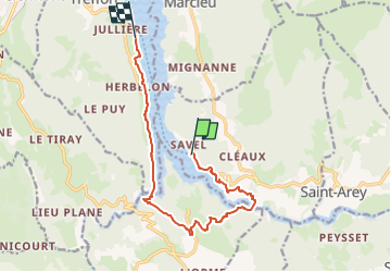
Ruta Senderismo de 11,9 km a descubrir en Auvergne-Rhône-Alpes, Isère, Mayres-Savel. Esta ruta ha sido propuesta por Maryma.
Descripción
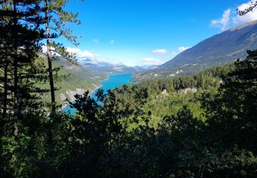
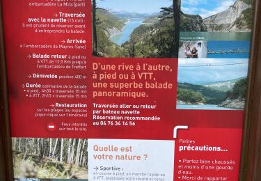
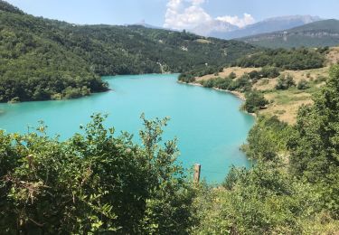
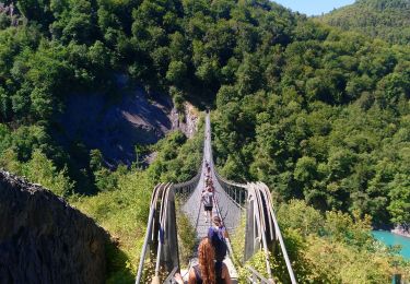
Départ depuis Treffort ou depuis Mayres-Savel.
Commencez par une traversée commentée de 30 minutes en bateau afin de rejoindre l'autre rive. Puis débutez la randonnée pour revenir au point de départ en empruntant les deux passerelles. Celle du Drac mesure 220 mètres de long, et celle de l'Ebron mesure 180 mètres. Expérience surprenante à 80 mètres au dessus du lac!
Localización
Comentarios
Excursiones cerca
![Excursión Senderismo Mayres-Savel - Passerelles Du Drac Et de L'Ebron - Photo](https://media.geolcdn.com/t/375/260/f4846bf3-414e-4c51-a6cb-c2da9b823649.jpg&format=jpg&maxdim=2)
![Senderismo Senderismo](https://static1.geolcdn.com/sitytour/trail-icons/101.png)
Senderismo
![](/images/other/stat-length.png)
![](https://static1.geolcdn.com/siteimages/upload/files/16400158638029165_repeat_loop_refresh_sync_direction_icon.png)
![Excursión Caballo Roissard - Trieves - Devoluy - Photo](https://media.geolcdn.com/t/375/260/532091fd-ff63-40b6-9790-4b260fef3e51.jpg&format=jpg&maxdim=2)
![Caballo Caballo](https://static1.geolcdn.com/sitytour/trail-icons/300.png)
Caballo
![](/images/other/stat-length.png)
![](https://static1.geolcdn.com/siteimages/upload/files/16400158638029165_repeat_loop_refresh_sync_direction_icon.png)
![Excursión Senderismo Mayres-Savel - Passerelles Hymalayene Mayres + 250 - Photo](https://media.geolcdn.com/t/375/260/e79ec6b2-c62a-43e0-95ca-91baa034bf5d.jpg&format=jpg&maxdim=2)
![Senderismo Senderismo](https://static1.geolcdn.com/sitytour/trail-icons/101.png)
Senderismo
![](/images/other/stat-length.png)
![](https://static1.geolcdn.com/siteimages/upload/files/16400158638029165_repeat_loop_refresh_sync_direction_icon.png)
![Excursión Senderismo Treffort - ISERE: MONTEYNARD PASSERELLES HIMALAYENNES - Photo](https://media.geolcdn.com/t/375/260/76721c9b-6b33-4db9-86bf-ba7e9a8d140f.jpg&format=jpg&maxdim=2)
![Senderismo Senderismo](https://static1.geolcdn.com/sitytour/trail-icons/101.png)
Senderismo
![](/images/other/stat-length.png)
![](https://static1.geolcdn.com/siteimages/upload/files/16400158638029165_repeat_loop_refresh_sync_direction_icon.png)
![Excursión Senderismo Mayres-Savel - Randonnée des passerelles - Photo](https://media.geolcdn.com/t/375/260/f81885ad-9d99-466e-990d-175fbd3a925e.jpg&format=jpg&maxdim=2)
![Senderismo Senderismo](https://static1.geolcdn.com/sitytour/trail-icons/101.png)
Senderismo
![](/images/other/stat-length.png)
![](https://static1.geolcdn.com/siteimages/upload/files/16400158638029165_repeat_loop_refresh_sync_direction_icon.png)
![Excursión Senderismo Treffort - Valgo2 - J3. : les passerelles de Monteynard - Photo](https://media.geolcdn.com/t/375/260/80ded9ce-faa3-4fe9-b5ad-3607bd08278e.jpg&format=jpg&maxdim=2)
![Senderismo Senderismo](https://static1.geolcdn.com/sitytour/trail-icons/101.png)
Senderismo
![](/images/other/stat-length.png)
![](https://static1.geolcdn.com/siteimages/upload/files/16400158638029165_repeat_loop_refresh_sync_direction_icon.png)
![Excursión Senderismo Treffort - Passerelle Drac - Photo](https://media.geolcdn.com/t/375/260/feb433be-0155-46e7-819a-3b1bb0447bc5.jpg&format=jpg&maxdim=2)
![Senderismo Senderismo](https://static1.geolcdn.com/sitytour/trail-icons/101.png)
Senderismo
![](/images/other/stat-length.png)
![](https://static1.geolcdn.com/siteimages/upload/files/16400158638029165_repeat_loop_refresh_sync_direction_icon.png)
![Excursión Senderismo Treffort - Les deux passerelles Drac et Ebron - Photo](https://media.geolcdn.com/t/375/260/3778f66d-36c2-41c5-9e06-64b09fbd2374.jpg&format=jpg&maxdim=2)
![Senderismo Senderismo](https://static1.geolcdn.com/sitytour/trail-icons/101.png)
Senderismo
![](/images/other/stat-length.png)
![](https://static1.geolcdn.com/siteimages/upload/files/16400158638029165_repeat_loop_refresh_sync_direction_icon.png)
![Excursión Senderismo Lavars - Serre de la Fayolle - Photo](https://media.geolcdn.com/t/375/260/95bdaed1-9210-48db-8488-a02aafbf5b89.jpg&format=jpg&maxdim=2)
![Senderismo Senderismo](https://static1.geolcdn.com/sitytour/trail-icons/101.png)
Senderismo
![](/images/other/stat-length.png)
![](https://static1.geolcdn.com/siteimages/upload/files/16400158638029165_repeat_loop_refresh_sync_direction_icon.png)