![](/images/other/stat-length.png)
![Excursión Senderismo Devesset - lac de Devesset Tour J3 HL - Photo](https://media.geolcdn.com/t/1900/400/ext.pjpeg?maxdim=2&url=https%3A%2F%2Fstatic1.geolcdn.com%2Fsiteimages%2Fupload%2Ffiles%2F1553511878bg_sport_marche.png)
lac de Devesset Tour J3 HL
pascalmilpas
Usuario
![Longitud](/images/other/stat-length.png)
Longitud
10,4 km
![Altitud máxima](https://static1.geolcdn.com/siteimages/upload/files/1508320355ic_sort_altitude_max_24dp.png)
Altitud máxima
1174 m
![Desnivel positivo](https://static1.geolcdn.com/siteimages/upload/files/1508320355ic_sort_den_pos_24dp.png)
Desnivel positivo
209 m
![Km-Effort](/images/other/stat-length.png)
Km-Effort
13,2 km
![Altitud mínima](https://static1.geolcdn.com/siteimages/upload/files/1508320355ic_sort_altitude_min_24dp.png)
Altitud mínima
1044 m
![Desnivel negativo](https://static1.geolcdn.com/siteimages/upload/files/1508320355ic_sort_den_neg_24dp.png)
Desnivel negativo
211 m
![Boucle](https://static1.geolcdn.com/siteimages/upload/files/16400158638029165_repeat_loop_refresh_sync_direction_icon.png)
Boucle
Sí
Fecha de creación :
2024-05-30 07:33:06.603
Última modificación :
2024-05-30 10:47:30.579
![Senderismo](https://static1.geolcdn.com/sitytour/trail-icons/101.png)
3h10
Dificultad : Difícil
![Escanee este código QR para abrir la excursión en la aplicación SityTrail](https://capi.geolives.com/qq0zvz2zws4bq2lad0pu/sitytour/trails/4073413/qr.png?size=200)
Aplicación GPS de excursión GRATIS
A propósito
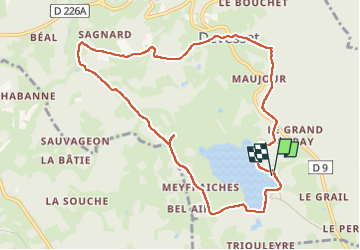
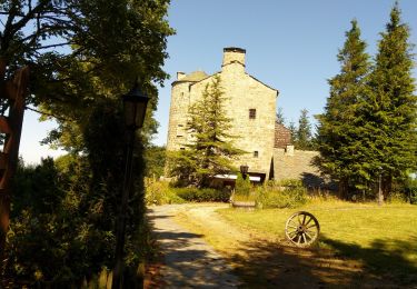
Ruta Senderismo de 10,4 km a descubrir en Auvergne-Rhône-Alpes, Ardecha, Devesset. Esta ruta ha sido propuesta por pascalmilpas.
Descripción
Boucle au départ de la Base Loisirs
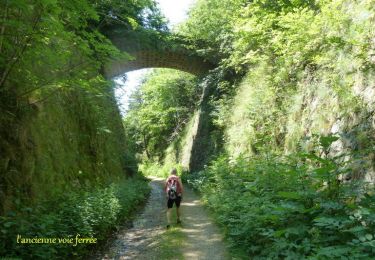
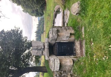
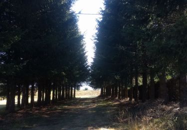
10 kms très faciles et larges chemins arborés avec de magnifiques ruisseaux et des arbres remarquables
Localización
País:
France
Región :
Auvergne-Rhône-Alpes
Departamento/provincia :
Ardecha
Municipio :
Devesset
Localidad:
Unknown
Salida:(Dec)
Salida:(UTM)
609898 ; 4989651 (31T) N.
Comentarios
Excursiones cerca
![Excursión Senderismo Saint-Jeure-d'Andaure - En pays d'Andaure - Photo](https://media.geolcdn.com/t/375/260/ext.jpg?maxdim=2&url=https%3A%2F%2Fservices.sitytrail.com%2FGeolivesWS%2FDownloadMedia.ashx%3FTrailID%3D129815%26Media%3D13364_6.jpg)
![Senderismo Senderismo](https://static1.geolcdn.com/sitytour/trail-icons/101.png)
En pays d'Andaure
Senderismo
Medio
(1)
Saint-Jeure-d'Andaure,
Auvergne-Rhône-Alpes,
Ardecha,
France
![](/images/other/stat-length.png)
6,8 km | 10,1 km-effort
2h 30min
![](https://static1.geolcdn.com/siteimages/upload/files/16400158638029165_repeat_loop_refresh_sync_direction_icon.png)
Sí
![Excursión Senderismo Saint-Agrève - La chaux par les Sagnoles - Photo](https://media.geolcdn.com/t/375/260/ext.jpg?maxdim=2&url=https%3A%2F%2Fmedia.geolcdn.com%2Ff%2F2ec8b69d-9d2d-4eb0-8ab2-4718ed369489.jpg)
![Senderismo Senderismo](https://static1.geolcdn.com/sitytour/trail-icons/101.png)
La chaux par les Sagnoles
Senderismo
Medio
(1)
Saint-Agrève,
Auvergne-Rhône-Alpes,
Ardecha,
France
![](/images/other/stat-length.png)
6,4 km | 8,9 km-effort
2h 17min
![](https://static1.geolcdn.com/siteimages/upload/files/16400158638029165_repeat_loop_refresh_sync_direction_icon.png)
Sí
![Excursión Senderismo Saint-Agrève - Le serre par le col de brun - Photo](https://media.geolcdn.com/t/375/260/ext.jpg?maxdim=2&url=https%3A%2F%2Fmedia.geolcdn.com%2Ff%2F0ab7f4ef-e569-4c05-ab5d-1eb0828a7e96.jpg)
![Senderismo Senderismo](https://static1.geolcdn.com/sitytour/trail-icons/101.png)
Le serre par le col de brun
Senderismo
Fácil
Saint-Agrève,
Auvergne-Rhône-Alpes,
Ardecha,
France
![](/images/other/stat-length.png)
4,1 km | 5,1 km-effort
1h 20min
![](https://static1.geolcdn.com/siteimages/upload/files/16400158638029165_repeat_loop_refresh_sync_direction_icon.png)
Sí
![Excursión Senderismo Le Chambon-sur-Lignon - Le Cholet (43) - Photo](https://media.geolcdn.com/t/375/260/ext.jpg?maxdim=2&url=https%3A%2F%2Fmedia.geolcdn.com%2Ff%2Faa6fd3fe-793f-4ba8-96d9-383b9ff1e66a.jpg)
![Senderismo Senderismo](https://static1.geolcdn.com/sitytour/trail-icons/101.png)
Le Cholet (43)
Senderismo
Difícil
Le Chambon-sur-Lignon,
Auvergne-Rhône-Alpes,
Alto Loira,
France
![](/images/other/stat-length.png)
14,8 km | 19 km-effort
3h 43min
![](https://static1.geolcdn.com/siteimages/upload/files/16400158638029165_repeat_loop_refresh_sync_direction_icon.png)
Sí
![Excursión Bici de montaña Saint-Agrève - Château de Flossac - Saint Agrève - Photo](https://media.geolcdn.com/t/375/260/ext.jpg?maxdim=2&url=https%3A%2F%2Fservices.sitytrail.com%2FGeolivesWS%2FDownloadMedia.ashx%3FTrailID%3D215181%26Media%3D15781_6.jpg)
![Bici de montaña Bici de montaña](https://static1.geolcdn.com/sitytour/trail-icons/202.png)
Château de Flossac - Saint Agrève
Bici de montaña
Medio
Saint-Agrève,
Auvergne-Rhône-Alpes,
Ardecha,
France
![](/images/other/stat-length.png)
14,5 km | 19,1 km-effort
2h 0min
![](https://static1.geolcdn.com/siteimages/upload/files/16400158638029165_repeat_loop_refresh_sync_direction_icon.png)
Sí
![Excursión Senderismo Saint-Agrève - Château de Flossac - Saint Agrève - Photo](https://media.geolcdn.com/t/375/260/ext.jpg?maxdim=2&url=https%3A%2F%2Fservices.sitytrail.com%2FGeolivesWS%2FDownloadMedia.ashx%3FTrailID%3D215180%26Media%3D15781_6.jpg)
![Senderismo Senderismo](https://static1.geolcdn.com/sitytour/trail-icons/101.png)
Château de Flossac - Saint Agrève
Senderismo
Medio
Saint-Agrève,
Auvergne-Rhône-Alpes,
Ardecha,
France
![](/images/other/stat-length.png)
14,5 km | 19,1 km-effort
4h 0min
![](https://static1.geolcdn.com/siteimages/upload/files/16400158638029165_repeat_loop_refresh_sync_direction_icon.png)
Sí
![Excursión Senderismo Devesset - Tour du lac Devesset - Photo](https://media.geolcdn.com/t/375/260/ext.jpg?maxdim=2&url=https%3A%2F%2Fmedia.geolcdn.com%2Ff%2F799511a5-cd66-4185-9dfe-fcafa1be1770.jpg)
![Senderismo Senderismo](https://static1.geolcdn.com/sitytour/trail-icons/101.png)
Tour du lac Devesset
Senderismo
Muy fácil
Devesset,
Auvergne-Rhône-Alpes,
Ardecha,
France
![](/images/other/stat-length.png)
4,9 km | 5,8 km-effort
1h 18min
![](https://static1.geolcdn.com/siteimages/upload/files/16400158638029165_repeat_loop_refresh_sync_direction_icon.png)
Sí
![Excursión Senderismo Devesset - le grail - Photo](https://media.geolcdn.com/t/375/260/ext.jpg?maxdim=2&url=https%3A%2F%2Fmedia.geolcdn.com%2Ff%2F2b05e325-e4fc-4530-95a7-2b1114c525d0.jpg)
![Senderismo Senderismo](https://static1.geolcdn.com/sitytour/trail-icons/101.png)
le grail
Senderismo
Muy fácil
Devesset,
Auvergne-Rhône-Alpes,
Ardecha,
France
![](/images/other/stat-length.png)
12 km | 0 m-effort
4h 2min
![](https://static1.geolcdn.com/siteimages/upload/files/16400158638029165_repeat_loop_refresh_sync_direction_icon.png)
Sí
![Excursión Senderismo Saint-Agrève - La Galoche 2013 - Saint Agrève - Photo](https://media.geolcdn.com/t/375/260/ext.jpg?maxdim=2&url=https%3A%2F%2Fservices.sitytrail.com%2FGeolivesWS%2FDownloadMedia.ashx%3FTrailID%3D214888%26Media%3D15439_2.jpg)
![Senderismo Senderismo](https://static1.geolcdn.com/sitytour/trail-icons/101.png)
La Galoche 2013 - Saint Agrève
Senderismo
Medio
Saint-Agrève,
Auvergne-Rhône-Alpes,
Ardecha,
France
![](/images/other/stat-length.png)
19,5 km | 29 km-effort
5h 0min
![](https://static1.geolcdn.com/siteimages/upload/files/16400158638029165_repeat_loop_refresh_sync_direction_icon.png)
Sí