![](/images/other/stat-length.png)
![Excursión Senderismo Les Houches - 2024-05-29_17h16m31_Cirkwi-Randonne_Coupeau_-_Servoz - Photo](https://media.geolcdn.com/t/1900/400/ext.pjpeg?maxdim=2&url=https%3A%2F%2Fstatic1.geolcdn.com%2Fsiteimages%2Fupload%2Ffiles%2F1553511878bg_sport_marche.png)
2024-05-29_17h16m31_Cirkwi-Randonne_Coupeau_-_Servoz
mumu.larandonneuse
Usuario GUIDE
![Longitud](/images/other/stat-length.png)
![Altitud máxima](https://static1.geolcdn.com/siteimages/upload/files/1508320355ic_sort_altitude_max_24dp.png)
![Desnivel positivo](https://static1.geolcdn.com/siteimages/upload/files/1508320355ic_sort_den_pos_24dp.png)
![Km-Effort](/images/other/stat-length.png)
![Altitud mínima](https://static1.geolcdn.com/siteimages/upload/files/1508320355ic_sort_altitude_min_24dp.png)
![Desnivel negativo](https://static1.geolcdn.com/siteimages/upload/files/1508320355ic_sort_den_neg_24dp.png)
![Boucle](https://static1.geolcdn.com/siteimages/upload/files/16400158638029165_repeat_loop_refresh_sync_direction_icon.png)
![Senderismo](https://static1.geolcdn.com/sitytour/trail-icons/101.png)
2h57
Dificultad : Difícil
![Escanee este código QR para abrir la excursión en la aplicación SityTrail](https://capi.geolives.com/qq0zvz2zws4bq2lad0pu/sitytour/trails/4072649/qr.png?size=200)
Aplicación GPS de excursión GRATIS
A propósito
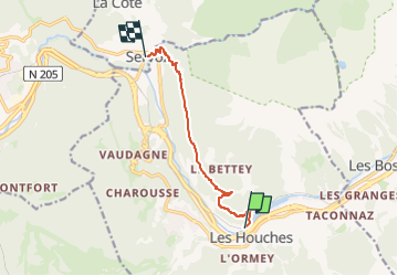
Ruta Senderismo de 7,5 km a descubrir en Auvergne-Rhône-Alpes, Alta Saboya, Les Houches. Esta ruta ha sido propuesta por mumu.larandonneuse.
Descripción
Montée depuis la Gare des Houches sur le versant de Coupeau, sentier en balcon qui surplombe Les Houches, en redescendant vers le village de Servoz.
Départ : Dans le 2ème virage de la route de Coupeau, suivre la direction le Bettey/la Flatière. Au-dessus du lieu-dit-Morand, avant d'atteindre le Bettey, bifurquer sur la gauche en direction de Montvauthier et, de ce hameau redescendre sur Servoz.
Durée : 3h A/R
Le retour aux Houches peut se faire en voiture ou en train (depuis la gare de Servoz)
Accès au sentier soumis aux conditions météorologiques. Pour plus d’informations, contacter l’Office de Haute Montagne de Chamonix : 33 (0)4 50 53 22 08.
ℹ️ https://www.savoie-mont-blanc.com/randonnees-et-balades/randonnee-coupeau-servoz-87515/
.
Localización
Comentarios
Excursiones cerca
![Excursión Senderismo Chamonix-Mont-Blanc - J8 - Cascade du Dard - Photo](https://media.geolcdn.com/t/375/260/c145d485-4f6a-4304-96f9-70fb8a7d1c29.jpg&format=jpg&maxdim=2)
![Senderismo Senderismo](https://static1.geolcdn.com/sitytour/trail-icons/101.png)
Senderismo
![](/images/other/stat-length.png)
![](https://static1.geolcdn.com/siteimages/upload/files/16400158638029165_repeat_loop_refresh_sync_direction_icon.png)
![Excursión Senderismo Les Houches - J4 - Les Chavants - Charousse - Vaudagne - Photo](https://media.geolcdn.com/t/375/260/d3179e8d-4a15-42b5-a258-50d7450d9242.jpg&format=jpg&maxdim=2)
![Senderismo Senderismo](https://static1.geolcdn.com/sitytour/trail-icons/101.png)
Senderismo
![](/images/other/stat-length.png)
![](https://static1.geolcdn.com/siteimages/upload/files/16400158638029165_repeat_loop_refresh_sync_direction_icon.png)
![Excursión Senderismo Les Houches - 2024-05-29_17h11m02_christ-roi - Photo](https://media.geolcdn.com/t/375/260/5a9858e2-48aa-4c94-bd12-4c66dc77167c.jpg&format=jpg&maxdim=2)
![Senderismo Senderismo](https://static1.geolcdn.com/sitytour/trail-icons/101.png)
Senderismo
![](/images/other/stat-length.png)
![](https://static1.geolcdn.com/siteimages/upload/files/16400158638029165_repeat_loop_refresh_sync_direction_icon.png)
![Excursión Senderismo Chamonix-Mont-Blanc - Glacier des Bossons Les Houches Chamonix - Photo](https://media.geolcdn.com/t/375/260/ext.jpg?maxdim=2&url=https%3A%2F%2Fservices.sitytrail.com%2FGeolivesWS%2FDownloadMedia.ashx%3FTrailID%3D118854%26Media%3D13070_2.jpg)
![Senderismo Senderismo](https://static1.geolcdn.com/sitytour/trail-icons/101.png)
Senderismo
![](/images/other/stat-length.png)
![](https://static1.geolcdn.com/siteimages/upload/files/16400158638029165_repeat_loop_refresh_sync_direction_icon.png)
![Excursión Senderismo Chamonix-Mont-Blanc - Chalet des Pyramides 1895m 11.7.22 - Photo](https://media.geolcdn.com/t/375/260/ef1bf2d0-a858-40af-bcf2-b4e7d382c27f.jpg&format=jpg&maxdim=2)
![Senderismo Senderismo](https://static1.geolcdn.com/sitytour/trail-icons/101.png)
Senderismo
![](/images/other/stat-length.png)
![](https://static1.geolcdn.com/siteimages/upload/files/16400158638029165_repeat_loop_refresh_sync_direction_icon.png)
![Excursión Senderismo Chamonix-Mont-Blanc - La cascade du dard - Photo](https://media.geolcdn.com/t/375/260/ext.jpg?maxdim=2&url=https%3A%2F%2Fservices.sitytrail.com%2FGeolivesWS%2FDownloadMedia.ashx%3FTrailID%3D626685%26Media%3D433ceacd-297f-461a-afa3-69d034da6405.jpg)
![Senderismo Senderismo](https://static1.geolcdn.com/sitytour/trail-icons/101.png)
Senderismo
![](/images/other/stat-length.png)
![](https://static1.geolcdn.com/siteimages/upload/files/16400158638029165_repeat_loop_refresh_sync_direction_icon.png)
![Excursión Senderismo Les Houches - Chalets de Charlousse - Photo](https://media.geolcdn.com/t/375/260/ext.jpg?maxdim=2&url=https%3A%2F%2Fstatic1.geolcdn.com%2Fsiteimages%2Fupload%2Ffiles%2F1553511878bg_sport_marche.png)
![Senderismo Senderismo](https://static1.geolcdn.com/sitytour/trail-icons/101.png)
Senderismo
![](/images/other/stat-length.png)
![](https://static1.geolcdn.com/siteimages/upload/files/16400158638029165_repeat_loop_refresh_sync_direction_icon.png)
![Excursión Senderismo Saint-Gervais-les-Bains - Descente au Glacier de Bionnassay depuis le Nid d''Aigle - Photo](https://media.geolcdn.com/t/375/260/ext.jpg?maxdim=2&url=https%3A%2F%2Fstatic1.geolcdn.com%2Fsiteimages%2Fupload%2Ffiles%2F1553511878bg_sport_marche.png)
![Senderismo Senderismo](https://static1.geolcdn.com/sitytour/trail-icons/101.png)
Senderismo
![](/images/other/stat-length.png)
![](https://static1.geolcdn.com/siteimages/upload/files/16400158638029165_repeat_loop_refresh_sync_direction_icon.png)
![Excursión Senderismo Chamonix-Mont-Blanc - J24 - R24 - Cascade du Dard - Lac des Gaillands
- Photo](https://media.geolcdn.com/t/375/260/4b1b26de-b7bc-455f-9a33-11007d9d891c.jpg&format=jpg&maxdim=2)
![Senderismo Senderismo](https://static1.geolcdn.com/sitytour/trail-icons/101.png)
Senderismo
![](/images/other/stat-length.png)
![](https://static1.geolcdn.com/siteimages/upload/files/16400158638029165_repeat_loop_refresh_sync_direction_icon.png)