![](/images/other/stat-length.png)
![Excursión Senderismo Les Houches - 2024-05-29_14h37m29_merlet+-+plan+la+cry - Photo](https://media.geolcdn.com/t/1900/400/ext.pjpeg?maxdim=2&url=https%3A%2F%2Fstatic1.geolcdn.com%2Fsiteimages%2Fupload%2Ffiles%2F1553511878bg_sport_marche.png)
2024-05-29_14h37m29_merlet+-+plan+la+cry
mumu.larandonneuse
Usuario GUIDE
![Longitud](/images/other/stat-length.png)
![Altitud máxima](https://static1.geolcdn.com/siteimages/upload/files/1508320355ic_sort_altitude_max_24dp.png)
![Desnivel positivo](https://static1.geolcdn.com/siteimages/upload/files/1508320355ic_sort_den_pos_24dp.png)
![Km-Effort](/images/other/stat-length.png)
![Altitud mínima](https://static1.geolcdn.com/siteimages/upload/files/1508320355ic_sort_altitude_min_24dp.png)
![Desnivel negativo](https://static1.geolcdn.com/siteimages/upload/files/1508320355ic_sort_den_neg_24dp.png)
![Boucle](https://static1.geolcdn.com/siteimages/upload/files/16400158638029165_repeat_loop_refresh_sync_direction_icon.png)
![Senderismo](https://static1.geolcdn.com/sitytour/trail-icons/101.png)
1h13
Dificultad : Fácil
![Escanee este código QR para abrir la excursión en la aplicación SityTrail](https://capi.geolives.com/qq0zvz2zws4bq2lad0pu/sitytour/trails/4072330/qr.png?size=200)
Aplicación GPS de excursión GRATIS
A propósito
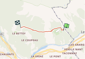
Ruta Senderismo de 3,1 km a descubrir en Auvergne-Rhône-Alpes, Alta Saboya, Les Houches. Esta ruta ha sido propuesta por mumu.larandonneuse.
Descripción
Randonnée la plupart du temps en sous bois. Parcours panoramique face au massif du Mont Blanc.
De l’entrée du parc, remonter à droite Ie long des grillages et prendre sur la droite durant 10 mn le sentier de Bel-Lachat et Brévent. L’abandonner et à gauche partir à l’horizontale sur 400 m. Descendre en laissant sur la droite le sentier de Chailloux. Quelques lacets dans la pente conduisent à une bifurcation : laisser à gauche le sentier des Houches et prendre celui qui part horizontalement à droite dans la forêt. Il passe un peu en-dessous du Lac Noir et rejoint le Plan de la Cry.
Possibilité de partir des Houches, des Bossons ou de Chamonix.
Plus de renseignements disponibles à l'Office de Tourisme ou l'Office de Haute-Montagne et dans notre guide sentiers.
Attention : Les conditions des sentiers sont susceptibles de changer, pensez à vous renseigner avant de partir.
ℹ️ https://www.savoie-mont-blanc.com/randonnees-et-balades/petit-balcon-sud-merlet-plan-de-la-cry-87402/
.
Localización
Comentarios
Excursiones cerca
![Excursión Senderismo Chamonix-Mont-Blanc - J8 - Cascade du Dard - Photo](https://media.geolcdn.com/t/375/260/c145d485-4f6a-4304-96f9-70fb8a7d1c29.jpg&format=jpg&maxdim=2)
![Senderismo Senderismo](https://static1.geolcdn.com/sitytour/trail-icons/101.png)
Senderismo
![](/images/other/stat-length.png)
![](https://static1.geolcdn.com/siteimages/upload/files/16400158638029165_repeat_loop_refresh_sync_direction_icon.png)
![Excursión Senderismo Les Houches - J4 - Les Chavants - Charousse - Vaudagne - Photo](https://media.geolcdn.com/t/375/260/d3179e8d-4a15-42b5-a258-50d7450d9242.jpg&format=jpg&maxdim=2)
![Senderismo Senderismo](https://static1.geolcdn.com/sitytour/trail-icons/101.png)
Senderismo
![](/images/other/stat-length.png)
![](https://static1.geolcdn.com/siteimages/upload/files/16400158638029165_repeat_loop_refresh_sync_direction_icon.png)
![Excursión Senderismo Les Houches - 2024-05-29_17h11m02_christ-roi - Photo](https://media.geolcdn.com/t/375/260/5a9858e2-48aa-4c94-bd12-4c66dc77167c.jpg&format=jpg&maxdim=2)
![Senderismo Senderismo](https://static1.geolcdn.com/sitytour/trail-icons/101.png)
Senderismo
![](/images/other/stat-length.png)
![](https://static1.geolcdn.com/siteimages/upload/files/16400158638029165_repeat_loop_refresh_sync_direction_icon.png)
![Excursión Carrera Chamonix-Mont-Blanc - The North Face© Ultra Trail du Mont-Blanc© UTMB 2008 - Photo](https://media.geolcdn.com/t/375/260/ext.jpg?maxdim=2&url=https%3A%2F%2Fservices.sitytrail.com%2FGeolivesWS%2FDownloadMedia.ashx%3FTrailID%3D109134%26Media%3D3174_5.jpg)
![Carrera Carrera](https://static1.geolcdn.com/sitytour/trail-icons/103.png)
Carrera
![](/images/other/stat-length.png)
![](https://static1.geolcdn.com/siteimages/upload/files/16400158638029165_repeat_loop_refresh_sync_direction_icon.png)
![Excursión Senderismo Chamonix-Mont-Blanc - Circuit de la Mer de Glace - Chamonix Mont Blanc - Photo](https://media.geolcdn.com/t/375/260/ext.jpg?maxdim=2&url=https%3A%2F%2Fservices.sitytrail.com%2FGeolivesWS%2FDownloadMedia.ashx%3FTrailID%3D103700%26Media%3D6192_6.jpg)
![Senderismo Senderismo](https://static1.geolcdn.com/sitytour/trail-icons/101.png)
Senderismo
![](/images/other/stat-length.png)
![](https://static1.geolcdn.com/siteimages/upload/files/16400158638029165_repeat_loop_refresh_sync_direction_icon.png)
![Excursión Senderismo Chamonix-Mont-Blanc - Glacier des Bossons Les Houches Chamonix - Photo](https://media.geolcdn.com/t/375/260/ext.jpg?maxdim=2&url=https%3A%2F%2Fservices.sitytrail.com%2FGeolivesWS%2FDownloadMedia.ashx%3FTrailID%3D118854%26Media%3D13070_2.jpg)
![Senderismo Senderismo](https://static1.geolcdn.com/sitytour/trail-icons/101.png)
Senderismo
![](/images/other/stat-length.png)
![](https://static1.geolcdn.com/siteimages/upload/files/16400158638029165_repeat_loop_refresh_sync_direction_icon.png)
![Excursión Senderismo Chamonix-Mont-Blanc - Chalet des Pyramides 1895m 11.7.22 - Photo](https://media.geolcdn.com/t/375/260/ef1bf2d0-a858-40af-bcf2-b4e7d382c27f.jpg&format=jpg&maxdim=2)
![Senderismo Senderismo](https://static1.geolcdn.com/sitytour/trail-icons/101.png)
Senderismo
![](/images/other/stat-length.png)
![](https://static1.geolcdn.com/siteimages/upload/files/16400158638029165_repeat_loop_refresh_sync_direction_icon.png)
![Excursión Senderismo Chamonix-Mont-Blanc - La cascade du dard - Photo](https://media.geolcdn.com/t/375/260/ext.jpg?maxdim=2&url=https%3A%2F%2Fservices.sitytrail.com%2FGeolivesWS%2FDownloadMedia.ashx%3FTrailID%3D626685%26Media%3D433ceacd-297f-461a-afa3-69d034da6405.jpg)
![Senderismo Senderismo](https://static1.geolcdn.com/sitytour/trail-icons/101.png)
Senderismo
![](/images/other/stat-length.png)
![](https://static1.geolcdn.com/siteimages/upload/files/16400158638029165_repeat_loop_refresh_sync_direction_icon.png)
![Excursión Senderismo Chamonix-Mont-Blanc - Le lac bleus - Photo](https://media.geolcdn.com/t/375/260/ext.jpg?maxdim=2&url=https%3A%2F%2Fservices.sitytrail.com%2FGeolivesWS%2FDownloadMedia.ashx%3FTrailID%3D467938%26Media%3D0e0140a2-6104-42dc-addc-29be79b70aa4.jpg)
![Senderismo Senderismo](https://static1.geolcdn.com/sitytour/trail-icons/101.png)
Senderismo
![](/images/other/stat-length.png)
![](https://static1.geolcdn.com/siteimages/upload/files/16400158638029165_repeat_loop_refresh_sync_direction_icon.png)