![](/images/other/stat-length.png)
![Excursión Senderismo Saint-Gervais-les-Bains - 2024-05-29_14h23m19_Bellevue-+Prarion - Photo](https://media.geolcdn.com/t/1900/400/ext.pjpeg?maxdim=2&url=https%3A%2F%2Fstatic1.geolcdn.com%2Fsiteimages%2Fupload%2Ffiles%2F1553511878bg_sport_marche.png)
2024-05-29_14h23m19_Bellevue-+Prarion
mumu.larandonneuse
Usuario GUIDE
![Longitud](/images/other/stat-length.png)
![Altitud máxima](https://static1.geolcdn.com/siteimages/upload/files/1508320355ic_sort_altitude_max_24dp.png)
![Desnivel positivo](https://static1.geolcdn.com/siteimages/upload/files/1508320355ic_sort_den_pos_24dp.png)
![Km-Effort](/images/other/stat-length.png)
![Altitud mínima](https://static1.geolcdn.com/siteimages/upload/files/1508320355ic_sort_altitude_min_24dp.png)
![Desnivel negativo](https://static1.geolcdn.com/siteimages/upload/files/1508320355ic_sort_den_neg_24dp.png)
![Boucle](https://static1.geolcdn.com/siteimages/upload/files/16400158638029165_repeat_loop_refresh_sync_direction_icon.png)
![Senderismo](https://static1.geolcdn.com/sitytour/trail-icons/101.png)
1h18
Dificultad : Fácil
![Escanee este código QR para abrir la excursión en la aplicación SityTrail](https://capi.geolives.com/qq0zvz2zws4bq2lad0pu/sitytour/trails/4072298/qr.png?size=200)
Aplicación GPS de excursión GRATIS
A propósito
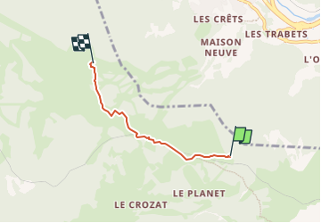
Ruta Senderismo de 3,3 km a descubrir en Auvergne-Rhône-Alpes, Alta Saboya, Saint-Gervais-les-Bains. Esta ruta ha sido propuesta por mumu.larandonneuse.
Descripción
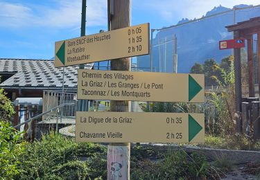
À la sortie du téléphérique, descendre à gauche sous l’ancien hôtel de Bellevue,
vue sur les Aiguilles de Bionnassay et du Goûter, en longeant la voie ferrée
du Tramway du Mont-Blanc. En dessous, à droite, un alpage toujours utilisé.
Rejoindre le Col de Voza (1 653 m). Suivre le chemin qui part sur la droite et qui
monte vers l’Hôtel du Prarion et la gare de télécabine LHSG (1 853 m).
Possible de partir des Houches.
Plus de renseignements disponibles à l'Office de Tourisme ou l'Office de Haute-Montagne et dans notre guide sentier.
Attention : Les conditions des sentiers sont susceptibles de changer, pensez à vous renseigner avant de partir.
ℹ️ https://www.savoie-mont-blanc.com/randonnees-et-balades/grand-balcon-nord-bellevue-prarion-77006/
.
Localización
Comentarios
Excursiones cerca
![Excursión Senderismo Les Houches - J4 - Les Chavants - Charousse - Vaudagne - Photo](https://media.geolcdn.com/t/375/260/d3179e8d-4a15-42b5-a258-50d7450d9242.jpg&format=jpg&maxdim=2)
![Senderismo Senderismo](https://static1.geolcdn.com/sitytour/trail-icons/101.png)
Senderismo
![](/images/other/stat-length.png)
![](https://static1.geolcdn.com/siteimages/upload/files/16400158638029165_repeat_loop_refresh_sync_direction_icon.png)
![Excursión Senderismo Les Houches - 2024-05-29_17h11m02_christ-roi - Photo](https://media.geolcdn.com/t/375/260/5a9858e2-48aa-4c94-bd12-4c66dc77167c.jpg&format=jpg&maxdim=2)
![Senderismo Senderismo](https://static1.geolcdn.com/sitytour/trail-icons/101.png)
Senderismo
![](/images/other/stat-length.png)
![](https://static1.geolcdn.com/siteimages/upload/files/16400158638029165_repeat_loop_refresh_sync_direction_icon.png)
![Excursión Senderismo Chamonix-Mont-Blanc - Glacier des Bossons Les Houches Chamonix - Photo](https://media.geolcdn.com/t/375/260/ext.jpg?maxdim=2&url=https%3A%2F%2Fservices.sitytrail.com%2FGeolivesWS%2FDownloadMedia.ashx%3FTrailID%3D118854%26Media%3D13070_2.jpg)
![Senderismo Senderismo](https://static1.geolcdn.com/sitytour/trail-icons/101.png)
Senderismo
![](/images/other/stat-length.png)
![](https://static1.geolcdn.com/siteimages/upload/files/16400158638029165_repeat_loop_refresh_sync_direction_icon.png)
![Excursión Senderismo Les Houches - Chalets de Charlousse - Photo](https://media.geolcdn.com/t/375/260/ext.jpg?maxdim=2&url=https%3A%2F%2Fstatic1.geolcdn.com%2Fsiteimages%2Fupload%2Ffiles%2F1553511878bg_sport_marche.png)
![Senderismo Senderismo](https://static1.geolcdn.com/sitytour/trail-icons/101.png)
Senderismo
![](/images/other/stat-length.png)
![](https://static1.geolcdn.com/siteimages/upload/files/16400158638029165_repeat_loop_refresh_sync_direction_icon.png)
![Excursión Senderismo Saint-Gervais-les-Bains - Descente au Glacier de Bionnassay depuis le Nid d''Aigle - Photo](https://media.geolcdn.com/t/375/260/ext.jpg?maxdim=2&url=https%3A%2F%2Fstatic1.geolcdn.com%2Fsiteimages%2Fupload%2Ffiles%2F1553511878bg_sport_marche.png)
![Senderismo Senderismo](https://static1.geolcdn.com/sitytour/trail-icons/101.png)
Senderismo
![](/images/other/stat-length.png)
![](https://static1.geolcdn.com/siteimages/upload/files/16400158638029165_repeat_loop_refresh_sync_direction_icon.png)
![Excursión Senderismo Saint-Gervais-les-Bains - J17 - R16 - Le Plan de la Croix - Bettex - Photo](https://media.geolcdn.com/t/375/260/9e9bfba6-47e3-4d79-973a-bad9115a8891.jpg&format=jpg&maxdim=2)
![Senderismo Senderismo](https://static1.geolcdn.com/sitytour/trail-icons/101.png)
Senderismo
![](/images/other/stat-length.png)
![](https://static1.geolcdn.com/siteimages/upload/files/16400158638029165_repeat_loop_refresh_sync_direction_icon.png)
![Excursión Senderismo Saint-Gervais-les-Bains - J15 - R14 - Bellevue - Col de Voza - Bionnassay - Le Planet - L'Are - Photo](https://media.geolcdn.com/t/375/260/fc549d5f-f6ec-4493-a049-baace26efb0f.jpg&format=jpg&maxdim=2)
![Senderismo Senderismo](https://static1.geolcdn.com/sitytour/trail-icons/101.png)
Senderismo
![](/images/other/stat-length.png)
![](https://static1.geolcdn.com/siteimages/upload/files/16400158638029165_repeat_loop_refresh_sync_direction_icon.png)
![Excursión Senderismo Saint-Gervais-les-Bains - J8 - Grand Balcon Nord : Prarion - Bellevue - Photo](https://media.geolcdn.com/t/375/260/e297f14e-0df1-408d-aab5-9a3949be4ac4.jpg&format=jpg&maxdim=2)
![Senderismo Senderismo](https://static1.geolcdn.com/sitytour/trail-icons/101.png)
Senderismo
![](/images/other/stat-length.png)
![](https://static1.geolcdn.com/siteimages/upload/files/16400158638029165_repeat_loop_refresh_sync_direction_icon.png)
![Excursión Senderismo Les Houches - J7 - Les Houches > Chamonix par le Chemin des Villages - Photo](https://media.geolcdn.com/t/375/260/8bb7d9dc-96a2-4ef0-a910-22de31540a90.jpg&format=jpg&maxdim=2)
![Senderismo Senderismo](https://static1.geolcdn.com/sitytour/trail-icons/101.png)
Senderismo
![](/images/other/stat-length.png)
![](https://static1.geolcdn.com/siteimages/upload/files/16400158638029165_repeat_loop_refresh_sync_direction_icon.png)