![](/images/other/stat-length.png)
![Excursión Senderismo Monnetier-Mornex - sentier de la Sauge - Photo](https://media.geolcdn.com/t/1900/400/c35518be-b219-456a-b639-b0d81d9789ec.jpg&format=pjpeg&maxdim=2)
sentier de la Sauge
perenhout
Usuario
![Longitud](/images/other/stat-length.png)
![Altitud máxima](https://static1.geolcdn.com/siteimages/upload/files/1508320355ic_sort_altitude_max_24dp.png)
![Desnivel positivo](https://static1.geolcdn.com/siteimages/upload/files/1508320355ic_sort_den_pos_24dp.png)
![Km-Effort](/images/other/stat-length.png)
![Altitud mínima](https://static1.geolcdn.com/siteimages/upload/files/1508320355ic_sort_altitude_min_24dp.png)
![Desnivel negativo](https://static1.geolcdn.com/siteimages/upload/files/1508320355ic_sort_den_neg_24dp.png)
![Boucle](https://static1.geolcdn.com/siteimages/upload/files/16400158638029165_repeat_loop_refresh_sync_direction_icon.png)
![Senderismo](https://static1.geolcdn.com/sitytour/trail-icons/101.png)
3h43
Dificultad : Medio
![Escanee este código QR para abrir la excursión en la aplicación SityTrail](https://capi.geolives.com/qq0zvz2zws4bq2lad0pu/sitytour/trails/4067375/qr.png?size=200)
Aplicación GPS de excursión GRATIS
A propósito
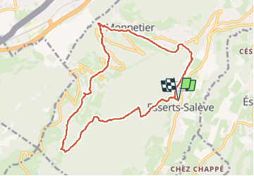
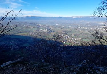
Ruta Senderismo de 9,6 km a descubrir en Auvergne-Rhône-Alpes, Alta Saboya, Monnetier-Mornex. Esta ruta ha sido propuesta por perenhout .
Descripción
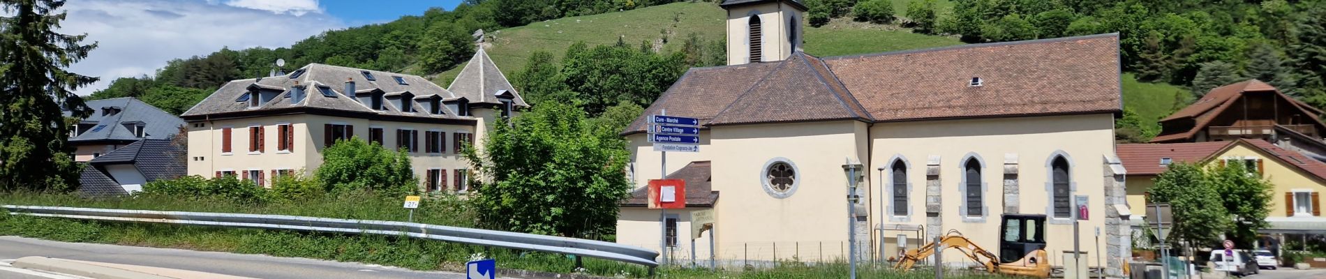
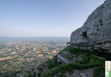
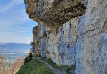
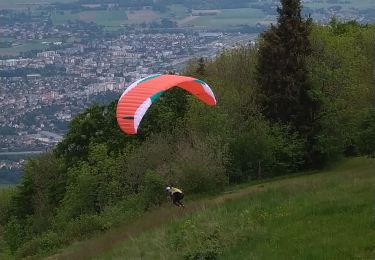
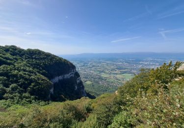
Parking d'Esserts-Salève, devant la mairie. On monte jusqu'à Grange Gaby, dans la forêt. En haut les contreforts du Saève sont magnifiques. Retour par le balcon du Léman (magnifique point de vue là où le chemin revient vers l'ouest).
Localización
Comentarios
Excursiones cerca
![Excursión Senderismo Monnetier-Mornex - Salève, circuit par la vire de la Corraterie - Photo](https://media.geolcdn.com/t/375/260/ext.jpg?maxdim=2&url=https%3A%2F%2Fservices.sitytrail.com%2FGeolivesWS%2FDownloadMedia.ashx%3FTrailID%3D172408%26Media%3D13754_1.jpg)
![Senderismo Senderismo](https://static1.geolcdn.com/sitytour/trail-icons/101.png)
Senderismo
![](/images/other/stat-length.png)
![](https://static1.geolcdn.com/siteimages/upload/files/16400158638029165_repeat_loop_refresh_sync_direction_icon.png)
![Excursión A pie Veyrier - Eaux d'Arve - Pinchat - Photo](https://media.geolcdn.com/t/375/260/01df3976-cbc6-4733-8377-6a29e56e0add.jpeg&format=jpg&maxdim=2)
![A pie A pie](https://static1.geolcdn.com/sitytour/trail-icons/100.png)
A pie
![](/images/other/stat-length.png)
![](https://static1.geolcdn.com/siteimages/upload/files/16400158638029165_repeat_loop_refresh_sync_direction_icon.png)
![Excursión Senderismo Collonges-sous-Salève - Le Coin-Grottes d'Orjobet-La Corraterie-Grande Gorge-Le Coin - Photo](https://media.geolcdn.com/t/375/260/aabf5e02-cc0c-4aa0-939a-41b03f824e1c.jpg&format=jpg&maxdim=2)
![Senderismo Senderismo](https://static1.geolcdn.com/sitytour/trail-icons/101.png)
Senderismo
![](/images/other/stat-length.png)
![](https://static1.geolcdn.com/siteimages/upload/files/16400158638029165_repeat_loop_refresh_sync_direction_icon.png)
![Excursión Senderismo Étrembières - Château Etrembières-Les Voûtes-Salève Observatoire - Photo](https://media.geolcdn.com/t/375/260/015a4621-3968-42ed-9ea3-83173bd5ccbc.jpg&format=jpg&maxdim=2)
![Senderismo Senderismo](https://static1.geolcdn.com/sitytour/trail-icons/101.png)
Senderismo
![](/images/other/stat-length.png)
![](https://static1.geolcdn.com/siteimages/upload/files/16400158638029165_repeat_loop_refresh_sync_direction_icon.png)
![Excursión Senderismo La Muraz - La Croisette - Téléphérique - Photo](https://media.geolcdn.com/t/375/260/bbb7530c-646b-4278-a608-5976a2ccf5a8.jpg&format=jpg&maxdim=2)
![Senderismo Senderismo](https://static1.geolcdn.com/sitytour/trail-icons/101.png)
Senderismo
![](/images/other/stat-length.png)
![](https://static1.geolcdn.com/siteimages/upload/files/16400158638029165_repeat_loop_refresh_sync_direction_icon.png)
![Excursión Senderismo Collonges-sous-Salève - Le Salève en boucle, orjobet , corraterie, belvédère, grande gorge - Photo](https://media.geolcdn.com/t/375/260/201bd548-abfc-4c16-8a26-ab36aa21dc20.jpg&format=jpg&maxdim=2)
![Senderismo Senderismo](https://static1.geolcdn.com/sitytour/trail-icons/101.png)
Senderismo
![](/images/other/stat-length.png)
![](https://static1.geolcdn.com/siteimages/upload/files/16400158638029165_repeat_loop_refresh_sync_direction_icon.png)
![Excursión Senderismo Collonges-sous-Salève - SALEVE - Photo](https://media.geolcdn.com/t/375/260/7cbc3f40-5ee2-427e-bcb6-ff3543321705.jpg&format=jpg&maxdim=2)
![Senderismo Senderismo](https://static1.geolcdn.com/sitytour/trail-icons/101.png)
Senderismo
![](/images/other/stat-length.png)
![](https://static1.geolcdn.com/siteimages/upload/files/16400158638029165_repeat_loop_refresh_sync_direction_icon.png)
![Excursión Senderismo Collonges-sous-Salève - GRAND SALEVE: GROTTES ET SENTIER-BALCON - Photo](https://media.geolcdn.com/t/375/260/254bcac5-a0fe-43c3-a1c2-202e25644106.jpg&format=jpg&maxdim=2)
![Senderismo Senderismo](https://static1.geolcdn.com/sitytour/trail-icons/101.png)
Senderismo
![](/images/other/stat-length.png)
![](https://static1.geolcdn.com/siteimages/upload/files/16400158638029165_repeat_loop_refresh_sync_direction_icon.png)
![Excursión Bici de montaña Reignier-Ésery - les Bornes 11 aout 31km - Photo](https://media.geolcdn.com/t/375/260/ext.jpg?maxdim=2&url=https%3A%2F%2Fstatic1.geolcdn.com%2Fsiteimages%2Fupload%2Ffiles%2F1524743154velo.jpg)
![Bici de montaña Bici de montaña](https://static1.geolcdn.com/sitytour/trail-icons/202.png)
Bici de montaña
![](/images/other/stat-length.png)
![](https://static1.geolcdn.com/siteimages/upload/files/16400158638029165_repeat_loop_refresh_sync_direction_icon.png)