![](/images/other/stat-length.png)
![Excursión Senderismo Mont-Saxonnex - lac bénit col de cévise la glacière - Photo](https://media.geolcdn.com/t/1900/400/ext.pjpeg?maxdim=2&url=https%3A%2F%2Fstatic1.geolcdn.com%2Fsiteimages%2Fupload%2Ffiles%2F1553511878bg_sport_marche.png)
lac bénit col de cévise la glacière
Montagne71
Usuario
![Longitud](/images/other/stat-length.png)
Longitud
24 km
![Altitud máxima](https://static1.geolcdn.com/siteimages/upload/files/1508320355ic_sort_altitude_max_24dp.png)
Altitud máxima
1767 m
![Desnivel positivo](https://static1.geolcdn.com/siteimages/upload/files/1508320355ic_sort_den_pos_24dp.png)
Desnivel positivo
1218 m
![Km-Effort](/images/other/stat-length.png)
Km-Effort
40 km
![Altitud mínima](https://static1.geolcdn.com/siteimages/upload/files/1508320355ic_sort_altitude_min_24dp.png)
Altitud mínima
957 m
![Desnivel negativo](https://static1.geolcdn.com/siteimages/upload/files/1508320355ic_sort_den_neg_24dp.png)
Desnivel negativo
1220 m
![Boucle](https://static1.geolcdn.com/siteimages/upload/files/16400158638029165_repeat_loop_refresh_sync_direction_icon.png)
Boucle
Sí
Fecha de creación :
2024-05-10 07:01:05.406
Última modificación :
2024-05-10 16:22:26.819
![Senderismo](https://static1.geolcdn.com/sitytour/trail-icons/101.png)
9h20
Dificultad : Medio
![Escanee este código QR para abrir la excursión en la aplicación SityTrail](https://capi.geolives.com/qq0zvz2zws4bq2lad0pu/sitytour/trails/4049435/qr.png?size=200)
Aplicación GPS de excursión GRATIS
A propósito
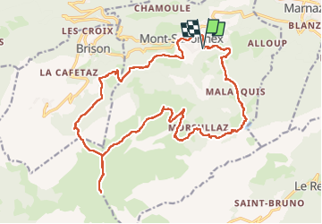
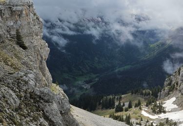
Ruta Senderismo de 24 km a descubrir en Auvergne-Rhône-Alpes, Alta Saboya, Mont-Saxonnex. Esta ruta ha sido propuesta por Montagne71.
Descripción
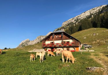
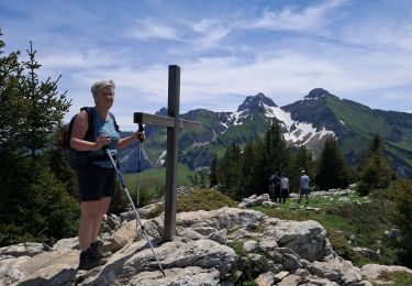
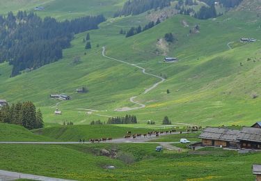
belle rando, beau temps, jolie descente sur la glacière, avec chaînes passage techniques.
Localización
País:
France
Región :
Auvergne-Rhône-Alpes
Departamento/provincia :
Alta Saboya
Municipio :
Mont-Saxonnex
Localidad:
Unknown
Salida:(Dec)
Salida:(UTM)
305636 ; 5102463 (32T) N.
Comentarios
Excursiones cerca
![Excursión Senderismo Glières-Val-de-Borne - BARGY: ROCHERS DE LESCHAUX AU DEPART DE CENISE - Photo](https://media.geolcdn.com/t/375/260/5ac05f8e-3735-47a8-a18c-c0c850908ba7.jpg&format=jpg&maxdim=2)
![Senderismo Senderismo](https://static1.geolcdn.com/sitytour/trail-icons/101.png)
BARGY: ROCHERS DE LESCHAUX AU DEPART DE CENISE
Senderismo
Medio
(1)
Glières-Val-de-Borne,
Auvergne-Rhône-Alpes,
Alta Saboya,
France
![](/images/other/stat-length.png)
9,7 km | 15,3 km-effort
3h 30min
![](https://static1.geolcdn.com/siteimages/upload/files/16400158638029165_repeat_loop_refresh_sync_direction_icon.png)
Sí
![Excursión Senderismo Le Reposoir - Le Petit Bargy 2098 m, depuis Malatrait - Photo](https://media.geolcdn.com/t/375/260/ext.jpg?maxdim=2&url=https%3A%2F%2Fservices.sitytrail.com%2FGeolivesWS%2FDownloadMedia.ashx%3FTrailID%3D215073%26Media%3D15647_1.jpg)
![Senderismo Senderismo](https://static1.geolcdn.com/sitytour/trail-icons/101.png)
Le Petit Bargy 2098 m, depuis Malatrait
Senderismo
Medio
(1)
Le Reposoir,
Auvergne-Rhône-Alpes,
Alta Saboya,
France
![](/images/other/stat-length.png)
8,1 km | 18,8 km-effort
5h 0min
![](https://static1.geolcdn.com/siteimages/upload/files/16400158638029165_repeat_loop_refresh_sync_direction_icon.png)
Sí
![Excursión Senderismo Mont-Saxonnex - Les Rochers de Leschaux, 1936m - Mont Saxonex - Photo](https://media.geolcdn.com/t/375/260/ext.jpg?maxdim=2&url=https%3A%2F%2Fservices.sitytrail.com%2FGeolivesWS%2FDownloadMedia.ashx%3FTrailID%3D172447%26Media%3D13800_1.jpg)
![Senderismo Senderismo](https://static1.geolcdn.com/sitytour/trail-icons/101.png)
Les Rochers de Leschaux, 1936m - Mont Saxonex
Senderismo
Medio
(1)
Mont-Saxonnex,
Auvergne-Rhône-Alpes,
Alta Saboya,
France
![](/images/other/stat-length.png)
11,6 km | 20 km-effort
5h 0min
![](https://static1.geolcdn.com/siteimages/upload/files/16400158638029165_repeat_loop_refresh_sync_direction_icon.png)
Sí
![Excursión Esquí de fondo Glières-Val-de-Borne - Tour du Jallouvre par le lac de Lessy - Photo](https://media.geolcdn.com/t/375/260/1d705345-d276-40a8-b673-92ff954efff5.jpg&format=jpg&maxdim=2)
![Esquí de fondo Esquí de fondo](https://static1.geolcdn.com/sitytour/trail-icons/503.png)
Tour du Jallouvre par le lac de Lessy
Esquí de fondo
Difícil
Glières-Val-de-Borne,
Auvergne-Rhône-Alpes,
Alta Saboya,
France
![](/images/other/stat-length.png)
14,3 km | 37 km-effort
6h 39min
![](https://static1.geolcdn.com/siteimages/upload/files/16400158638029165_repeat_loop_refresh_sync_direction_icon.png)
Sí
![Excursión Esquí de fondo Glières-Val-de-Borne - col du rasoir combe NW ET Sud - Photo](https://media.geolcdn.com/t/375/260/c51ae7d8-65f2-4ba4-b4a6-8cbff7bf96a0.jpg&format=jpg&maxdim=2)
![Esquí de fondo Esquí de fondo](https://static1.geolcdn.com/sitytour/trail-icons/503.png)
col du rasoir combe NW ET Sud
Esquí de fondo
Medio
Glières-Val-de-Borne,
Auvergne-Rhône-Alpes,
Alta Saboya,
France
![](/images/other/stat-length.png)
11,1 km | 29 km-effort
5h 2min
![](https://static1.geolcdn.com/siteimages/upload/files/16400158638029165_repeat_loop_refresh_sync_direction_icon.png)
Sí
![Excursión Senderismo Le Reposoir - Montée au Petit Bargy - Photo](https://media.geolcdn.com/t/375/260/ea6ece50-61df-4c47-8f5e-dbac60c23bae.jpg&format=jpg&maxdim=2)
![Senderismo Senderismo](https://static1.geolcdn.com/sitytour/trail-icons/101.png)
Montée au Petit Bargy
Senderismo
Difícil
Le Reposoir,
Auvergne-Rhône-Alpes,
Alta Saboya,
France
![](/images/other/stat-length.png)
10,4 km | 23 km-effort
4h 1min
![](https://static1.geolcdn.com/siteimages/upload/files/16400158638029165_repeat_loop_refresh_sync_direction_icon.png)
Sí
![Excursión Senderismo Brizon - BARGY: SOLAISON - CENISE par le](https://media.geolcdn.com/t/375/260/8d99e16f-5dc8-4624-b531-7bcb887f7aec.jpg&format=jpg&maxdim=2)
![Senderismo Senderismo](https://static1.geolcdn.com/sitytour/trail-icons/101.png)
BARGY: SOLAISON - CENISE par le "mauvais pas" - ROCHERS DE LESCHAUX - SOLAISO...
Senderismo
Medio
Brizon,
Auvergne-Rhône-Alpes,
Alta Saboya,
France
![](/images/other/stat-length.png)
7 km | 13,2 km-effort
3h 0min
![](https://static1.geolcdn.com/siteimages/upload/files/16400158638029165_repeat_loop_refresh_sync_direction_icon.png)
Sí
![Excursión Senderismo Le Reposoir - Col des Annes du Reposoir - Photo](https://media.geolcdn.com/t/375/260/bcc438bd-81aa-4865-839b-0c5618bef2fb.jpg&format=jpg&maxdim=2)
![Senderismo Senderismo](https://static1.geolcdn.com/sitytour/trail-icons/101.png)
Col des Annes du Reposoir
Senderismo
Difícil
Le Reposoir,
Auvergne-Rhône-Alpes,
Alta Saboya,
France
![](/images/other/stat-length.png)
13,9 km | 24 km-effort
5h 30min
![](https://static1.geolcdn.com/siteimages/upload/files/16400158638029165_repeat_loop_refresh_sync_direction_icon.png)
Sí
![Excursión Senderismo Le Reposoir - Col de l'Encrenaz, pour le Petit Bargy - Photo](https://media.geolcdn.com/t/375/260/f0737003-9b09-4d34-964e-34d0daa50b5a.jpg&format=jpg&maxdim=2)
![Senderismo Senderismo](https://static1.geolcdn.com/sitytour/trail-icons/101.png)
Col de l'Encrenaz, pour le Petit Bargy
Senderismo
Difícil
Le Reposoir,
Auvergne-Rhône-Alpes,
Alta Saboya,
France
![](/images/other/stat-length.png)
7,3 km | 16,8 km-effort
3h 52min
![](https://static1.geolcdn.com/siteimages/upload/files/16400158638029165_repeat_loop_refresh_sync_direction_icon.png)
Sí