![](/images/other/stat-length.png)
![Excursión Parapente Saint-Jean-de-la-Porte - Vol Montlambert - Photo](https://media.geolcdn.com/t/1900/400/ext.pjpeg?maxdim=2&url=https%3A%2F%2Fsecurestorage.geolives.com%2Fsitytour%2Ftrail-bg%2Fdefault.jpg)
Vol Montlambert
loicthev
Usuario
![Longitud](/images/other/stat-length.png)
Longitud
3,6 km
![Altitud máxima](https://static1.geolcdn.com/siteimages/upload/files/1508320355ic_sort_altitude_max_24dp.png)
Altitud máxima
889 m
![Desnivel positivo](https://static1.geolcdn.com/siteimages/upload/files/1508320355ic_sort_den_pos_24dp.png)
Desnivel positivo
7 m
![Km-Effort](/images/other/stat-length.png)
Km-Effort
5,7 km
![Altitud mínima](https://static1.geolcdn.com/siteimages/upload/files/1508320355ic_sort_altitude_min_24dp.png)
Altitud mínima
271 m
![Desnivel negativo](https://static1.geolcdn.com/siteimages/upload/files/1508320355ic_sort_den_neg_24dp.png)
Desnivel negativo
617 m
![Boucle](https://static1.geolcdn.com/siteimages/upload/files/16400158638029165_repeat_loop_refresh_sync_direction_icon.png)
Boucle
No
Fecha de creación :
2024-05-10 06:48:21.632
Última modificación :
2024-05-10 07:34:43.539
![Parapente](https://static1.geolcdn.com/sitytour/trail-icons/604.png)
9m
Dificultad : Fácil
![Escanee este código QR para abrir la excursión en la aplicación SityTrail](https://capi.geolives.com/qq0zvz2zws4bq2lad0pu/sitytour/trails/4048640/qr.png?size=200)
Aplicación GPS de excursión GRATIS
A propósito
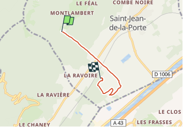
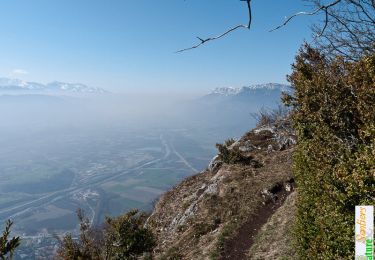
Ruta Parapente de 3,6 km a descubrir en Auvergne-Rhône-Alpes, Saboya, Saint-Jean-de-la-Porte. Esta ruta ha sido propuesta por loicthev.
Descripción
vol montlambert stage initiation
3eme Vol
deco Montlambert
10/05/2024
Alexandre
Localización
País:
France
Región :
Auvergne-Rhône-Alpes
Departamento/provincia :
Saboya
Municipio :
Saint-Jean-de-la-Porte
Localidad:
Unknown
Salida:(Dec)
Salida:(UTM)
273993 ; 5048429 (32T) N.
Comentarios
Excursiones cerca
![Excursión Senderismo Arbin - La Roche du Guet depuis Arbin, Montmélian - Photo](https://media.geolcdn.com/t/375/260/ext.jpg?maxdim=2&url=https%3A%2F%2Fservices.sitytrail.com%2FGeolivesWS%2FDownloadMedia.ashx%3FTrailID%3D106315%26Media%3D10750_1.jpg)
![Senderismo Senderismo](https://static1.geolcdn.com/sitytour/trail-icons/101.png)
La Roche du Guet depuis Arbin, Montmélian
Senderismo
Medio
(1)
Arbin,
Auvergne-Rhône-Alpes,
Saboya,
France
![](/images/other/stat-length.png)
9,5 km | 21 km-effort
6h 0min
![](https://static1.geolcdn.com/siteimages/upload/files/16400158638029165_repeat_loop_refresh_sync_direction_icon.png)
Sí
![Excursión Senderismo Saint-Pierre-d'Albigny - La Dent d'Arclusaz, 2041m - Photo](https://media.geolcdn.com/t/375/260/ext.jpg?maxdim=2&url=https%3A%2F%2Fservices.sitytrail.com%2FGeolivesWS%2FDownloadMedia.ashx%3FTrailID%3D105785%26Media%3D9678_1.jpg)
![Senderismo Senderismo](https://static1.geolcdn.com/sitytour/trail-icons/101.png)
La Dent d'Arclusaz, 2041m
Senderismo
Difícil
(2)
Saint-Pierre-d'Albigny,
Auvergne-Rhône-Alpes,
Saboya,
France
![](/images/other/stat-length.png)
13,9 km | 29 km-effort
7h 30min
![](https://static1.geolcdn.com/siteimages/upload/files/16400158638029165_repeat_loop_refresh_sync_direction_icon.png)
Sí
![Excursión Senderismo Aillon-le-Jeune - La Pointe de la Galoppaz 1680m, depuis le Col du Lindar - Photo](https://media.geolcdn.com/t/375/260/ext.jpg?maxdim=2&url=https%3A%2F%2Fservices.sitytrail.com%2FGeolivesWS%2FDownloadMedia.ashx%3FTrailID%3D103728%26Media%3D6391_1.jpg)
![Senderismo Senderismo](https://static1.geolcdn.com/sitytour/trail-icons/101.png)
La Pointe de la Galoppaz 1680m, depuis le Col du Lindar
Senderismo
Fácil
(1)
Aillon-le-Jeune,
Auvergne-Rhône-Alpes,
Saboya,
France
![](/images/other/stat-length.png)
7,4 km | 14,9 km-effort
3h 45min
![](https://static1.geolcdn.com/siteimages/upload/files/16400158638029165_repeat_loop_refresh_sync_direction_icon.png)
No
![Excursión Bici de montaña La Thuile - Bauges - La vallée du Lindar - Photo](https://media.geolcdn.com/t/375/260/ext.jpg?maxdim=2&url=https%3A%2F%2Fservices.sitytrail.com%2FGeolivesWS%2FDownloadMedia.ashx%3FTrailID%3D102183%26Media%3D2575_1.jpg)
![Bici de montaña Bici de montaña](https://static1.geolcdn.com/sitytour/trail-icons/202.png)
Bauges - La vallée du Lindar
Bici de montaña
Difícil
(1)
La Thuile,
Auvergne-Rhône-Alpes,
Saboya,
France
![](/images/other/stat-length.png)
18 km | 31 km-effort
3h 0min
![](https://static1.geolcdn.com/siteimages/upload/files/16400158638029165_repeat_loop_refresh_sync_direction_icon.png)
Sí
![Excursión Senderismo La Thuile - roche de Guet et Roc d Tormery - Photo](https://media.geolcdn.com/t/375/260/e3e63a57-8149-490c-b05a-84cb7ccee5b7.jpg&format=jpg&maxdim=2)
![Senderismo Senderismo](https://static1.geolcdn.com/sitytour/trail-icons/101.png)
roche de Guet et Roc d Tormery
Senderismo
Fácil
La Thuile,
Auvergne-Rhône-Alpes,
Saboya,
France
![](/images/other/stat-length.png)
10,1 km | 17,6 km-effort
2h 48min
![](https://static1.geolcdn.com/siteimages/upload/files/16400158638029165_repeat_loop_refresh_sync_direction_icon.png)
Sí
![Excursión Raquetas de nieve Thoiry - Bauges Pointe de la Galoppaz - Photo](https://media.geolcdn.com/t/375/260/ext.jpg?maxdim=2&url=https%3A%2F%2Fstatic1.geolcdn.com%2Fsiteimages%2Fupload%2Ffiles%2F1524743153raquette.jpg)
![Raquetas de nieve Raquetas de nieve](https://static1.geolcdn.com/sitytour/trail-icons/504.png)
Bauges Pointe de la Galoppaz
Raquetas de nieve
Medio
(1)
Thoiry,
Auvergne-Rhône-Alpes,
Saboya,
France
![](/images/other/stat-length.png)
9,7 km | 18,7 km-effort
4h 22min
![](https://static1.geolcdn.com/siteimages/upload/files/16400158638029165_repeat_loop_refresh_sync_direction_icon.png)
Sí
![Excursión Senderismo La Thuile - Balade au lac de là Thuile - Photo](https://media.geolcdn.com/t/375/260/2c9dd213-d252-46e3-bfea-8a8c0abc45db.jpg&format=jpg&maxdim=2)
![Senderismo Senderismo](https://static1.geolcdn.com/sitytour/trail-icons/101.png)
Balade au lac de là Thuile
Senderismo
Fácil
La Thuile,
Auvergne-Rhône-Alpes,
Saboya,
France
![](/images/other/stat-length.png)
9,7 km | 13,9 km-effort
3h 39min
![](https://static1.geolcdn.com/siteimages/upload/files/16400158638029165_repeat_loop_refresh_sync_direction_icon.png)
Sí
![Excursión Senderismo Sainte-Reine - Mont Pelat - Photo](https://media.geolcdn.com/t/375/260/7f0ecbf2-604f-4efc-a503-ee88b8b0b343.jpg&format=jpg&maxdim=2)
![Senderismo Senderismo](https://static1.geolcdn.com/sitytour/trail-icons/101.png)
Mont Pelat
Senderismo
Medio
Sainte-Reine,
Auvergne-Rhône-Alpes,
Saboya,
France
![](/images/other/stat-length.png)
15,5 km | 28 km-effort
4h 51min
![](https://static1.geolcdn.com/siteimages/upload/files/16400158638029165_repeat_loop_refresh_sync_direction_icon.png)
Sí
![Excursión Senderismo Sainte-Reine - Routhennes - col du potat - Photo](https://media.geolcdn.com/t/375/260/65fed8de-b503-4ecb-aa1d-a1896419183d.jpg&format=jpg&maxdim=2)
![Senderismo Senderismo](https://static1.geolcdn.com/sitytour/trail-icons/101.png)
Routhennes - col du potat
Senderismo
Medio
Sainte-Reine,
Auvergne-Rhône-Alpes,
Saboya,
France
![](/images/other/stat-length.png)
8,9 km | 16,6 km-effort
3h 42min
![](https://static1.geolcdn.com/siteimages/upload/files/16400158638029165_repeat_loop_refresh_sync_direction_icon.png)
Sí