


5,8 km | 11,5 km-effort


Usuario


Aplicación GPS de excursión GRATIS
 SityTrail
IGN / Institutos geográficos
SityTrail World
El mundo es suyo
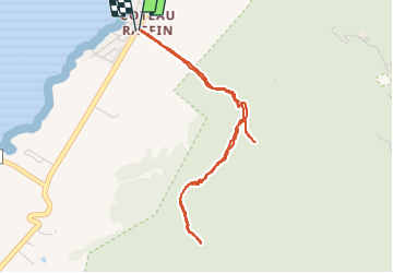
Ruta Otra actividad de 6,2 km a descubrir en Black River. Esta ruta ha sido propuesta por njourdain.
The track starts off at a bus stop in the village of La Gaulette. Here, a dirt road diverges from the main road (Coastal Road) towards the mountain. Consult the GPS log not to miss the right dirt road as it seems the only one not on private property.
Follow the dirt road for about 500m to a t-junction and head straight forward on a clearly visible, steep footpath which will bring you onto the saddle between Piton Canot and Mt Laporte. On the saddle, you will see a house with a red roof on your right. Pass this house on the right-hand side along the fence sourounding the property. The fence continues almost all the way up to the summit of Mt Laporte. On the private side there is a well maintained footpath. Unfortunately, on the public side of the fence there is no path at all and a lot of bush bashing is necessary to make your way up. Long pants and gloves are highly recommended. Also proceed with care as the fence is very close to the cliffs in places. Make your way best you can until you face a bare rock of some 3 meters. This might seem daunting since the rock is very close to the cliff but it can easily be climed holding onto the fence and roots - but be careful as some of the roots as well as some fence poles are rotten and not reliable to hold onto! Continue along the fence through the bushes until another bare rock just before the final ascent to Mt Laporte. This one can easily be climbed keeping close to the fence, which will after this point bear to the left and down again. From here there is a proper footpath on the ridge easy to follow to the summit and further on to Piton du Fouge. But watch your step as there are several iron rods in the ground which are easy to stumble across.
The footpath actually continues on the ridge from Piton du Fouge probably leading to two smaller peaks in the south and possibly even further towards Baie du Cap. This however is subject to confirmation.
If you are up for this hike it may be well worth to ask permission to use the private path. This will undoubtedly make the hike easier and more enjoyable.
