![](/images/other/stat-length.png)
![Excursión Senderismo Ξυλοκερατίδι - Xylokeratídi - Ta Nerá - Víglia - Xylokeratídi - Photo](https://media.geolcdn.com/t/1900/400/ext.pjpeg?maxdim=2&url=https%3A%2F%2Fstatic1.geolcdn.com%2Fsiteimages%2Fupload%2Ffiles%2F1553511878bg_sport_marche.png)
Xylokeratídi - Ta Nerá - Víglia - Xylokeratídi
herve.feurprier
Usuario
![Longitud](/images/other/stat-length.png)
Longitud
4,5 km
![Altitud máxima](https://static1.geolcdn.com/siteimages/upload/files/1508320355ic_sort_altitude_max_24dp.png)
Altitud máxima
129 m
![Desnivel positivo](https://static1.geolcdn.com/siteimages/upload/files/1508320355ic_sort_den_pos_24dp.png)
Desnivel positivo
136 m
![Km-Effort](/images/other/stat-length.png)
Km-Effort
6,4 km
![Altitud mínima](https://static1.geolcdn.com/siteimages/upload/files/1508320355ic_sort_altitude_min_24dp.png)
Altitud mínima
0 m
![Desnivel negativo](https://static1.geolcdn.com/siteimages/upload/files/1508320355ic_sort_den_neg_24dp.png)
Desnivel negativo
141 m
![Boucle](https://static1.geolcdn.com/siteimages/upload/files/16400158638029165_repeat_loop_refresh_sync_direction_icon.png)
Boucle
No
Fecha de creación :
2019-05-18 00:54:02.949
Última modificación :
2019-05-18 00:54:05.851
![Senderismo](https://static1.geolcdn.com/sitytour/trail-icons/101.png)
1h23
Dificultad : Desconocido
![Escanee este código QR para abrir la excursión en la aplicación SityTrail](https://capi.geolives.com/qq0zvz2zws4bq2lad0pu/sitytour/trails/402933/qr.png?size=200)
Aplicación GPS de excursión GRATIS
A propósito
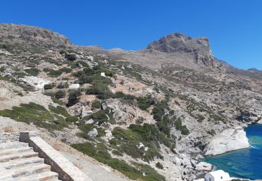
Ruta Senderismo de 4,5 km a descubrir en Αποκεντρωμένη Διοίκηση Αιγαίου, Περιφερειακή Ενότητα Νάξου. Esta ruta ha sido propuesta por herve.feurprier.
Descripción
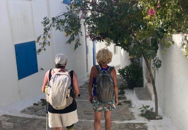
Manque le tout début car le départ se fait au même endroit que l'arrivée (villa le grand bleu )
Localización
País:
Greece
Región :
Αποκεντρωμένη Διοίκηση Αιγαίου
Departamento/provincia :
Περιφερειακή Ενότητα Νάξου
Municipio :
Ξυλοκερατίδι
Localidad:
Unknown
Salida:(Dec)
Salida:(UTM)
398635 ; 4076758 (35S) N.
Comentarios
Excursiones cerca
![Excursión Senderismo - Chora>>monastère >> chora>>katapola - Photo](https://media.geolcdn.com/t/375/260/e5bb279e-9a59-491f-b4af-37ced39e52ef.jpg&format=jpg&maxdim=2)
![Senderismo Senderismo](https://static1.geolcdn.com/sitytour/trail-icons/101.png)
Chora>>monastère >> chora>>katapola
Senderismo
Muy difícil
,
Αποκεντρωμένη Διοίκηση Αιγαίου,
Περιφερειακή Ενότητα Νάξου,
Greece
![](/images/other/stat-length.png)
15,7 km | 24 km-effort
4h 51min
![](https://static1.geolcdn.com/siteimages/upload/files/16400158638029165_repeat_loop_refresh_sync_direction_icon.png)
No
![Excursión Senderismo - chora à katapola - Photo](https://media.geolcdn.com/t/375/260/9b736b99-e0d1-42d3-88c8-249c261aa090.jpg&format=jpg&maxdim=2)
![Senderismo Senderismo](https://static1.geolcdn.com/sitytour/trail-icons/101.png)
chora à katapola
Senderismo
Medio
(1)
,
Αποκεντρωμένη Διοίκηση Αιγαίου,
Περιφερειακή Ενότητα Νάξου,
Greece
![](/images/other/stat-length.png)
3,8 km | 4,8 km-effort
1h 14min
![](https://static1.geolcdn.com/siteimages/upload/files/16400158638029165_repeat_loop_refresh_sync_direction_icon.png)
No
![Excursión Senderismo - Monastère Chozoviotissa - Photo](https://media.geolcdn.com/t/375/260/dc16df41-f50c-4a57-8fbb-6f25233cef55.jpg&format=jpg&maxdim=2)
![Senderismo Senderismo](https://static1.geolcdn.com/sitytour/trail-icons/101.png)
Monastère Chozoviotissa
Senderismo
,
Αποκεντρωμένη Διοίκηση Αιγαίου,
Περιφερειακή Ενότητα Νάξου,
Greece
![](/images/other/stat-length.png)
12,3 km | 22 km-effort
4h 6min
![](https://static1.geolcdn.com/siteimages/upload/files/16400158638029165_repeat_loop_refresh_sync_direction_icon.png)
Sí
![Excursión sport - Amorgos 24 monastère - Photo](https://media.geolcdn.com/t/375/260/a16e9356-b52d-46aa-8225-23703bb67210.jpg&format=jpg&maxdim=2)
Amorgos 24 monastère
sport
Muy fácil
,
Αποκεντρωμένη Διοίκηση Αιγαίου,
Περιφερειακή Ενότητα Νάξου,
Greece
![](/images/other/stat-length.png)
17,1 km | 28 km-effort
Desconocido
![](https://static1.geolcdn.com/siteimages/upload/files/16400158638029165_repeat_loop_refresh_sync_direction_icon.png)
No
![Excursión Senderismo - Katapola>> barrage >>plage >>Minoa>>Katapola - Photo](https://media.geolcdn.com/t/375/260/3212fcb7-1d0b-4066-9805-37ddb7f32750.jpg&format=jpg&maxdim=2)
![Senderismo Senderismo](https://static1.geolcdn.com/sitytour/trail-icons/101.png)
Katapola>> barrage >>plage >>Minoa>>Katapola
Senderismo
Muy difícil
,
Αποκεντρωμένη Διοίκηση Αιγαίου,
Περιφερειακή Ενότητα Νάξου,
Greece
![](/images/other/stat-length.png)
13,8 km | 21 km-effort
4h 23min
![](https://static1.geolcdn.com/siteimages/upload/files/16400158638029165_repeat_loop_refresh_sync_direction_icon.png)
No
![Excursión Senderismo - Katapola>>chora - Photo](https://media.geolcdn.com/t/375/260/8d910ca7-9f79-4605-add1-aa0c32baae28.jpg&format=jpg&maxdim=2)
![Senderismo Senderismo](https://static1.geolcdn.com/sitytour/trail-icons/101.png)
Katapola>>chora
Senderismo
Medio
,
Αποκεντρωμένη Διοίκηση Αιγαίου,
Περιφερειακή Ενότητα Νάξου,
Greece
![](/images/other/stat-length.png)
4,2 km | 7,5 km-effort
1h 25min
![](https://static1.geolcdn.com/siteimages/upload/files/16400158638029165_repeat_loop_refresh_sync_direction_icon.png)
No
![Excursión Senderismo - monastère et plage asiatique anna - Photo](https://media.geolcdn.com/t/375/260/07e769a5-9cc2-4343-bbef-6de59e759fe4.jpg&format=jpg&maxdim=2)
![Senderismo Senderismo](https://static1.geolcdn.com/sitytour/trail-icons/101.png)
monastère et plage asiatique anna
Senderismo
Medio
,
Αποκεντρωμένη Διοίκηση Αιγαίου,
Περιφερειακή Ενότητα Νάξου,
Greece
![](/images/other/stat-length.png)
7,4 km | 14,1 km-effort
4h 11min
![](https://static1.geolcdn.com/siteimages/upload/files/16400158638029165_repeat_loop_refresh_sync_direction_icon.png)
No
![Excursión Senderismo - Amorgos - Ruines de Minos et plage - Photo](https://media.geolcdn.com/t/375/260/48ea6731-8ae3-4637-b196-fd03fcd3d73d.jpg&format=jpg&maxdim=2)
![Senderismo Senderismo](https://static1.geolcdn.com/sitytour/trail-icons/101.png)
Amorgos - Ruines de Minos et plage
Senderismo
Fácil
,
Αποκεντρωμένη Διοίκηση Αιγαίου,
Περιφερειακή Ενότητα Νάξου,
Greece
![](/images/other/stat-length.png)
10,4 km | 15,8 km-effort
3h 14min
![](https://static1.geolcdn.com/siteimages/upload/files/16400158638029165_repeat_loop_refresh_sync_direction_icon.png)
Sí
![Excursión Senderismo - 2022-05-23_12h12m37_0906_6setrdzp8_Walking-Path-7-Evangeistria-Amorgos - Photo](https://media.geolcdn.com/t/375/260/ext.jpg?maxdim=2&url=https%3A%2F%2Fstatic1.geolcdn.com%2Fsiteimages%2Fupload%2Ffiles%2F1553511878bg_sport_marche.png)
![Senderismo Senderismo](https://static1.geolcdn.com/sitytour/trail-icons/101.png)
2022-05-23_12h12m37_0906_6setrdzp8_Walking-Path-7-Evangeistria-Amorgos
Senderismo
Fácil
,
Αποκεντρωμένη Διοίκηση Αιγαίου,
Περιφερειακή Ενότητα Νάξου,
Greece
![](/images/other/stat-length.png)
3,7 km | 5,5 km-effort
1h 14min
![](https://static1.geolcdn.com/siteimages/upload/files/16400158638029165_repeat_loop_refresh_sync_direction_icon.png)
Sí