![](/images/other/stat-length.png)
![Excursión Senderismo Aulan - 26 Aulan Poët en Percip - Photo](https://media.geolcdn.com/t/1900/400/46c7bb6d-0b90-4bb1-97bc-ec1d2b520019.jpg&format=pjpeg&maxdim=2)
26 Aulan Poët en Percip
Maryma
Usuario
![Longitud](/images/other/stat-length.png)
![Altitud máxima](https://static1.geolcdn.com/siteimages/upload/files/1508320355ic_sort_altitude_max_24dp.png)
![Desnivel positivo](https://static1.geolcdn.com/siteimages/upload/files/1508320355ic_sort_den_pos_24dp.png)
![Km-Effort](/images/other/stat-length.png)
![Altitud mínima](https://static1.geolcdn.com/siteimages/upload/files/1508320355ic_sort_altitude_min_24dp.png)
![Desnivel negativo](https://static1.geolcdn.com/siteimages/upload/files/1508320355ic_sort_den_neg_24dp.png)
![Boucle](https://static1.geolcdn.com/siteimages/upload/files/16400158638029165_repeat_loop_refresh_sync_direction_icon.png)
![Senderismo](https://static1.geolcdn.com/sitytour/trail-icons/101.png)
5h00
Dificultad : Medio
![Escanee este código QR para abrir la excursión en la aplicación SityTrail](https://capi.geolives.com/qq0zvz2zws4bq2lad0pu/sitytour/trails/4027930/qr.png?size=200)
Aplicación GPS de excursión GRATIS
A propósito
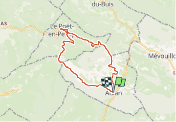
Ruta Senderismo de 15,2 km a descubrir en Auvergne-Rhône-Alpes, Drôme, Aulan. Esta ruta ha sido propuesta por Maryma.
Descripción
C'est sur la commune d'Aulan que le Toulourenc prend sa source. Le village, établi sur un promontoire, domine la jonction du Toulourenc et du torrent du Quinsans. Il est occupé depuis la préhistoire et c'est au Moyen Age que s'y établi un château primitif.
Fin 19è - début 20è, s'effectue un reboisement en pins noirs d'Autriche pour pallier au surpâturage. Au milieu du 19è siècle se développe la culture de la lavande. Actuellement la commune compte 11 habitants vivant de la culture de la lavande et de l'élevage d'ovins et de caprins.
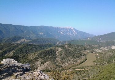
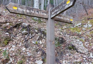
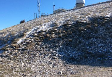
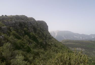
Le chemin débute en sous-bois, dans les pins. A partir du col de la Bohémienne, un paysage marneux fait place. D'impressionnants ravins s'offrent à notre vue. Attention à ne pas faire de faux pas ;-)
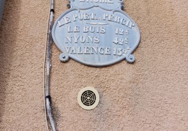
Arrivée au Poët sous un arceau de grands buis que la pyrale, pour notre plus grand éblouissement, à oublier de dévorer!
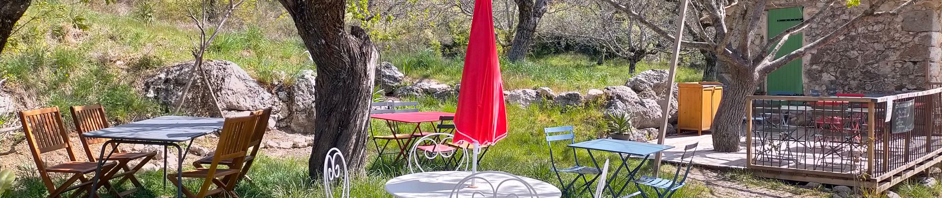
Ne pas hésiter à faire le tour de ce joli village. Une halte boisson est même proposée aux beaux jours! On peut pique-niquer au pied de la croix à la sortie du village.
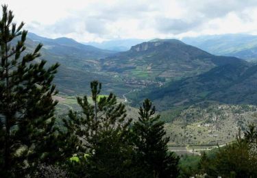
Le chemin alors s'ouvre sur de vastes paysages, avec au premier plan, des champs de lavande. En descendant vers Aulan, des troupeaux. Et des chiens de garde...
On retrouve le terrain marneux juste avant de rejoindre le château, dont on peut faire le tour (gîte, chapelle...) Des visites sont possibles dès le mois d'avril. Se renseigner.
Localización
Comentarios
Excursiones cerca
![Excursión Senderismo Montbrun-les-Bains - montbrun buc - Photo](https://media.geolcdn.com/t/375/260/ext.jpg?maxdim=2&url=https%3A%2F%2Fservices.sitytrail.com%2FGeolivesWS%2FDownloadMedia.ashx%3FTrailID%3D345092%26Media%3Dfix__20140914093015.jpg)
![Senderismo Senderismo](https://static1.geolcdn.com/sitytour/trail-icons/101.png)
Senderismo
![](/images/other/stat-length.png)
![](https://static1.geolcdn.com/siteimages/upload/files/16400158638029165_repeat_loop_refresh_sync_direction_icon.png)
![Excursión Senderismo Le Poët-en-Percip - Le Poèt du Bout du Monde - Photo](https://media.geolcdn.com/t/375/260/1569e818-5455-4f23-8c9a-380b223c1c41.jpg&format=jpg&maxdim=2)
![Senderismo Senderismo](https://static1.geolcdn.com/sitytour/trail-icons/101.png)
Senderismo
![](/images/other/stat-length.png)
![](https://static1.geolcdn.com/siteimages/upload/files/16400158638029165_repeat_loop_refresh_sync_direction_icon.png)
![Excursión Senderismo Savoillan - Cabane de Pié Gù - Photo](https://media.geolcdn.com/t/375/260/e5f5a4aa-7bb0-4bc8-ae8e-807630a724b1.jpg&format=jpg&maxdim=2)
![Senderismo Senderismo](https://static1.geolcdn.com/sitytour/trail-icons/101.png)
Senderismo
![](/images/other/stat-length.png)
![](https://static1.geolcdn.com/siteimages/upload/files/16400158638029165_repeat_loop_refresh_sync_direction_icon.png)
![Excursión Bici de montaña Reilhanette - La Grande Traversée VTT de Vaucluse via Le Luberon - Photo](https://media.geolcdn.com/t/375/260/ext.jpg?maxdim=2&url=https%3A%2F%2Fservices.sitytrail.com%2FGeolivesWS%2FDownloadMedia.ashx%3FTrailID%3D492091%26Media%3Dcb7d4863-e894-44a8-b739-43160282a3da.jpg)
![Bici de montaña Bici de montaña](https://static1.geolcdn.com/sitytour/trail-icons/202.png)
Bici de montaña
![](/images/other/stat-length.png)
![](https://static1.geolcdn.com/siteimages/upload/files/16400158638029165_repeat_loop_refresh_sync_direction_icon.png)
![Excursión Bici de montaña Savoillan - La Grande Traversée VTT de Vaucluse via les Monts de Vaucluse - Photo](https://media.geolcdn.com/t/375/260/ext.jpg?maxdim=2&url=https%3A%2F%2Fservices.sitytrail.com%2FGeolivesWS%2FDownloadMedia.ashx%3FTrailID%3D394933%26Media%3D267b84bb-3e86-420e-a33d-46d0ab1ea19e.jpg)
![Bici de montaña Bici de montaña](https://static1.geolcdn.com/sitytour/trail-icons/202.png)
Bici de montaña
![](/images/other/stat-length.png)
![](https://static1.geolcdn.com/siteimages/upload/files/16400158638029165_repeat_loop_refresh_sync_direction_icon.png)
![Excursión Senderismo Savoillan - Sentier Land Art - Photo](https://media.geolcdn.com/t/375/260/bfb73420-cb1c-436c-a9d5-8f130ed88a0c.jpg&format=jpg&maxdim=2)
![Senderismo Senderismo](https://static1.geolcdn.com/sitytour/trail-icons/101.png)
Senderismo
![](/images/other/stat-length.png)
![](https://static1.geolcdn.com/siteimages/upload/files/16400158638029165_repeat_loop_refresh_sync_direction_icon.png)
![Bici de montaña Bici de montaña](https://static1.geolcdn.com/sitytour/trail-icons/202.png)
Bici de montaña
![](/images/other/stat-length.png)
![](https://static1.geolcdn.com/siteimages/upload/files/16400158638029165_repeat_loop_refresh_sync_direction_icon.png)
![Excursión Senderismo Le Poët-en-Percip - Le Poët en Percip - Aulan - Montagne de la Bohémienne - Photo](https://media.geolcdn.com/t/375/260/ext.jpg?maxdim=2&url=https%3A%2F%2Fservices.sitytrail.com%2FGeolivesWS%2FDownloadMedia.ashx%3FTrailID%3D105312%26Media%3D9003_3.jpg)
![Senderismo Senderismo](https://static1.geolcdn.com/sitytour/trail-icons/101.png)
Senderismo
![](/images/other/stat-length.png)
![](https://static1.geolcdn.com/siteimages/upload/files/16400158638029165_repeat_loop_refresh_sync_direction_icon.png)
![Excursión Senderismo Le Poët-en-Percip - montagne de Banne - Photo](https://media.geolcdn.com/t/375/260/df287183-f394-4400-ab94-4b4c9f2a8c15.jpg&format=jpg&maxdim=2)
![Senderismo Senderismo](https://static1.geolcdn.com/sitytour/trail-icons/101.png)
Senderismo
![](/images/other/stat-length.png)
![](https://static1.geolcdn.com/siteimages/upload/files/16400158638029165_repeat_loop_refresh_sync_direction_icon.png)