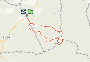
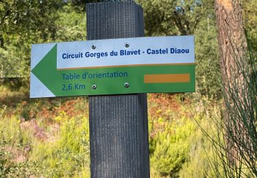
![](/images/other/stat-length.png)
![Excursión Senderismo Tourrettes - Chêne chevelu et chêne crénelé - Photo](https://media.geolcdn.com/t/1900/400/0647bcb0-53a2-4ab7-a8b3-01ff38e59da6.jpg&format=pjpeg&maxdim=2)
Chêne chevelu et chêne crénelé
boulinevelyne
Usuario
![Longitud](/images/other/stat-length.png)
![Altitud máxima](https://static1.geolcdn.com/siteimages/upload/files/1508320355ic_sort_altitude_max_24dp.png)
![Desnivel positivo](https://static1.geolcdn.com/siteimages/upload/files/1508320355ic_sort_den_pos_24dp.png)
![Km-Effort](/images/other/stat-length.png)
![Altitud mínima](https://static1.geolcdn.com/siteimages/upload/files/1508320355ic_sort_altitude_min_24dp.png)
![Desnivel negativo](https://static1.geolcdn.com/siteimages/upload/files/1508320355ic_sort_den_neg_24dp.png)
![Boucle](https://static1.geolcdn.com/siteimages/upload/files/16400158638029165_repeat_loop_refresh_sync_direction_icon.png)
![Senderismo](https://static1.geolcdn.com/sitytour/trail-icons/101.png)
2h13
Dificultad : Medio
![Escanee este código QR para abrir la excursión en la aplicación SityTrail](https://capi.geolives.com/qq0zvz2zws4bq2lad0pu/sitytour/trails/4023196/qr.png?size=200)
Aplicación GPS de excursión GRATIS
A propósito
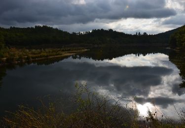
Ruta Senderismo de 7 km a descubrir en Provenza-Alpes-Costa Azul, Var, Tourrettes. Esta ruta ha sido propuesta por boulinevelyne.
Descripción
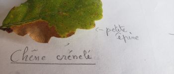
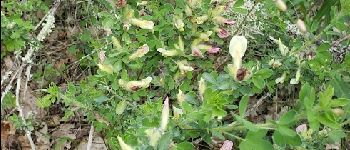
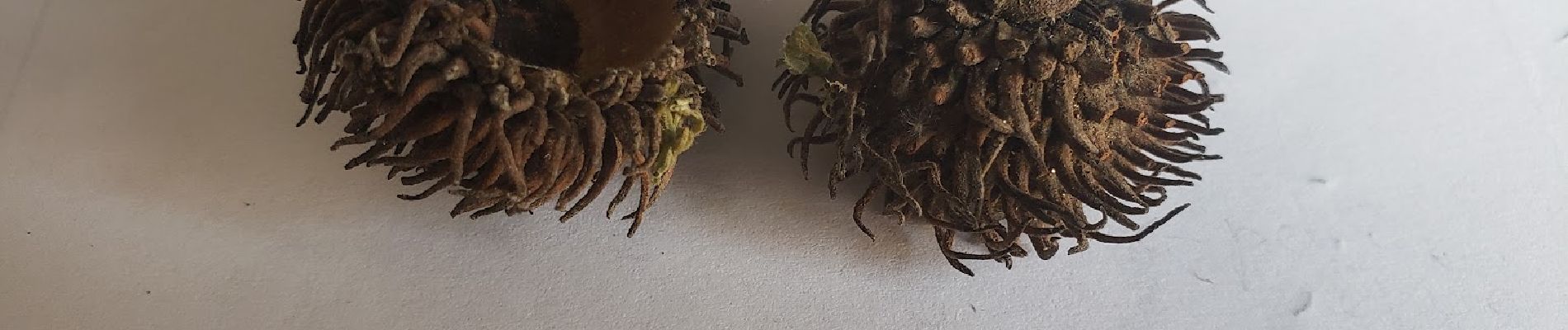
-Le chêne crénelé (Quercus crénata) à un tronc avec un peu de liège.
Feuille légèrement lobée avec présence d'une petite épine au sommet du lobe. Feuille
C'est un hybride entre le chêne chevelu et le chêne liège.
-Le chêne chevelu(Quercus cerris) a des feuilles plus lobées et surtout un tronc présentant des sillons parallèles et trace jaune orange au fond du sillon. Cupule du gland chevelu.
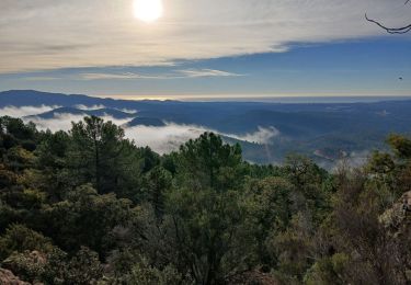
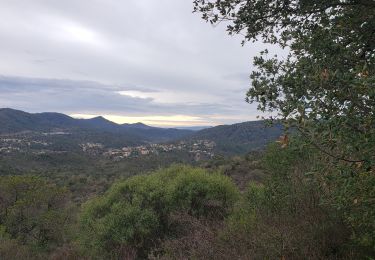
Un peu de Géologie:
Nous sommes sur des gneiss, c.a.d une roche métamorphique brassée en profondeur, compressée ce qui donne à la roche cet aspect de stratification foliacée très fine.
du Sud au Nord on a :
une roche volcanique l'esterel puis le carbonifère avec la vallée du Reyran ,le gneiss où nous randonnons et enfin la provence calcaire au Nord.
Localización
Comentarios
Excursiones cerca
![Excursión Senderismo Montauroux - CP FONDURANE - Photo](https://media.geolcdn.com/t/375/260/ext.jpg?maxdim=2&url=https%3A%2F%2Fstatic1.geolcdn.com%2Fsiteimages%2Fupload%2Ffiles%2F1553511878bg_sport_marche.png)
![Senderismo Senderismo](https://static1.geolcdn.com/sitytour/trail-icons/101.png)
Senderismo
![](/images/other/stat-length.png)
![](https://static1.geolcdn.com/siteimages/upload/files/16400158638029165_repeat_loop_refresh_sync_direction_icon.png)
![Excursión A pie Bagnols-en-Forêt - BAGNOLS EN FORET- Bois du défens DRI - Photo](https://media.geolcdn.com/t/375/260/ext.jpg?maxdim=2&url=https%3A%2F%2Fstatic1.geolcdn.com%2Fsiteimages%2Fupload%2Ffiles%2F1545311037marcheuse_200dpi.jpg)
![A pie A pie](https://static1.geolcdn.com/sitytour/trail-icons/100.png)
A pie
![](/images/other/stat-length.png)
![](https://static1.geolcdn.com/siteimages/upload/files/16400158638029165_repeat_loop_refresh_sync_direction_icon.png)
![Excursión Senderismo Montauroux - Frankrijk - Lac de St. Cassien - Provence - Photo](https://media.geolcdn.com/t/375/260/ext.jpg?maxdim=2&url=https%3A%2F%2Fstatic1.geolcdn.com%2Fsiteimages%2Fupload%2Ffiles%2F1553511878bg_sport_marche.png)
![Senderismo Senderismo](https://static1.geolcdn.com/sitytour/trail-icons/101.png)
Senderismo
![](/images/other/stat-length.png)
![](https://static1.geolcdn.com/siteimages/upload/files/16400158638029165_repeat_loop_refresh_sync_direction_icon.png)
![Excursión sport Bagnols-en-Forêt - Lac Rioutard Bagnols en forêt - Photo](https://media.geolcdn.com/t/375/260/0154e3c4-4912-418f-af0f-e920b58b6bc0.jpg&format=jpg&maxdim=2)
sport
![](/images/other/stat-length.png)
![](https://static1.geolcdn.com/siteimages/upload/files/16400158638029165_repeat_loop_refresh_sync_direction_icon.png)
![Excursión Senderismo Bagnols-en-Forêt - Bagnols en Forêt, Pic de la Gardiette , Oppidum de La Forteresse - Photo](https://media.geolcdn.com/t/375/260/667ab0dc-5c64-4e1e-a401-74d35bc7da93.jpg&format=jpg&maxdim=2)
![Senderismo Senderismo](https://static1.geolcdn.com/sitytour/trail-icons/101.png)
Senderismo
![](/images/other/stat-length.png)
![](https://static1.geolcdn.com/siteimages/upload/files/16400158638029165_repeat_loop_refresh_sync_direction_icon.png)
![Excursión Senderismo Montauroux - Le lac de Saint Cassien et la réserve biologique de Fondurane - Photo](https://media.geolcdn.com/t/375/260/624cf528-9da6-482e-b332-cea4bc123d23.jpg&format=jpg&maxdim=2)
![Senderismo Senderismo](https://static1.geolcdn.com/sitytour/trail-icons/101.png)
Senderismo
![](/images/other/stat-length.png)
![](https://static1.geolcdn.com/siteimages/upload/files/16400158638029165_repeat_loop_refresh_sync_direction_icon.png)
![Senderismo Senderismo](https://static1.geolcdn.com/sitytour/trail-icons/101.png)
Senderismo
![](/images/other/stat-length.png)
![](https://static1.geolcdn.com/siteimages/upload/files/16400158638029165_repeat_loop_refresh_sync_direction_icon.png)
![Excursión Senderismo Bagnols-en-Forêt - Crête Diaou et gorges du Blavet - Photo](https://media.geolcdn.com/t/375/260/0563a74e-6187-4a3f-95b0-3365c5ea2cf0.jpg&format=jpg&maxdim=2)
![Senderismo Senderismo](https://static1.geolcdn.com/sitytour/trail-icons/101.png)
Senderismo
![](/images/other/stat-length.png)
![](https://static1.geolcdn.com/siteimages/upload/files/16400158638029165_repeat_loop_refresh_sync_direction_icon.png)
![Excursión Senderismo Bagnols-en-Forêt - 20210310 Bayonne Blavet Forteresse 3 - Photo](https://media.geolcdn.com/t/375/260/f6c74315-02b1-4d30-95c6-7b8bcd2db7ef.jpg&format=jpg&maxdim=2)
![Senderismo Senderismo](https://static1.geolcdn.com/sitytour/trail-icons/101.png)
Senderismo
![](/images/other/stat-length.png)
![](https://static1.geolcdn.com/siteimages/upload/files/16400158638029165_repeat_loop_refresh_sync_direction_icon.png)