![](/images/other/stat-length.png)
![Excursión Senderismo Gilette - Bouyon depuis Gilette (06) - Photo](https://media.geolcdn.com/t/1900/400/ext.pjpeg?maxdim=2&url=https%3A%2F%2Fstatic1.geolcdn.com%2Fsiteimages%2Fupload%2Ffiles%2F1553511878bg_sport_marche.png)
Bouyon depuis Gilette (06)
GeorgesV.
Usuario
![Longitud](/images/other/stat-length.png)
Longitud
19,3 km
![Altitud máxima](https://static1.geolcdn.com/siteimages/upload/files/1508320355ic_sort_altitude_max_24dp.png)
Altitud máxima
650 m
![Desnivel positivo](https://static1.geolcdn.com/siteimages/upload/files/1508320355ic_sort_den_pos_24dp.png)
Desnivel positivo
971 m
![Km-Effort](/images/other/stat-length.png)
Km-Effort
32 km
![Altitud mínima](https://static1.geolcdn.com/siteimages/upload/files/1508320355ic_sort_altitude_min_24dp.png)
Altitud mínima
143 m
![Desnivel negativo](https://static1.geolcdn.com/siteimages/upload/files/1508320355ic_sort_den_neg_24dp.png)
Desnivel negativo
961 m
![Boucle](https://static1.geolcdn.com/siteimages/upload/files/16400158638029165_repeat_loop_refresh_sync_direction_icon.png)
Boucle
Sí
Fecha de creación :
2024-04-14 06:18:58.0
Última modificación :
2024-04-15 16:12:10.552
![Senderismo](https://static1.geolcdn.com/sitytour/trail-icons/101.png)
7h19
Dificultad : Muy difícil
![Escanee este código QR para abrir la excursión en la aplicación SityTrail](https://capi.geolives.com/qq0zvz2zws4bq2lad0pu/sitytour/trails/4016381/qr.png?size=200)
Aplicación GPS de excursión GRATIS
A propósito
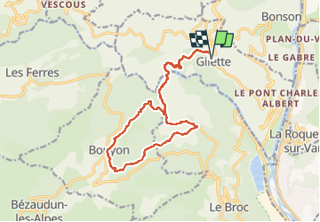
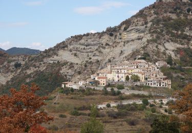
Ruta Senderismo de 19,3 km a descubrir en Provenza-Alpes-Costa Azul, Alpes Marítimos, Gilette. Esta ruta ha sido propuesta por GeorgesV..
Descripción
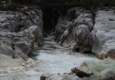
Randonnée difficile de 20 km et 1000 m de dénivelé. Les paysages sont superbes et les sentiers très variés.
Localización
País:
France
Región :
Provenza-Alpes-Costa Azul
Departamento/provincia :
Alpes Marítimos
Municipio :
Gilette
Localidad:
Unknown
Salida:(Dec)
Salida:(UTM)
352353 ; 4856931 (32T) N.
Comentarios
Excursiones cerca
![Excursión A pie Bouyon - track - Photo](https://media.geolcdn.com/t/375/260/69f80d39-c5dd-4687-bdd8-c0bd3948bfa4.jpg&format=jpg&maxdim=2)
![A pie A pie](https://static1.geolcdn.com/sitytour/trail-icons/100.png)
track
A pie
Medio
(1)
Bouyon,
Provenza-Alpes-Costa Azul,
Alpes Marítimos,
France
![](/images/other/stat-length.png)
16 km | 29 km-effort
6h 0min
![](https://static1.geolcdn.com/siteimages/upload/files/16400158638029165_repeat_loop_refresh_sync_direction_icon.png)
Sí
![Excursión Senderismo Le Broc - Mouton d'Annou depuis lac du broc réel - Photo](https://media.geolcdn.com/t/375/260/fa7a5498-3967-4355-82a1-78d27b1b58e8.jpg&format=jpg&maxdim=2)
![Senderismo Senderismo](https://static1.geolcdn.com/sitytour/trail-icons/101.png)
Mouton d'Annou depuis lac du broc réel
Senderismo
Muy difícil
Le Broc,
Provenza-Alpes-Costa Azul,
Alpes Marítimos,
France
![](/images/other/stat-length.png)
17 km | 30 km-effort
6h 52min
![](https://static1.geolcdn.com/siteimages/upload/files/16400158638029165_repeat_loop_refresh_sync_direction_icon.png)
Sí
![Excursión Senderismo Utelle - Le Chaudan Madone Utelle réel - Photo](https://media.geolcdn.com/t/375/260/a8253f62-eac0-40e2-8956-546eb9ade295.jpg&format=jpg&maxdim=2)
![Senderismo Senderismo](https://static1.geolcdn.com/sitytour/trail-icons/101.png)
Le Chaudan Madone Utelle réel
Senderismo
Muy difícil
Utelle,
Provenza-Alpes-Costa Azul,
Alpes Marítimos,
France
![](/images/other/stat-length.png)
19,6 km | 37 km-effort
5h 55min
![](https://static1.geolcdn.com/siteimages/upload/files/16400158638029165_repeat_loop_refresh_sync_direction_icon.png)
Sí
![Excursión A pie Utelle - Madone d'Utelle - Photo](https://media.geolcdn.com/t/375/260/186d666d-a9cf-4d78-b5ea-394e8ee2a1a9.jpeg&format=jpg&maxdim=2)
![A pie A pie](https://static1.geolcdn.com/sitytour/trail-icons/100.png)
Madone d'Utelle
A pie
Fácil
Utelle,
Provenza-Alpes-Costa Azul,
Alpes Marítimos,
France
![](/images/other/stat-length.png)
9,9 km | 19,4 km-effort
4h 24min
![](https://static1.geolcdn.com/siteimages/upload/files/16400158638029165_repeat_loop_refresh_sync_direction_icon.png)
Sí
![Excursión A pie Gilette - Tour du mont Lion - Photo](https://media.geolcdn.com/t/375/260/3f911f3e-f4fa-4a90-858d-87d89996d0ba.jpeg&format=jpg&maxdim=2)
![A pie A pie](https://static1.geolcdn.com/sitytour/trail-icons/100.png)
Tour du mont Lion
A pie
Medio
Gilette,
Provenza-Alpes-Costa Azul,
Alpes Marítimos,
France
![](/images/other/stat-length.png)
13,4 km | 25 km-effort
5h 44min
![](https://static1.geolcdn.com/siteimages/upload/files/16400158638029165_repeat_loop_refresh_sync_direction_icon.png)
Sí
![Excursión A pie Bouyon - Gorges de l'Estéron - Photo](https://media.geolcdn.com/t/375/260/e4fc29ea-3fec-4295-9d04-3873260b31c9.jpeg&format=jpg&maxdim=2)
![A pie A pie](https://static1.geolcdn.com/sitytour/trail-icons/100.png)
Gorges de l'Estéron
A pie
Medio
Bouyon,
Provenza-Alpes-Costa Azul,
Alpes Marítimos,
France
![](/images/other/stat-length.png)
12 km | 22 km-effort
5h 3min
![](https://static1.geolcdn.com/siteimages/upload/files/16400158638029165_repeat_loop_refresh_sync_direction_icon.png)
Sí
![Excursión Senderismo Le Broc - mouton d'anou depuis le broc - Photo](https://media.geolcdn.com/t/375/260/ext.jpg?maxdim=2&url=https%3A%2F%2Fstatic1.geolcdn.com%2Fsiteimages%2Fupload%2Ffiles%2F1553511878bg_sport_marche.png)
![Senderismo Senderismo](https://static1.geolcdn.com/sitytour/trail-icons/101.png)
mouton d'anou depuis le broc
Senderismo
Fácil
(1)
Le Broc,
Provenza-Alpes-Costa Azul,
Alpes Marítimos,
France
![](/images/other/stat-length.png)
14,3 km | 23 km-effort
5h 13min
![](https://static1.geolcdn.com/siteimages/upload/files/16400158638029165_repeat_loop_refresh_sync_direction_icon.png)
Sí
![Excursión Senderismo Gilette - Tourette du Château depuis Gilette - Photo](https://media.geolcdn.com/t/375/260/d1e09807-10d9-4566-a82e-d368c2d70aee.jpg&format=jpg&maxdim=2)
![Senderismo Senderismo](https://static1.geolcdn.com/sitytour/trail-icons/101.png)
Tourette du Château depuis Gilette
Senderismo
Difícil
Gilette,
Provenza-Alpes-Costa Azul,
Alpes Marítimos,
France
![](/images/other/stat-length.png)
18 km | 33 km-effort
7h 34min
![](https://static1.geolcdn.com/siteimages/upload/files/16400158638029165_repeat_loop_refresh_sync_direction_icon.png)
Sí
![Excursión Senderismo Bonson - Plan du Var-Tourrette du Château - Photo](https://media.geolcdn.com/t/375/260/b4642ae4-5db0-433c-a2e5-2905ecab06e6.jpg&format=jpg&maxdim=2)
![Senderismo Senderismo](https://static1.geolcdn.com/sitytour/trail-icons/101.png)
Plan du Var-Tourrette du Château
Senderismo
Difícil
Bonson,
Provenza-Alpes-Costa Azul,
Alpes Marítimos,
France
![](/images/other/stat-length.png)
19,1 km | 35 km-effort
7h 50min
![](https://static1.geolcdn.com/siteimages/upload/files/16400158638029165_repeat_loop_refresh_sync_direction_icon.png)
Sí