![](/images/other/stat-length.png)
![Excursión Senderismo Saint-Raphaël - z le jardin de Diane 09-04-24 - Photo](https://media.geolcdn.com/t/1900/400/9f6ffb5e-bca6-478d-9479-e9241e646d82.jpg&format=pjpeg&maxdim=2)
z le jardin de Diane 09-04-24
cb8310
Usuario
![Longitud](/images/other/stat-length.png)
Longitud
5 km
![Altitud máxima](https://static1.geolcdn.com/siteimages/upload/files/1508320355ic_sort_altitude_max_24dp.png)
Altitud máxima
145 m
![Desnivel positivo](https://static1.geolcdn.com/siteimages/upload/files/1508320355ic_sort_den_pos_24dp.png)
Desnivel positivo
140 m
![Km-Effort](/images/other/stat-length.png)
Km-Effort
6,8 km
![Altitud mínima](https://static1.geolcdn.com/siteimages/upload/files/1508320355ic_sort_altitude_min_24dp.png)
Altitud mínima
34 m
![Desnivel negativo](https://static1.geolcdn.com/siteimages/upload/files/1508320355ic_sort_den_neg_24dp.png)
Desnivel negativo
142 m
![Boucle](https://static1.geolcdn.com/siteimages/upload/files/16400158638029165_repeat_loop_refresh_sync_direction_icon.png)
Boucle
Sí
Fecha de creación :
2024-04-09 11:54:13.69
Última modificación :
2024-04-10 06:30:30.847
![Senderismo](https://static1.geolcdn.com/sitytour/trail-icons/101.png)
2h14
Dificultad : Medio
![Escanee este código QR para abrir la excursión en la aplicación SityTrail](https://capi.geolives.com/qq0zvz2zws4bq2lad0pu/sitytour/trails/4010371/qr.png?size=200)
Aplicación GPS de excursión GRATIS
A propósito
Ruta Senderismo de 5 km a descubrir en Provenza-Alpes-Costa Azul, Var, Saint-Raphaël. Esta ruta ha sido propuesta por cb8310.
Descripción
rando zen relativement difficile par quelques montées et descentes abruptes mais dans un environnement floral magnifique
Localización
País:
France
Región :
Provenza-Alpes-Costa Azul
Departamento/provincia :
Var
Municipio :
Saint-Raphaël
Localidad:
Unknown
Salida:(Dec)
Salida:(UTM)
323710 ; 4812867 (32T) N.
Comentarios
Excursiones cerca
![Excursión Senderismo Saint-Raphaël - Sommet du Bonnet de Capelan - Photo](https://media.geolcdn.com/t/375/260/05863c9a-49da-4f41-9bfb-5d37c8a1781d.jpg&format=jpg&maxdim=2)
![Senderismo Senderismo](https://static1.geolcdn.com/sitytour/trail-icons/101.png)
Sommet du Bonnet de Capelan
Senderismo
Muy difícil
(1)
Saint-Raphaël,
Provenza-Alpes-Costa Azul,
Var,
France
![](/images/other/stat-length.png)
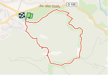
17,7 km | 25 km-effort
4h 40min
![](https://static1.geolcdn.com/siteimages/upload/files/16400158638029165_repeat_loop_refresh_sync_direction_icon.png)
Sí
![Excursión Senderismo Saint-Raphaël - Les lacs par les rochers du Caneiret - Photo](https://media.geolcdn.com/t/375/260/cddead80-47f3-4091-93b3-1398b473dc08.jpg&format=jpg&maxdim=2)
![Senderismo Senderismo](https://static1.geolcdn.com/sitytour/trail-icons/101.png)
Les lacs par les rochers du Caneiret
Senderismo
Medio
(1)
Saint-Raphaël,
Provenza-Alpes-Costa Azul,
Var,
France
![](/images/other/stat-length.png)
20 km | 29 km-effort
5h 7min
![](https://static1.geolcdn.com/siteimages/upload/files/16400158638029165_repeat_loop_refresh_sync_direction_icon.png)
Sí
![Senderismo Senderismo](https://static1.geolcdn.com/sitytour/trail-icons/101.png)
Lac de l'Avelan au départ du col d'Auriasque
Senderismo
Fácil
(2)
Fréjus,
Provenza-Alpes-Costa Azul,
Var,
France
![](/images/other/stat-length.png)
16,6 km | 23 km-effort
5h 39min
![](https://static1.geolcdn.com/siteimages/upload/files/16400158638029165_repeat_loop_refresh_sync_direction_icon.png)
Sí
![Excursión Senderismo Saint-Raphaël - le Dramont - Photo](https://media.geolcdn.com/t/375/260/83d1f287-d047-452c-844a-302c6891c476.jpg&format=jpg&maxdim=2)
![Senderismo Senderismo](https://static1.geolcdn.com/sitytour/trail-icons/101.png)
le Dramont
Senderismo
Medio
(2)
Saint-Raphaël,
Provenza-Alpes-Costa Azul,
Var,
France
![](/images/other/stat-length.png)
5,7 km | 8,3 km-effort
2h 32min
![](https://static1.geolcdn.com/siteimages/upload/files/16400158638029165_repeat_loop_refresh_sync_direction_icon.png)
Sí
![Excursión Bici de montaña Fréjus - grand tour esterel par belles pistes larges - Photo](https://media.geolcdn.com/t/375/260/ext.jpg?maxdim=2&url=https%3A%2F%2Fservices.sitytrail.com%2FGeolivesWS%2FDownloadMedia.ashx%3FTrailID%3D251652%26Media%3Dfix__20140216105744.jpg)
![Bici de montaña Bici de montaña](https://static1.geolcdn.com/sitytour/trail-icons/202.png)
grand tour esterel par belles pistes larges
Bici de montaña
Fácil
(2)
Fréjus,
Provenza-Alpes-Costa Azul,
Var,
France
![](/images/other/stat-length.png)
31 km | 40 km-effort
3h 17min
![](https://static1.geolcdn.com/siteimages/upload/files/16400158638029165_repeat_loop_refresh_sync_direction_icon.png)
Sí
![Excursión Senderismo Saint-Raphaël - Agay - Sainte-Barbe - Étang des Nénuphares - Photo](https://media.geolcdn.com/t/375/260/dfb7073a-02d4-4811-84ba-99dc2878a0d2.jpg&format=jpg&maxdim=2)
![Senderismo Senderismo](https://static1.geolcdn.com/sitytour/trail-icons/101.png)
Agay - Sainte-Barbe - Étang des Nénuphares
Senderismo
Fácil
(2)
Saint-Raphaël,
Provenza-Alpes-Costa Azul,
Var,
France
![](/images/other/stat-length.png)
5 km | 6,2 km-effort
2h 8min
![](https://static1.geolcdn.com/siteimages/upload/files/16400158638029165_repeat_loop_refresh_sync_direction_icon.png)
Sí
![Excursión Senderismo Fréjus - Mont Vinaigre par Colle Douce - Photo](https://media.geolcdn.com/t/375/260/e50e9530-bac2-442d-a80a-5b2b78c05c8e.jpg&format=jpg&maxdim=2)
![Senderismo Senderismo](https://static1.geolcdn.com/sitytour/trail-icons/101.png)
Mont Vinaigre par Colle Douce
Senderismo
Muy difícil
(1)
Fréjus,
Provenza-Alpes-Costa Azul,
Var,
France
![](/images/other/stat-length.png)
22 km | 33 km-effort
6h 1min
![](https://static1.geolcdn.com/siteimages/upload/files/16400158638029165_repeat_loop_refresh_sync_direction_icon.png)
Sí
![Excursión Senderismo Saint-Raphaël - Barre du Roussivau - Sommets des Perthus - Photo](https://media.geolcdn.com/t/375/260/cce5e00e-f52d-40b1-8cb1-0dc22999ece4.jpg&format=jpg&maxdim=2)
![Senderismo Senderismo](https://static1.geolcdn.com/sitytour/trail-icons/101.png)
Barre du Roussivau - Sommets des Perthus
Senderismo
Muy difícil
Saint-Raphaël,
Provenza-Alpes-Costa Azul,
Var,
France
![](/images/other/stat-length.png)
15,7 km | 24 km-effort
5h 22min
![](https://static1.geolcdn.com/siteimages/upload/files/16400158638029165_repeat_loop_refresh_sync_direction_icon.png)
Sí
![Excursión Senderismo Saint-Raphaël - Rando des Etangs - Photo](https://media.geolcdn.com/t/375/260/33bb8feb-dce4-4c92-bacc-ea49f2230fc9.jpg&format=jpg&maxdim=2)
![Senderismo Senderismo](https://static1.geolcdn.com/sitytour/trail-icons/101.png)
Rando des Etangs
Senderismo
Muy difícil
Saint-Raphaël,
Provenza-Alpes-Costa Azul,
Var,
France
![](/images/other/stat-length.png)
16,1 km | 22 km-effort
4h 1min
![](https://static1.geolcdn.com/siteimages/upload/files/16400158638029165_repeat_loop_refresh_sync_direction_icon.png)
Sí