![](/images/other/stat-length.png)
![Excursión Senderismo Galametz - GALAMETZ Le Mont de Wail - Photo](https://media.geolcdn.com/t/1900/400/77be3de3-8192-4488-b457-f0af3c10dd5e.jpg&format=pjpeg&maxdim=2)
GALAMETZ Le Mont de Wail
temmichel
Usuario
![Longitud](/images/other/stat-length.png)
Longitud
13,6 km
![Altitud máxima](https://static1.geolcdn.com/siteimages/upload/files/1508320355ic_sort_altitude_max_24dp.png)
Altitud máxima
105 m
![Desnivel positivo](https://static1.geolcdn.com/siteimages/upload/files/1508320355ic_sort_den_pos_24dp.png)
Desnivel positivo
222 m
![Km-Effort](/images/other/stat-length.png)
Km-Effort
16,5 km
![Altitud mínima](https://static1.geolcdn.com/siteimages/upload/files/1508320355ic_sort_altitude_min_24dp.png)
Altitud mínima
38 m
![Desnivel negativo](https://static1.geolcdn.com/siteimages/upload/files/1508320355ic_sort_den_neg_24dp.png)
Desnivel negativo
222 m
![Boucle](https://static1.geolcdn.com/siteimages/upload/files/16400158638029165_repeat_loop_refresh_sync_direction_icon.png)
Boucle
Sí
Fecha de creación :
2024-04-08 20:29:31.095
Última modificación :
2024-04-08 20:36:39.689
![Senderismo](https://static1.geolcdn.com/sitytour/trail-icons/101.png)
3h45
Dificultad : Difícil
![Escanee este código QR para abrir la excursión en la aplicación SityTrail](https://capi.geolives.com/qq0zvz2zws4bq2lad0pu/sitytour/trails/4009736/qr.png?size=200)
Aplicación GPS de excursión GRATIS
A propósito
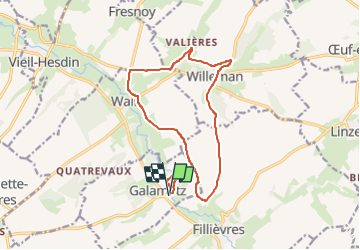
Ruta Senderismo de 13,6 km a descubrir en Alta Francia, Paso de Calais, Galametz. Esta ruta ha sido propuesta por temmichel.
Descripción
Randonnée à travers le Ternois où vous cheminerez sur le GRP CANCHE AUTHIES les deux rivières de cette belle région qui s'écoulent vers la Manche
Bonne randonnée
Jean-Michel
Localización
País:
France
Región :
Alta Francia
Departamento/provincia :
Paso de Calais
Municipio :
Galametz
Localidad:
Unknown
Salida:(Dec)
Salida:(UTM)
438860 ; 5575340 (31U) N.
Comentarios
Excursiones cerca
![Excursión Senderismo Quœux-Haut-Maînil - Quoeux Haut-Mainil - Photo](https://media.geolcdn.com/t/375/260/b2db56ce-03df-4ec6-b825-bdea86080705.jpg&format=jpg&maxdim=2)
![Senderismo Senderismo](https://static1.geolcdn.com/sitytour/trail-icons/101.png)
Quoeux Haut-Mainil
Senderismo
Medio
Quœux-Haut-Maînil,
Alta Francia,
Paso de Calais,
France
![](/images/other/stat-length.png)
19,9 km | 23 km-effort
4h 30min
![](https://static1.geolcdn.com/siteimages/upload/files/16400158638029165_repeat_loop_refresh_sync_direction_icon.png)
Sí
![Excursión Senderismo Vieil-Hesdin - Vieil-Hesdin. Sentier Le Charles Quint - Photo](https://media.geolcdn.com/t/375/260/ext.jpg?maxdim=2&url=https%3A%2F%2Fstatic1.geolcdn.com%2Fsiteimages%2Fupload%2Ffiles%2F1553511878bg_sport_marche.png)
![Senderismo Senderismo](https://static1.geolcdn.com/sitytour/trail-icons/101.png)
Vieil-Hesdin. Sentier Le Charles Quint
Senderismo
Medio
Vieil-Hesdin,
Alta Francia,
Paso de Calais,
France
![](/images/other/stat-length.png)
13,9 km | 16 km-effort
3h 44min
![](https://static1.geolcdn.com/siteimages/upload/files/16400158638029165_repeat_loop_refresh_sync_direction_icon.png)
Sí
![Excursión Senderismo Fillièvres - Boucle de Fillièvres par Conchy sur Canche - Photo](https://media.geolcdn.com/t/375/260/ext.jpg?maxdim=2&url=https%3A%2F%2Fstatic1.geolcdn.com%2Fsiteimages%2Fupload%2Ffiles%2F1553511878bg_sport_marche.png)
![Senderismo Senderismo](https://static1.geolcdn.com/sitytour/trail-icons/101.png)
Boucle de Fillièvres par Conchy sur Canche
Senderismo
Difícil
Fillièvres,
Alta Francia,
Paso de Calais,
France
![](/images/other/stat-length.png)
14,9 km | 17,6 km-effort
4h 0min
![](https://static1.geolcdn.com/siteimages/upload/files/16400158638029165_repeat_loop_refresh_sync_direction_icon.png)
Sí
![Excursión Senderismo Willeman - Boucle de Willeman par la vallée de la Canche - Photo](https://media.geolcdn.com/t/375/260/ext.jpg?maxdim=2&url=https%3A%2F%2Fstatic1.geolcdn.com%2Fsiteimages%2Fupload%2Ffiles%2F1553511878bg_sport_marche.png)
![Senderismo Senderismo](https://static1.geolcdn.com/sitytour/trail-icons/101.png)
Boucle de Willeman par la vallée de la Canche
Senderismo
Difícil
Willeman,
Alta Francia,
Paso de Calais,
France
![](/images/other/stat-length.png)
12,8 km | 15,2 km-effort
3h 27min
![](https://static1.geolcdn.com/siteimages/upload/files/16400158638029165_repeat_loop_refresh_sync_direction_icon.png)
Sí
![Excursión Senderismo Willeman - Boucle de la Canche par Willeman - Photo](https://media.geolcdn.com/t/375/260/ext.jpg?maxdim=2&url=https%3A%2F%2Fstatic1.geolcdn.com%2Fsiteimages%2Fupload%2Ffiles%2F1553511878bg_sport_marche.png)
![Senderismo Senderismo](https://static1.geolcdn.com/sitytour/trail-icons/101.png)
Boucle de la Canche par Willeman
Senderismo
Muy difícil
Willeman,
Alta Francia,
Paso de Calais,
France
![](/images/other/stat-length.png)
16,5 km | 19,2 km-effort
4h 21min
![](https://static1.geolcdn.com/siteimages/upload/files/16400158638029165_repeat_loop_refresh_sync_direction_icon.png)
Sí
![Excursión Senderismo Willeman - Willeman Départ de la ferme du Rossignol - Photo](https://media.geolcdn.com/t/375/260/ext.jpg?maxdim=2&url=https%3A%2F%2Fstatic1.geolcdn.com%2Fsiteimages%2Fupload%2Ffiles%2F1553511878bg_sport_marche.png)
![Senderismo Senderismo](https://static1.geolcdn.com/sitytour/trail-icons/101.png)
Willeman Départ de la ferme du Rossignol
Senderismo
Difícil
Willeman,
Alta Francia,
Paso de Calais,
France
![](/images/other/stat-length.png)
16,6 km | 19 km-effort
4h 10min
![](https://static1.geolcdn.com/siteimages/upload/files/16400158638029165_repeat_loop_refresh_sync_direction_icon.png)
Sí
![Excursión Motor Saint-Georges - pdk2017/3 - Photo](https://media.geolcdn.com/t/375/260/ext.jpg?maxdim=2&url=https%3A%2F%2Fstatic1.geolcdn.com%2Fsiteimages%2Fupload%2Ffiles%2F15247431544x4.jpg)
![Motor Motor](https://static1.geolcdn.com/sitytour/trail-icons/400.png)
pdk2017/3
Motor
Muy fácil
Saint-Georges,
Alta Francia,
Paso de Calais,
France
![](/images/other/stat-length.png)
204 km | 235 km-effort
3h 20min
![](https://static1.geolcdn.com/siteimages/upload/files/16400158638029165_repeat_loop_refresh_sync_direction_icon.png)
No
![Excursión Senderismo Saint-Georges - viel hesdin 2 - Photo](https://media.geolcdn.com/t/375/260/ext.jpg?maxdim=2&url=https%3A%2F%2Fstatic1.geolcdn.com%2Fsiteimages%2Fupload%2Ffiles%2F1553511878bg_sport_marche.png)
![Senderismo Senderismo](https://static1.geolcdn.com/sitytour/trail-icons/101.png)
viel hesdin 2
Senderismo
Fácil
Saint-Georges,
Alta Francia,
Paso de Calais,
France
![](/images/other/stat-length.png)
2,2 km | 2,7 km-effort
1h 6min
![](https://static1.geolcdn.com/siteimages/upload/files/16400158638029165_repeat_loop_refresh_sync_direction_icon.png)
No
![Excursión Senderismo Vieil-Hesdin - viel hesdin - Photo](https://media.geolcdn.com/t/375/260/ext.jpg?maxdim=2&url=https%3A%2F%2Fstatic1.geolcdn.com%2Fsiteimages%2Fupload%2Ffiles%2F1553511878bg_sport_marche.png)
![Senderismo Senderismo](https://static1.geolcdn.com/sitytour/trail-icons/101.png)
viel hesdin
Senderismo
Muy fácil
Vieil-Hesdin,
Alta Francia,
Paso de Calais,
France
![](/images/other/stat-length.png)
2,3 km | 2,5 km-effort
1h 18min
![](https://static1.geolcdn.com/siteimages/upload/files/16400158638029165_repeat_loop_refresh_sync_direction_icon.png)
Sí