![](/images/other/stat-length.png)
![Excursión Senderismo Notre-Dame-de-Bliquetuit - Notre dame de Bliquetuit, le bourg corblin, la mailleraye, Notre dame de Bliquetuit - Photo](https://media.geolcdn.com/t/1900/400/ext.pjpeg?maxdim=2&url=https%3A%2F%2Fstatic1.geolcdn.com%2Fsiteimages%2Fupload%2Ffiles%2F1553511878bg_sport_marche.png)
Notre dame de Bliquetuit, le bourg corblin, la mailleraye, Notre dame de Bliquetuit
Klgmartini@2022
Usuario
![Longitud](/images/other/stat-length.png)
Longitud
9,1 km
![Altitud máxima](https://static1.geolcdn.com/siteimages/upload/files/1508320355ic_sort_altitude_max_24dp.png)
Altitud máxima
46 m
![Desnivel positivo](https://static1.geolcdn.com/siteimages/upload/files/1508320355ic_sort_den_pos_24dp.png)
Desnivel positivo
99 m
![Km-Effort](/images/other/stat-length.png)
Km-Effort
10,5 km
![Altitud mínima](https://static1.geolcdn.com/siteimages/upload/files/1508320355ic_sort_altitude_min_24dp.png)
Altitud mínima
0 m
![Desnivel negativo](https://static1.geolcdn.com/siteimages/upload/files/1508320355ic_sort_den_neg_24dp.png)
Desnivel negativo
99 m
![Boucle](https://static1.geolcdn.com/siteimages/upload/files/16400158638029165_repeat_loop_refresh_sync_direction_icon.png)
Boucle
Sí
Fecha de creación :
2024-04-03 13:18:01.44
Última modificación :
2024-04-03 13:19:57.531
![Senderismo](https://static1.geolcdn.com/sitytour/trail-icons/101.png)
2h22
Dificultad : Medio
![Escanee este código QR para abrir la excursión en la aplicación SityTrail](https://capi.geolives.com/qq0zvz2zws4bq2lad0pu/sitytour/trails/4003116/qr.png?size=200)
Aplicación GPS de excursión GRATIS
A propósito
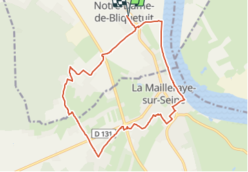
Ruta Senderismo de 9,1 km a descubrir en Normandía, Sena-Marítimo, Notre-Dame-de-Bliquetuit. Esta ruta ha sido propuesta por Klgmartini@2022.
Descripción
Notre dame de Bliquetuit, le bourg corblin, la mailleraye, Notre dame de Bliquetuit
Localización
País:
France
Región :
Normandía
Departamento/provincia :
Sena-Marítimo
Municipio :
Notre-Dame-de-Bliquetuit
Localidad:
Unknown
Salida:(Dec)
Salida:(UTM)
338009 ; 5484782 (31U) N.
Comentarios
Excursiones cerca
![Senderismo Senderismo](https://static1.geolcdn.com/sitytour/trail-icons/101.png)
20230513-Yainville
Senderismo
Medio
Yainville,
Normandía,
Sena-Marítimo,
France
![](/images/other/stat-length.png)
12,4 km | 14 km-effort
3h 52min
![](https://static1.geolcdn.com/siteimages/upload/files/16400158638029165_repeat_loop_refresh_sync_direction_icon.png)
Sí
![Excursión Senderismo Rives-en-Seine - saint marguerite sur duclair - Photo](https://media.geolcdn.com/t/375/260/e79a805c-23a8-4b82-8445-cd3cb02d88fd.jpg&format=jpg&maxdim=2)
![Senderismo Senderismo](https://static1.geolcdn.com/sitytour/trail-icons/101.png)
saint marguerite sur duclair
Senderismo
Medio
Rives-en-Seine,
Normandía,
Sena-Marítimo,
France
![](/images/other/stat-length.png)
6,6 km | 7,3 km-effort
2h 9min
![](https://static1.geolcdn.com/siteimages/upload/files/16400158638029165_repeat_loop_refresh_sync_direction_icon.png)
Sí
![Excursión Senderismo Notre-Dame-de-Bliquetuit - Notre Dame de Bliquetuit vers l'Armada 18km -sans photos - Photo](https://media.geolcdn.com/t/375/260/70cbc6b4-289e-4f31-9eb1-cafb40f9cb50.jpg&format=jpg&maxdim=2)
![Senderismo Senderismo](https://static1.geolcdn.com/sitytour/trail-icons/101.png)
Notre Dame de Bliquetuit vers l'Armada 18km -sans photos
Senderismo
Difícil
Notre-Dame-de-Bliquetuit,
Normandía,
Sena-Marítimo,
France
![](/images/other/stat-length.png)
18,5 km | 20 km-effort
6h 22min
![](https://static1.geolcdn.com/siteimages/upload/files/16400158638029165_repeat_loop_refresh_sync_direction_icon.png)
Sí
![Excursión Senderismo Notre-Dame-de-Bliquetuit - Notre Dame de Bliquetuit vers l'Armada 18km - Photo](https://media.geolcdn.com/t/375/260/70cbc6b4-289e-4f31-9eb1-cafb40f9cb50.jpg&format=jpg&maxdim=2)
![Senderismo Senderismo](https://static1.geolcdn.com/sitytour/trail-icons/101.png)
Notre Dame de Bliquetuit vers l'Armada 18km
Senderismo
Muy difícil
Notre-Dame-de-Bliquetuit,
Normandía,
Sena-Marítimo,
France
![](/images/other/stat-length.png)
18,5 km | 20 km-effort
4h 37min
![](https://static1.geolcdn.com/siteimages/upload/files/16400158638029165_repeat_loop_refresh_sync_direction_icon.png)
Sí
![Excursión Senderismo Notre-Dame-de-Bliquetuit - Notre Dame de Bliquetuit vers l'Armada 18km - Photo](https://media.geolcdn.com/t/375/260/70cbc6b4-289e-4f31-9eb1-cafb40f9cb50.jpg&format=jpg&maxdim=2)
![Senderismo Senderismo](https://static1.geolcdn.com/sitytour/trail-icons/101.png)
Notre Dame de Bliquetuit vers l'Armada 18km
Senderismo
Difícil
Notre-Dame-de-Bliquetuit,
Normandía,
Sena-Marítimo,
France
![](/images/other/stat-length.png)
18,5 km | 20 km-effort
6h 22min
![](https://static1.geolcdn.com/siteimages/upload/files/16400158638029165_repeat_loop_refresh_sync_direction_icon.png)
Sí
![Excursión Senderismo Rives-en-Seine - saint wandrille 76 - Photo](https://media.geolcdn.com/t/375/260/93ae6a7b-c754-44fd-a552-6b50bdaf0db6.jpg&format=jpg&maxdim=2)
![Senderismo Senderismo](https://static1.geolcdn.com/sitytour/trail-icons/101.png)
saint wandrille 76
Senderismo
Medio
Rives-en-Seine,
Normandía,
Sena-Marítimo,
France
![](/images/other/stat-length.png)
8,7 km | 11,5 km-effort
2h 41min
![](https://static1.geolcdn.com/siteimages/upload/files/16400158638029165_repeat_loop_refresh_sync_direction_icon.png)
Sí
![Senderismo Senderismo](https://static1.geolcdn.com/sitytour/trail-icons/101.png)
20220421-Caudebec en Caux Journée
Senderismo
Medio
Rives-en-Seine,
Normandía,
Sena-Marítimo,
France
![](/images/other/stat-length.png)
21 km | 27 km-effort
6h 34min
![](https://static1.geolcdn.com/siteimages/upload/files/16400158638029165_repeat_loop_refresh_sync_direction_icon.png)
Sí
![Excursión Senderismo Yainville - 20210708-Yainville - Photo](https://media.geolcdn.com/t/375/260/7a3f9508-f365-411b-b734-695f75e8459f.jpg&format=jpg&maxdim=2)
![Senderismo Senderismo](https://static1.geolcdn.com/sitytour/trail-icons/101.png)
20210708-Yainville
Senderismo
Medio
Yainville,
Normandía,
Sena-Marítimo,
France
![](/images/other/stat-length.png)
23 km | 27 km-effort
6h 6min
![](https://static1.geolcdn.com/siteimages/upload/files/16400158638029165_repeat_loop_refresh_sync_direction_icon.png)
Sí
![Excursión Senderismo Notre-Dame-de-Bliquetuit - Notre Dame de Bliquetuit - Photo](https://media.geolcdn.com/t/375/260/ext.jpg?maxdim=2&url=https%3A%2F%2Fservices.sitytrail.com%2FGeolivesWS%2FDownloadMedia.ashx%3FTrailID%3D1136395%26Media%3Dfix__20190418180542.jpg)
![Senderismo Senderismo](https://static1.geolcdn.com/sitytour/trail-icons/101.png)
Notre Dame de Bliquetuit
Senderismo
Muy fácil
Notre-Dame-de-Bliquetuit,
Normandía,
Sena-Marítimo,
France
![](/images/other/stat-length.png)
13,8 km | 15,5 km-effort
3h 25min
![](https://static1.geolcdn.com/siteimages/upload/files/16400158638029165_repeat_loop_refresh_sync_direction_icon.png)
Sí