![](/images/other/stat-length.png)
![Excursión Senderismo Prévenchères - Gorges de Chassezac - Photo](https://media.geolcdn.com/t/1900/400/49ddc4e4-e66c-491b-9c51-4f66b0d6413a.jpg&format=pjpeg&maxdim=2)
Gorges de Chassezac
cousam
Usuario
![Longitud](/images/other/stat-length.png)
![Altitud máxima](https://static1.geolcdn.com/siteimages/upload/files/1508320355ic_sort_altitude_max_24dp.png)
![Desnivel positivo](https://static1.geolcdn.com/siteimages/upload/files/1508320355ic_sort_den_pos_24dp.png)
![Km-Effort](/images/other/stat-length.png)
![Altitud mínima](https://static1.geolcdn.com/siteimages/upload/files/1508320355ic_sort_altitude_min_24dp.png)
![Desnivel negativo](https://static1.geolcdn.com/siteimages/upload/files/1508320355ic_sort_den_neg_24dp.png)
![Boucle](https://static1.geolcdn.com/siteimages/upload/files/16400158638029165_repeat_loop_refresh_sync_direction_icon.png)
![Senderismo](https://static1.geolcdn.com/sitytour/trail-icons/101.png)
7h33
Dificultad : Difícil
![Escanee este código QR para abrir la excursión en la aplicación SityTrail](https://capi.geolives.com/qq0zvz2zws4bq2lad0pu/sitytour/trails/4001113/qr.png?size=200)
Aplicación GPS de excursión GRATIS
A propósito
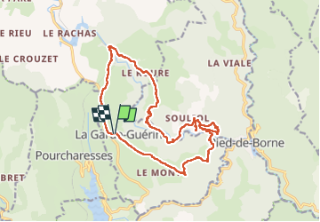
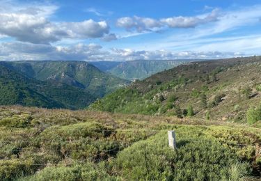
Ruta Senderismo de 19 km a descubrir en Occitania, Lozère, Prévenchères. Esta ruta ha sido propuesta por cousam.
Descripción
Rando effectuée après de grosses pluies tombées la veille (160mm).
Impossible de passer les gués au km 6 fait 1/2 tour et au Km 14 de redescendre le sentier direct pour la Garde Guérin, car le gué était inaccessible.
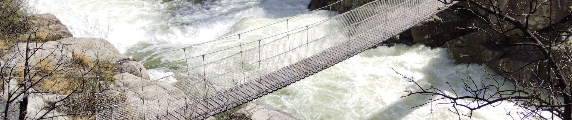
Par contre super le torrent Chassezac gonflé par cette crue.
Localización
Comentarios
Excursiones cerca
![Excursión Senderismo Prévenchères - GRP Tour du Chassezac en 2 jours - Photo](https://media.geolcdn.com/t/375/260/84d555a1-bdfe-4680-a9a0-8edf1eee0bac.jpg&format=jpg&maxdim=2)
![Senderismo Senderismo](https://static1.geolcdn.com/sitytour/trail-icons/101.png)
Senderismo
![](/images/other/stat-length.png)
![](https://static1.geolcdn.com/siteimages/upload/files/16400158638029165_repeat_loop_refresh_sync_direction_icon.png)
![Excursión Senderismo Pied-de-Borne - GRP Tour du Chassezac en 2 jours - Photo](https://media.geolcdn.com/t/375/260/4939cb41-dd3b-4cb9-aebc-74687e919567.jpg&format=jpg&maxdim=2)
![Senderismo Senderismo](https://static1.geolcdn.com/sitytour/trail-icons/101.png)
Senderismo
![](/images/other/stat-length.png)
![](https://static1.geolcdn.com/siteimages/upload/files/16400158638029165_repeat_loop_refresh_sync_direction_icon.png)
![Excursión Senderismo Pourcharesses - au coeur des gorges du chassezac au départ de Villefort - Photo](https://media.geolcdn.com/t/375/260/648a2635-721c-411c-9b65-d15697fb8c14.jpg&format=jpg&maxdim=2)
![Senderismo Senderismo](https://static1.geolcdn.com/sitytour/trail-icons/101.png)
Senderismo
![](/images/other/stat-length.png)
![](https://static1.geolcdn.com/siteimages/upload/files/16400158638029165_repeat_loop_refresh_sync_direction_icon.png)
![Excursión Senderismo Pied-de-Borne - Le tour du Chassezac - Photo](https://media.geolcdn.com/t/375/260/befb1c71-a310-40db-8e8f-df4d5ec91bd5.jpg&format=jpg&maxdim=2)
![Senderismo Senderismo](https://static1.geolcdn.com/sitytour/trail-icons/101.png)
Senderismo
![](/images/other/stat-length.png)
![](https://static1.geolcdn.com/siteimages/upload/files/16400158638029165_repeat_loop_refresh_sync_direction_icon.png)
![Excursión Senderismo Pied-de-Borne - Le tour du chassezac - Photo](https://media.geolcdn.com/t/375/260/34d1863b-5946-4591-908e-d59df5d48945.jpg&format=jpg&maxdim=2)
![Senderismo Senderismo](https://static1.geolcdn.com/sitytour/trail-icons/101.png)
Senderismo
![](/images/other/stat-length.png)
![](https://static1.geolcdn.com/siteimages/upload/files/16400158638029165_repeat_loop_refresh_sync_direction_icon.png)
![Excursión Senderismo Prévenchères - La garde guerin - Photo](https://media.geolcdn.com/t/375/260/f4d5d102-7541-4721-bc49-35572d8c8339.jpg&format=jpg&maxdim=2)
![Senderismo Senderismo](https://static1.geolcdn.com/sitytour/trail-icons/101.png)
Senderismo
![](/images/other/stat-length.png)
![](https://static1.geolcdn.com/siteimages/upload/files/16400158638029165_repeat_loop_refresh_sync_direction_icon.png)
![Excursión Senderismo Prévenchères - Gorges du Chassezac au départ de la Garde guérin - Photo](https://media.geolcdn.com/t/375/260/1d0812e0-004d-45c5-80f3-cf534f71bab6.jpg&format=jpg&maxdim=2)
![Senderismo Senderismo](https://static1.geolcdn.com/sitytour/trail-icons/101.png)
Senderismo
![](/images/other/stat-length.png)
![](https://static1.geolcdn.com/siteimages/upload/files/16400158638029165_repeat_loop_refresh_sync_direction_icon.png)
![Excursión Senderismo Prévenchères - La Garde Guerin - Photo](https://media.geolcdn.com/t/375/260/d0963631-787c-4221-b6f7-68f04bbfe444.jpg&format=jpg&maxdim=2)
![Senderismo Senderismo](https://static1.geolcdn.com/sitytour/trail-icons/101.png)
Senderismo
![](/images/other/stat-length.png)
![](https://static1.geolcdn.com/siteimages/upload/files/16400158638029165_repeat_loop_refresh_sync_direction_icon.png)
![Excursión Senderismo Pourcharesses - tour du lac de Villefort et chapelle Saint Loup. - Photo](https://media.geolcdn.com/t/375/260/b396c6ba-ce51-416e-9a24-1c821bca4376.jpg&format=jpg&maxdim=2)
![Senderismo Senderismo](https://static1.geolcdn.com/sitytour/trail-icons/101.png)
Senderismo
![](/images/other/stat-length.png)
![](https://static1.geolcdn.com/siteimages/upload/files/16400158638029165_repeat_loop_refresh_sync_direction_icon.png)