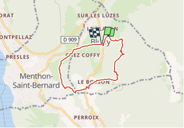
![](/images/other/stat-length.png)
![Excursión Bluffy - Cascades-de-montviard - Photo](https://media.geolcdn.com/t/1900/400/ext.pjpeg?maxdim=2&url=https%3A%2F%2Fsecurestorage.geolives.com%2Fsitytour%2Ftrail-bg%2Fdefault.jpg)
Cascades-de-montviard
pfloquet
Usuario
![Longitud](/images/other/stat-length.png)
![Boucle](https://static1.geolcdn.com/siteimages/upload/files/16400158638029165_repeat_loop_refresh_sync_direction_icon.png)
![Escanee este código QR para abrir la excursión en la aplicación SityTrail](https://capi.geolives.com/qq0zvz2zws4bq2lad0pu/sitytour/trails/3997625/qr.png?size=200)
Aplicación GPS de excursión GRATIS
A propósito
Ruta de 6 km a descubrir en Auvergne-Rhône-Alpes, Alta Saboya, Bluffy. Esta ruta ha sido propuesta por pfloquet.
Descripción
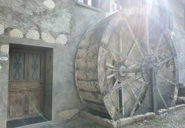
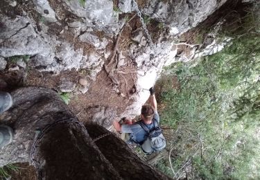
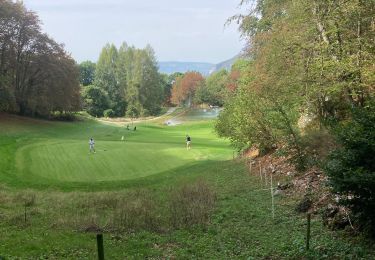
Cette boucle députe dans le village de Gruffy, le parcours gagne de la hauteur à travers la forêt pour atteindre les cascades de Montviard puis un premier point de vue sur le lac et le massif des Bauges, la descente se fait ensuite sur les hameaux du Bosson puis du Ramponnet et enfin, un beau sentier longe les jeunes vignobles du Château de Menthon Saint-Bernard.
Cette randonnée pour marcheurs moyens est un beau compromis entre nature et patrimoine rurale.
Informations pratiques :
Randonnée à ne pas entreprendre en hiver, le bas des cascades est recouvert de glace, la traversée des ruisseaux est dangereuse
parking centre village face à la mairie.
Chaussures de marche conseillées
Localización
Comentarios
Excursiones cerca
![Excursión Senderismo Talloires-Montmin - col de l aulp rocher de l ancrenaz - Photo](https://media.geolcdn.com/t/375/260/ext.jpg?maxdim=2&url=https%3A%2F%2Fservices.sitytrail.com%2FGeolivesWS%2FDownloadMedia.ashx%3FTrailID%3D71648%26Media%3D20110813123327.jpg)
![Senderismo Senderismo](https://static1.geolcdn.com/sitytour/trail-icons/101.png)
Senderismo
![](/images/other/stat-length.png)
![](https://static1.geolcdn.com/siteimages/upload/files/16400158638029165_repeat_loop_refresh_sync_direction_icon.png)
![Excursión Senderismo Veyrier-du-Lac - 74 Mt Veyrier 26.06.23 - Photo](https://media.geolcdn.com/t/375/260/e7069dc2-0437-4294-a5ae-f7942e994b91.jpg&format=jpg&maxdim=2)
![Senderismo Senderismo](https://static1.geolcdn.com/sitytour/trail-icons/101.png)
Senderismo
![](/images/other/stat-length.png)
![](https://static1.geolcdn.com/siteimages/upload/files/16400158638029165_repeat_loop_refresh_sync_direction_icon.png)
![Excursión Senderismo Saint-Jorioz - Saint Jorioz - Boucle du Laudon - Photo](https://media.geolcdn.com/t/375/260/9c7ab231-8d9b-40ca-b746-90a001c95581.jpg&format=jpg&maxdim=2)
![Senderismo Senderismo](https://static1.geolcdn.com/sitytour/trail-icons/101.png)
Senderismo
![](/images/other/stat-length.png)
![](https://static1.geolcdn.com/siteimages/upload/files/16400158638029165_repeat_loop_refresh_sync_direction_icon.png)
![Excursión Senderismo Alex - trou de la chapelle (Alex) - Photo](https://media.geolcdn.com/t/375/260/e4e5cc10-f309-4895-b6ad-f846bda4e394.jpg&format=jpg&maxdim=2)
![Senderismo Senderismo](https://static1.geolcdn.com/sitytour/trail-icons/101.png)
Senderismo
![](/images/other/stat-length.png)
![](https://static1.geolcdn.com/siteimages/upload/files/16400158638029165_repeat_loop_refresh_sync_direction_icon.png)
![Excursión Senderismo Talloires-Montmin - Talloires ermitage - Photo](https://media.geolcdn.com/t/375/260/77ff74c7-d0fd-4288-91f7-c6b5192ad2e9.jpeg&format=jpg&maxdim=2)
![Senderismo Senderismo](https://static1.geolcdn.com/sitytour/trail-icons/101.png)
Senderismo
![](/images/other/stat-length.png)
![](https://static1.geolcdn.com/siteimages/upload/files/16400158638029165_repeat_loop_refresh_sync_direction_icon.png)
![Excursión Senderismo Talloires-Montmin - la tournette par le mamelon Vert en boucle - Photo](https://media.geolcdn.com/t/375/260/c6b8a3e7-0159-4749-9282-27f4103f0d08.jpg&format=jpg&maxdim=2)
![Senderismo Senderismo](https://static1.geolcdn.com/sitytour/trail-icons/101.png)
Senderismo
![](/images/other/stat-length.png)
![](https://static1.geolcdn.com/siteimages/upload/files/16400158638029165_repeat_loop_refresh_sync_direction_icon.png)
![Excursión Senderismo Talloires-Montmin - au dessus d Aulp - Photo](https://media.geolcdn.com/t/375/260/7be8cdf3-9819-4565-8c5b-7059763ed20c.jpg&format=jpg&maxdim=2)
![Senderismo Senderismo](https://static1.geolcdn.com/sitytour/trail-icons/101.png)
Senderismo
![](/images/other/stat-length.png)
![](https://static1.geolcdn.com/siteimages/upload/files/16400158638029165_repeat_loop_refresh_sync_direction_icon.png)
![Excursión Senderismo Talloires-Montmin - Aulp-La Tournette - Photo](https://media.geolcdn.com/t/375/260/ext.jpg?maxdim=2&url=https%3A%2F%2Fstatic1.geolcdn.com%2Fsiteimages%2Fupload%2Ffiles%2F1553511878bg_sport_marche.png)
![Senderismo Senderismo](https://static1.geolcdn.com/sitytour/trail-icons/101.png)
Senderismo
![](/images/other/stat-length.png)
![](https://static1.geolcdn.com/siteimages/upload/files/16400158638029165_repeat_loop_refresh_sync_direction_icon.png)
![Excursión Senderismo Talloires-Montmin - Annecy - Photo](https://media.geolcdn.com/t/375/260/a7107db8-ef01-4a74-856b-053da3e36a3e.jpg&format=jpg&maxdim=2)
![Senderismo Senderismo](https://static1.geolcdn.com/sitytour/trail-icons/101.png)
Senderismo
![](/images/other/stat-length.png)
![](https://static1.geolcdn.com/siteimages/upload/files/16400158638029165_repeat_loop_refresh_sync_direction_icon.png)