![](/images/other/stat-length.png)
![Excursión Senderismo Barbières - Traversée Barbières Beauregard-Baret - Photo](https://media.geolcdn.com/t/1900/400/2a3121e4-a036-4b19-8247-21a832e98ad8.jpg&format=pjpeg&maxdim=2)
Traversée Barbières Beauregard-Baret
GuyVachet
Usuario
![Longitud](/images/other/stat-length.png)
Longitud
17 km
![Altitud máxima](https://static1.geolcdn.com/siteimages/upload/files/1508320355ic_sort_altitude_max_24dp.png)
Altitud máxima
879 m
![Desnivel positivo](https://static1.geolcdn.com/siteimages/upload/files/1508320355ic_sort_den_pos_24dp.png)
Desnivel positivo
826 m
![Km-Effort](/images/other/stat-length.png)
Km-Effort
28 km
![Altitud mínima](https://static1.geolcdn.com/siteimages/upload/files/1508320355ic_sort_altitude_min_24dp.png)
Altitud mínima
421 m
![Desnivel negativo](https://static1.geolcdn.com/siteimages/upload/files/1508320355ic_sort_den_neg_24dp.png)
Desnivel negativo
837 m
![Boucle](https://static1.geolcdn.com/siteimages/upload/files/16400158638029165_repeat_loop_refresh_sync_direction_icon.png)
Boucle
No
Fecha de creación :
2024-03-21 08:04:00.073
Última modificación :
2024-03-22 07:28:37.102
![Senderismo](https://static1.geolcdn.com/sitytour/trail-icons/101.png)
7h09
Dificultad : Muy difícil
![Escanee este código QR para abrir la excursión en la aplicación SityTrail](https://capi.geolives.com/qq0zvz2zws4bq2lad0pu/sitytour/trails/3989159/qr.png?size=200)
Aplicación GPS de excursión GRATIS
A propósito
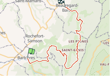
Ruta Senderismo de 17 km a descubrir en Auvergne-Rhône-Alpes, Drôme, Barbières. Esta ruta ha sido propuesta por GuyVachet.
Descripción
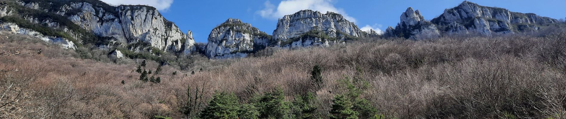
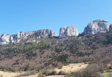
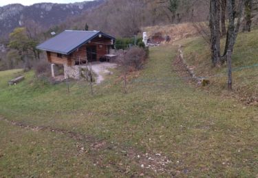
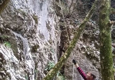
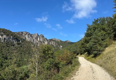
Traversée au pied des Monts du Matin. Ces premiers contreforts du Vercors marquant l'entrée dans les Alpes depuis la Vallée du Rhône.
Localización
País:
France
Región :
Auvergne-Rhône-Alpes
Departamento/provincia :
Drôme
Municipio :
Barbières
Localidad:
Unknown
Salida:(Dec)
Salida:(UTM)
668931 ; 4980288 (31T) N.
Comentarios
Excursiones cerca
![Excursión Senderismo Beauregard-Baret - Pré de Cinq Sous - Beauregard Baret - Photo](https://media.geolcdn.com/t/375/260/ext.jpg?maxdim=2&url=https%3A%2F%2Fservices.sitytrail.com%2FGeolivesWS%2FDownloadMedia.ashx%3FTrailID%3D214828%26Media%3D15342_3.jpg)
![Senderismo Senderismo](https://static1.geolcdn.com/sitytour/trail-icons/101.png)
Pré de Cinq Sous - Beauregard Baret
Senderismo
Medio
(1)
Beauregard-Baret,
Auvergne-Rhône-Alpes,
Drôme,
France
![](/images/other/stat-length.png)
11,6 km | 23 km-effort
5h 0min
![](https://static1.geolcdn.com/siteimages/upload/files/16400158638029165_repeat_loop_refresh_sync_direction_icon.png)
Sí
![Excursión Senderismo Rochefort-Samson - Les Vachères - Combe d'oyans - Photo](https://media.geolcdn.com/t/375/260/b496d0d5-f9c5-4087-8105-422c092be197.jpg&format=jpg&maxdim=2)
![Senderismo Senderismo](https://static1.geolcdn.com/sitytour/trail-icons/101.png)
Les Vachères - Combe d'oyans
Senderismo
Difícil
(1)
Rochefort-Samson,
Auvergne-Rhône-Alpes,
Drôme,
France
![](/images/other/stat-length.png)
17,1 km | 28 km-effort
8h 26min
![](https://static1.geolcdn.com/siteimages/upload/files/16400158638029165_repeat_loop_refresh_sync_direction_icon.png)
Sí
![Excursión Senderismo Saint-Vincent-la-Commanderie - Pierre Chauve 1308m, les Roches de Treillaras, depuis les Condamines - Photo](https://media.geolcdn.com/t/375/260/ext.jpg?maxdim=2&url=https%3A%2F%2Fservices.sitytrail.com%2FGeolivesWS%2FDownloadMedia.ashx%3FTrailID%3D318111%26Media%3D17572_1.jpg)
![Senderismo Senderismo](https://static1.geolcdn.com/sitytour/trail-icons/101.png)
Pierre Chauve 1308m, les Roches de Treillaras, depuis les Condamines
Senderismo
Medio
(2)
Saint-Vincent-la-Commanderie,
Auvergne-Rhône-Alpes,
Drôme,
France
![](/images/other/stat-length.png)
12,7 km | 25 km-effort
6h 30min
![](https://static1.geolcdn.com/siteimages/upload/files/16400158638029165_repeat_loop_refresh_sync_direction_icon.png)
Sí
![Excursión Senderismo Beauregard-Baret - reco cx st Gervais b baret - Photo](https://media.geolcdn.com/t/375/260/62f4b6af-f36d-4d7e-9bf7-cff82879ff65.jpg&format=jpg&maxdim=2)
![Senderismo Senderismo](https://static1.geolcdn.com/sitytour/trail-icons/101.png)
reco cx st Gervais b baret
Senderismo
Difícil
Beauregard-Baret,
Auvergne-Rhône-Alpes,
Drôme,
France
![](/images/other/stat-length.png)
9,4 km | 16,2 km-effort
4h 58min
![](https://static1.geolcdn.com/siteimages/upload/files/16400158638029165_repeat_loop_refresh_sync_direction_icon.png)
No
![Excursión Senderismo Saint-Vincent-la-Commanderie - 26 st Vincent commanderie zel - Photo](https://media.geolcdn.com/t/375/260/64d0078a-2be9-41db-957b-395e9e3d9a48.jpg&format=jpg&maxdim=2)
![Senderismo Senderismo](https://static1.geolcdn.com/sitytour/trail-icons/101.png)
26 st Vincent commanderie zel
Senderismo
Fácil
Saint-Vincent-la-Commanderie,
Auvergne-Rhône-Alpes,
Drôme,
France
![](/images/other/stat-length.png)
14,2 km | 22 km-effort
6h 5min
![](https://static1.geolcdn.com/siteimages/upload/files/16400158638029165_repeat_loop_refresh_sync_direction_icon.png)
Sí
![Excursión Senderismo Beauregard-Baret - croix st Gervais et Pas du loup - Photo](https://media.geolcdn.com/t/375/260/31db5131-e481-415d-9c06-0a841965de22.jpg&format=jpg&maxdim=2)
![Senderismo Senderismo](https://static1.geolcdn.com/sitytour/trail-icons/101.png)
croix st Gervais et Pas du loup
Senderismo
Medio
Beauregard-Baret,
Auvergne-Rhône-Alpes,
Drôme,
France
![](/images/other/stat-length.png)
10 km | 16,9 km-effort
5h 4min
![](https://static1.geolcdn.com/siteimages/upload/files/16400158638029165_repeat_loop_refresh_sync_direction_icon.png)
No
![Excursión Senderismo Léoncel - Pierre Chauve depuis le Col de Tourniol - Photo](https://media.geolcdn.com/t/375/260/ext.jpg?maxdim=2&url=https%3A%2F%2Fstatic1.geolcdn.com%2Fsiteimages%2Fupload%2Ffiles%2F1553511878bg_sport_marche.png)
![Senderismo Senderismo](https://static1.geolcdn.com/sitytour/trail-icons/101.png)
Pierre Chauve depuis le Col de Tourniol
Senderismo
Fácil
(3)
Léoncel,
Auvergne-Rhône-Alpes,
Drôme,
France
![](/images/other/stat-length.png)
7,9 km | 12,3 km-effort
2h 52min
![](https://static1.geolcdn.com/siteimages/upload/files/16400158638029165_repeat_loop_refresh_sync_direction_icon.png)
Sí
![Excursión Senderismo Barbières - 26 pierre chauve barbieres zel - Photo](https://media.geolcdn.com/t/375/260/92caf138-cce3-4645-835e-f3491e5ff577.jpg&format=jpg&maxdim=2)
![Senderismo Senderismo](https://static1.geolcdn.com/sitytour/trail-icons/101.png)
26 pierre chauve barbieres zel
Senderismo
Medio
Barbières,
Auvergne-Rhône-Alpes,
Drôme,
France
![](/images/other/stat-length.png)
13,8 km | 26 km-effort
7h 9min
![](https://static1.geolcdn.com/siteimages/upload/files/16400158638029165_repeat_loop_refresh_sync_direction_icon.png)
No
![Excursión sport Beauregard-Baret - Pierre rousse pas de pourceau l’eau basse - Photo](https://media.geolcdn.com/t/375/260/8f7985a7-111f-4318-9d67-55ef317841a8.jpg&format=jpg&maxdim=2)
Pierre rousse pas de pourceau l’eau basse
sport
Muy fácil
Beauregard-Baret,
Auvergne-Rhône-Alpes,
Drôme,
France
![](/images/other/stat-length.png)
14,7 km | 28 km-effort
Desconocido
![](https://static1.geolcdn.com/siteimages/upload/files/16400158638029165_repeat_loop_refresh_sync_direction_icon.png)
Sí