CUNFIN (10) - La grande Cystercienne SityTrail > Excursiones > Outdoor > France > Gran Este > Aube > Cunfin SityTrail > Excursiones > Outdoor > France > Gran Este > Aube > Cunfin CUNFIN (10) - La grande Cystercienne temmichel Usuario 3D © OpenStreetMap contributors Longitud 13,7 km Altitud máxima 358 m Desnivel positivo 288 m Km-Effort 17,5 km Altitud mínima 247 m Desnivel negativo 281 m Boucle Sí Fecha de creación : 2024-03-18 21:12:44.8 Última modificación : 2024-03-18 21:12:44.8 (0 Opinión) Senderismo 3h58 Dificultad : Difícil Aplicación GPS de excursión GRATIS SityTrail IGN / Institutos geográficos SityTrail World El mundo es suyo A propósito Ruta Senderismo de 13,7 km a descubrir en Gran Este, Aube, Cunfin. Esta ruta ha sido propuesta por temmichel. Leyendas | Más detalles (PDF) Perfil altimétrico Leyendas > 15% 15% - 10% 10% - 5% plano 5% - 10% 10% - 15% 15% - 30% > 30% Localización País: France Región : Gran Este Departamento/provincia : Aube Municipio : Cunfin Localidad: Unknown Salida:(Dec) 48.040428 / 4.667752999999999 Salida:(UTM) 624308 ; 5322139 (31U) N. Comentarios Por favor conéctese para dejar un comentario o una evaluación Excursiones cerca tracegps Le Val Fontaine entre l'Aube, la Haute-Marne et la Côte d'Or Senderismo Medio Cunfin, Gran Este, Aube, France 
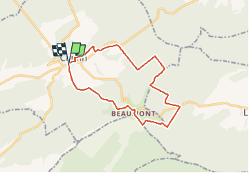
11 km | 14 km-effort 2h 15min Sí temmichel CUNFIN (Aube) Le Landion Senderismo Difícil Cunfin, Gran Este, Aube, France 11,3 km | 14,4 km-effort 3h 16min Sí genndor Cunfin 2 Senderismo Muy difícil Cunfin, Gran Este, Aube, France 20 km | 25 km-effort 5h 44min Sí