![](/images/other/stat-length.png)
![Excursión Senderismo Meaux - SityTrail - GR15 ttrace - Photo](https://media.geolcdn.com/t/1900/400/ext.pjpeg?maxdim=2&url=https%3A%2F%2Fstatic1.geolcdn.com%2Fsiteimages%2Fupload%2Ffiles%2F1553511878bg_sport_marche.png)
SityTrail - GR15 ttrace
clalaur
Usuario
![Longitud](/images/other/stat-length.png)
Longitud
15,7 km
![Altitud máxima](https://static1.geolcdn.com/siteimages/upload/files/1508320355ic_sort_altitude_max_24dp.png)
Altitud máxima
136 m
![Desnivel positivo](https://static1.geolcdn.com/siteimages/upload/files/1508320355ic_sort_den_pos_24dp.png)
Desnivel positivo
224 m
![Km-Effort](/images/other/stat-length.png)
Km-Effort
18,6 km
![Altitud mínima](https://static1.geolcdn.com/siteimages/upload/files/1508320355ic_sort_altitude_min_24dp.png)
Altitud mínima
46 m
![Desnivel negativo](https://static1.geolcdn.com/siteimages/upload/files/1508320355ic_sort_den_neg_24dp.png)
Desnivel negativo
214 m
![Boucle](https://static1.geolcdn.com/siteimages/upload/files/16400158638029165_repeat_loop_refresh_sync_direction_icon.png)
Boucle
No
Fecha de creación :
2024-03-15 17:16:31.038
Última modificación :
2024-07-26 13:31:37.061
![Senderismo](https://static1.geolcdn.com/sitytour/trail-icons/101.png)
4h13
Dificultad : Difícil
![Escanee este código QR para abrir la excursión en la aplicación SityTrail](https://capi.geolives.com/qq0zvz2zws4bq2lad0pu/sitytour/trails/3982083/qr.png?size=200)
Aplicación GPS de excursión GRATIS
A propósito
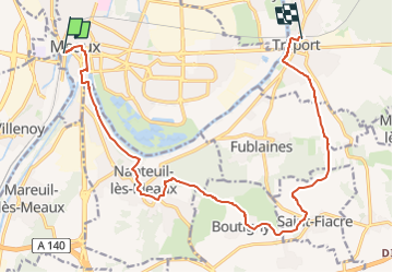
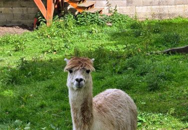
Ruta Senderismo de 15,7 km a descubrir en Isla de Francia, Sena y Marne, Meaux. Esta ruta ha sido propuesta por clalaur.
Descripción
Randonnée faite le vendredi 26 juillet 2024.
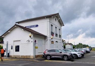
Départ : gare de Meaux (Train P) Meaux ; Arrivée : garde Trilport (Train P) Trilport.
Localización
País:
France
Región :
Isla de Francia
Departamento/provincia :
Sena y Marne
Municipio :
Meaux
Localidad:
Unknown
Salida:(Dec)
Salida:(UTM)
490761 ; 5422664 (31U) N.
Comentarios
Excursiones cerca
![Excursión Senderismo Crégy-lès-Meaux - SM_CREGY-LES-MEAUX_8Km - Photo](https://media.geolcdn.com/t/375/260/4a1646b8-cb34-4e33-b775-fb442311006b.jpg&format=jpg&maxdim=2)
![Senderismo Senderismo](https://static1.geolcdn.com/sitytour/trail-icons/101.png)
SM_CREGY-LES-MEAUX_8Km
Senderismo
Medio
(8)
Crégy-lès-Meaux,
Isla de Francia,
Sena y Marne,
France
![](/images/other/stat-length.png)
7,8 km | 9,2 km-effort
2h 5min
![](https://static1.geolcdn.com/siteimages/upload/files/16400158638029165_repeat_loop_refresh_sync_direction_icon.png)
Sí
![Excursión Bici de montaña Nanteuil-lès-Meaux - tite boucle Nanteuil par l'eau - Photo](https://media.geolcdn.com/t/375/260/ext.jpg?maxdim=2&url=https%3A%2F%2Fservices.sitytrail.com%2FGeolivesWS%2FDownloadMedia.ashx%3FTrailID%3D263705%26Media%3Dfix__20140406122359.jpg)
![Bici de montaña Bici de montaña](https://static1.geolcdn.com/sitytour/trail-icons/202.png)
tite boucle Nanteuil par l'eau
Bici de montaña
Fácil
(1)
Nanteuil-lès-Meaux,
Isla de Francia,
Sena y Marne,
France
![](/images/other/stat-length.png)
23 km | 26 km-effort
1h 48min
![](https://static1.geolcdn.com/siteimages/upload/files/16400158638029165_repeat_loop_refresh_sync_direction_icon.png)
Sí
![Excursión Senderismo Meaux - SM_MEAUX_LePâtis_8km. - Photo](https://media.geolcdn.com/t/375/260/59d59af8-64ac-4cd9-8525-6af37371405a.jpg&format=jpg&maxdim=2)
![Senderismo Senderismo](https://static1.geolcdn.com/sitytour/trail-icons/101.png)
SM_MEAUX_LePâtis_8km.
Senderismo
Fácil
(3)
Meaux,
Isla de Francia,
Sena y Marne,
France
![](/images/other/stat-length.png)
7,9 km | 8,4 km-effort
1h 54min
![](https://static1.geolcdn.com/siteimages/upload/files/16400158638029165_repeat_loop_refresh_sync_direction_icon.png)
Sí
![Excursión Senderismo Meaux - Le chemin de St Colomban en Ile de France Etape 3 Jouarre Meaux - Photo](https://media.geolcdn.com/t/375/260/17b30d06-8e11-4bee-afb1-3cf425f57ffe.jpg&format=jpg&maxdim=2)
![Senderismo Senderismo](https://static1.geolcdn.com/sitytour/trail-icons/101.png)
Le chemin de St Colomban en Ile de France Etape 3 Jouarre Meaux
Senderismo
Muy difícil
Meaux,
Isla de Francia,
Sena y Marne,
France
![](/images/other/stat-length.png)
36 km | 43 km-effort
9h 41min
![](https://static1.geolcdn.com/siteimages/upload/files/16400158638029165_repeat_loop_refresh_sync_direction_icon.png)
No
![Excursión Senderismo Meaux - Le tour du Grand Paris via le GR1 - Etape 10 Meaux Mortcerf - Photo](https://media.geolcdn.com/t/375/260/bf5605a3-71d6-489a-a1f1-655ab44fd4d2.jpg&format=jpg&maxdim=2)
![Senderismo Senderismo](https://static1.geolcdn.com/sitytour/trail-icons/101.png)
Le tour du Grand Paris via le GR1 - Etape 10 Meaux Mortcerf
Senderismo
Difícil
Meaux,
Isla de Francia,
Sena y Marne,
France
![](/images/other/stat-length.png)
34 km | 40 km-effort
6h 35min
![](https://static1.geolcdn.com/siteimages/upload/files/16400158638029165_repeat_loop_refresh_sync_direction_icon.png)
No
![Excursión Senderismo Meaux - Canal autour de Meaux - Photo](https://media.geolcdn.com/t/375/260/ext.jpg?maxdim=2&url=https%3A%2F%2Fstatic1.geolcdn.com%2Fsiteimages%2Fupload%2Ffiles%2F1553511878bg_sport_marche.png)
![Senderismo Senderismo](https://static1.geolcdn.com/sitytour/trail-icons/101.png)
Canal autour de Meaux
Senderismo
Fácil
(1)
Meaux,
Isla de Francia,
Sena y Marne,
France
![](/images/other/stat-length.png)
11,4 km | 12,3 km-effort
2h 51min
![](https://static1.geolcdn.com/siteimages/upload/files/16400158638029165_repeat_loop_refresh_sync_direction_icon.png)
Sí
![Excursión Senderismo Chambry - Chambry Grand Parcours - Photo](https://media.geolcdn.com/t/375/260/ext.jpg?maxdim=2&url=https%3A%2F%2Fstatic1.geolcdn.com%2Fsiteimages%2Fupload%2Ffiles%2F1553511878bg_sport_marche.png)
![Senderismo Senderismo](https://static1.geolcdn.com/sitytour/trail-icons/101.png)
Chambry Grand Parcours
Senderismo
Fácil
(2)
Chambry,
Isla de Francia,
Sena y Marne,
France
![](/images/other/stat-length.png)
18,3 km | 20 km-effort
4h 29min
![](https://static1.geolcdn.com/siteimages/upload/files/16400158638029165_repeat_loop_refresh_sync_direction_icon.png)
Sí
![Excursión Senderismo Meaux - MEAUX BOUCLE 19 KM - Photo](https://media.geolcdn.com/t/375/260/ext.jpg?maxdim=2&url=https%3A%2F%2Fstatic1.geolcdn.com%2Fsiteimages%2Fupload%2Ffiles%2F1553511878bg_sport_marche.png)
![Senderismo Senderismo](https://static1.geolcdn.com/sitytour/trail-icons/101.png)
MEAUX BOUCLE 19 KM
Senderismo
Muy fácil
(1)
Meaux,
Isla de Francia,
Sena y Marne,
France
![](/images/other/stat-length.png)
19,1 km | 22 km-effort
4h 47min
![](https://static1.geolcdn.com/siteimages/upload/files/16400158638029165_repeat_loop_refresh_sync_direction_icon.png)
Sí
![Excursión Carrera Meaux - Meaux Condorcet - Photo](https://media.geolcdn.com/t/375/260/ext.jpg?maxdim=2&url=https%3A%2F%2Fstatic1.geolcdn.com%2Fsiteimages%2Fupload%2Ffiles%2F1524743154running.jpg)
![Carrera Carrera](https://static1.geolcdn.com/sitytour/trail-icons/103.png)
Meaux Condorcet
Carrera
Muy fácil
(2)
Meaux,
Isla de Francia,
Sena y Marne,
France
![](/images/other/stat-length.png)
11,5 km | 12,5 km-effort
1h 0min
![](https://static1.geolcdn.com/siteimages/upload/files/16400158638029165_repeat_loop_refresh_sync_direction_icon.png)
Sí