![](/images/other/stat-length.png)
![Excursión Senderismo Neuves-Maisons - Neuves-Maisons 8 160m +181m - Photo](https://media.geolcdn.com/t/1900/400/ext.pjpeg?maxdim=2&url=https%3A%2F%2Fstatic1.geolcdn.com%2Fsiteimages%2Fupload%2Ffiles%2F1553511878bg_sport_marche.png)
Neuves-Maisons 8 160m +181m
DanielROLLET
Usuario
![Longitud](/images/other/stat-length.png)
Longitud
8,2 km
![Altitud máxima](https://static1.geolcdn.com/siteimages/upload/files/1508320355ic_sort_altitude_max_24dp.png)
Altitud máxima
388 m
![Desnivel positivo](https://static1.geolcdn.com/siteimages/upload/files/1508320355ic_sort_den_pos_24dp.png)
Desnivel positivo
181 m
![Km-Effort](/images/other/stat-length.png)
Km-Effort
10,6 km
![Altitud mínima](https://static1.geolcdn.com/siteimages/upload/files/1508320355ic_sort_altitude_min_24dp.png)
Altitud mínima
217 m
![Desnivel negativo](https://static1.geolcdn.com/siteimages/upload/files/1508320355ic_sort_den_neg_24dp.png)
Desnivel negativo
181 m
![Boucle](https://static1.geolcdn.com/siteimages/upload/files/16400158638029165_repeat_loop_refresh_sync_direction_icon.png)
Boucle
Sí
Fecha de creación :
2024-03-05 12:58:35.124
Última modificación :
2024-03-05 17:53:22.6
![Senderismo](https://static1.geolcdn.com/sitytour/trail-icons/101.png)
2h24
Dificultad : Medio
![Escanee este código QR para abrir la excursión en la aplicación SityTrail](https://capi.geolives.com/qq0zvz2zws4bq2lad0pu/sitytour/trails/3971049/qr.png?size=200)
Aplicación GPS de excursión GRATIS
A propósito
Ruta Senderismo de 8,2 km a descubrir en Gran Este, Meurthe y Mosela, Neuves-Maisons. Esta ruta ha sido propuesta por DanielROLLET.
Descripción
2024 03 05 - Rando avec Rando Pattes 54 - 27 participants
Quelle lenteur!
Pause goûter 20mn!!!
Localización
País:
France
Región :
Gran Este
Departamento/provincia :
Meurthe y Mosela
Municipio :
Neuves-Maisons
Localidad:
Unknown
Salida:(Dec)
Salida:(UTM)
286814 ; 5388668 (32U) N.
Comentarios
Excursiones cerca
![Excursión Senderismo Bainville-sur-Madon - Bainville sur Madon - Photo](https://media.geolcdn.com/t/375/260/ext.jpg?maxdim=2&url=https%3A%2F%2Fstatic1.geolcdn.com%2Fsiteimages%2Fupload%2Ffiles%2F1553511878bg_sport_marche.png)
![Senderismo Senderismo](https://static1.geolcdn.com/sitytour/trail-icons/101.png)
Bainville sur Madon
Senderismo
Medio
(3)
Bainville-sur-Madon,
Gran Este,
Meurthe y Mosela,
France
![](/images/other/stat-length.png)
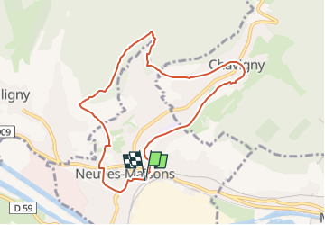
18,3 km | 23 km-effort
4h 15min
![](https://static1.geolcdn.com/siteimages/upload/files/16400158638029165_repeat_loop_refresh_sync_direction_icon.png)
Sí
![Excursión sport Ludres - Ludres - Photo](https://media.geolcdn.com/t/375/260/4a41c09b-4979-47d6-9e86-ddd52f153625.jpg&format=jpg&maxdim=2)
Ludres
sport
Muy fácil
Ludres,
Gran Este,
Meurthe y Mosela,
France
![](/images/other/stat-length.png)
11,6 km | 14,9 km-effort
Desconocido
![](https://static1.geolcdn.com/siteimages/upload/files/16400158638029165_repeat_loop_refresh_sync_direction_icon.png)
Sí
![Excursión Senderismo Ludres - SityTrail - Marche gourmande 11km - Photo](https://media.geolcdn.com/t/375/260/ext.jpg?maxdim=2&url=https%3A%2F%2Fstatic1.geolcdn.com%2Fsiteimages%2Fupload%2Ffiles%2F1553511878bg_sport_marche.png)
![Senderismo Senderismo](https://static1.geolcdn.com/sitytour/trail-icons/101.png)
SityTrail - Marche gourmande 11km
Senderismo
Difícil
(2)
Ludres,
Gran Este,
Meurthe y Mosela,
France
![](/images/other/stat-length.png)
10,4 km | 12,1 km-effort
2h 45min
![](https://static1.geolcdn.com/siteimages/upload/files/16400158638029165_repeat_loop_refresh_sync_direction_icon.png)
Sí
![Excursión Senderismo Ludres - marche nuit - Photo](https://media.geolcdn.com/t/375/260/2c15af7e-0536-4068-be2b-216477912337.jpg&format=jpg&maxdim=2)
![Senderismo Senderismo](https://static1.geolcdn.com/sitytour/trail-icons/101.png)
marche nuit
Senderismo
Medio
Ludres,
Gran Este,
Meurthe y Mosela,
France
![](/images/other/stat-length.png)
8,7 km | 10,1 km-effort
2h 11min
![](https://static1.geolcdn.com/siteimages/upload/files/16400158638029165_repeat_loop_refresh_sync_direction_icon.png)
Sí
![Excursión Senderismo Villers-lès-Nancy - RANDO DUO AVEC ALEXIS - Photo](https://media.geolcdn.com/t/375/260/ext.jpg?maxdim=2&url=https%3A%2F%2Fstatic1.geolcdn.com%2Fsiteimages%2Fupload%2Ffiles%2F1553511878bg_sport_marche.png)
![Senderismo Senderismo](https://static1.geolcdn.com/sitytour/trail-icons/101.png)
RANDO DUO AVEC ALEXIS
Senderismo
Difícil
(1)
Villers-lès-Nancy,
Gran Este,
Meurthe y Mosela,
France
![](/images/other/stat-length.png)
38 km | 45 km-effort
10h 19min
![](https://static1.geolcdn.com/siteimages/upload/files/16400158638029165_repeat_loop_refresh_sync_direction_icon.png)
No
![Excursión Marcha nórdica Ludres - Randonnée Ludres la mine la maison Patrick et Nini - Photo](https://media.geolcdn.com/t/375/260/2aa95365-fabd-4569-b6c7-48b029e99a55.jpg&format=jpg&maxdim=2)
![Marcha nórdica Marcha nórdica](https://static1.geolcdn.com/sitytour/trail-icons/102.png)
Randonnée Ludres la mine la maison Patrick et Nini
Marcha nórdica
Fácil
Ludres,
Gran Este,
Meurthe y Mosela,
France
![](/images/other/stat-length.png)
6,7 km | 8,4 km-effort
1h 48min
![](https://static1.geolcdn.com/siteimages/upload/files/16400158638029165_repeat_loop_refresh_sync_direction_icon.png)
No
![Excursión Marcha nórdica Ludres - Randonnée Ludres Belvédère - Photo](https://media.geolcdn.com/t/375/260/e4a847d5-4f8b-43b2-8f0d-49e66642522d.jpg&format=jpg&maxdim=2)
![Marcha nórdica Marcha nórdica](https://static1.geolcdn.com/sitytour/trail-icons/102.png)
Randonnée Ludres Belvédère
Marcha nórdica
Fácil
Ludres,
Gran Este,
Meurthe y Mosela,
France
![](/images/other/stat-length.png)
6,7 km | 8 km-effort
1h 44min
![](https://static1.geolcdn.com/siteimages/upload/files/16400158638029165_repeat_loop_refresh_sync_direction_icon.png)
Sí
![Excursión Senderismo Bainville-sur-Madon - BAINVILLE SUR MADON - CIRCUIT VOIVRE ET JACQUES CALLOT - Photo](https://media.geolcdn.com/t/375/260/71b1e74d-91cb-4458-89e0-3ec0ae2fe5ca.jpg&format=jpg&maxdim=2)
![Senderismo Senderismo](https://static1.geolcdn.com/sitytour/trail-icons/101.png)
BAINVILLE SUR MADON - CIRCUIT VOIVRE ET JACQUES CALLOT
Senderismo
Medio
Bainville-sur-Madon,
Gran Este,
Meurthe y Mosela,
France
![](/images/other/stat-length.png)
19,8 km | 24 km-effort
5h 44min
![](https://static1.geolcdn.com/siteimages/upload/files/16400158638029165_repeat_loop_refresh_sync_direction_icon.png)
Sí
![Excursión Senderismo Vandœuvre-lès-Nancy - Ludres 12 500m +178m - Photo](https://media.geolcdn.com/t/375/260/ext.jpg?maxdim=2&url=https%3A%2F%2Fservices.sitytrail.com%2FGeolivesWS%2FDownloadMedia.ashx%3FTrailID%3D796591%26Media%3Dfix__20170726160233.jpg)
![Senderismo Senderismo](https://static1.geolcdn.com/sitytour/trail-icons/101.png)
Ludres 12 500m +178m
Senderismo
Muy fácil
Vandœuvre-lès-Nancy,
Gran Este,
Meurthe y Mosela,
France
![](/images/other/stat-length.png)
12,3 km | 14,5 km-effort
3h 14min
![](https://static1.geolcdn.com/siteimages/upload/files/16400158638029165_repeat_loop_refresh_sync_direction_icon.png)
Sí