![](/images/other/stat-length.png)
![Excursión Senderismo Saint-Agnan-en-Vercors - 2024-03-05_14h21m24_erges-tiolache-serre-brion (1) - Photo](https://media.geolcdn.com/t/1900/400/ext.pjpeg?maxdim=2&url=https%3A%2F%2Fstatic1.geolcdn.com%2Fsiteimages%2Fupload%2Ffiles%2F1553511878bg_sport_marche.png)
2024-03-05_14h21m24_erges-tiolache-serre-brion (1)
okfred26
Usuario
![Longitud](/images/other/stat-length.png)
![Altitud máxima](https://static1.geolcdn.com/siteimages/upload/files/1508320355ic_sort_altitude_max_24dp.png)
![Desnivel positivo](https://static1.geolcdn.com/siteimages/upload/files/1508320355ic_sort_den_pos_24dp.png)
![Km-Effort](/images/other/stat-length.png)
![Altitud mínima](https://static1.geolcdn.com/siteimages/upload/files/1508320355ic_sort_altitude_min_24dp.png)
![Desnivel negativo](https://static1.geolcdn.com/siteimages/upload/files/1508320355ic_sort_den_neg_24dp.png)
![Boucle](https://static1.geolcdn.com/siteimages/upload/files/16400158638029165_repeat_loop_refresh_sync_direction_icon.png)
![Senderismo](https://static1.geolcdn.com/sitytour/trail-icons/101.png)
5h26
Dificultad : Muy difícil
![Escanee este código QR para abrir la excursión en la aplicación SityTrail](https://capi.geolives.com/qq0zvz2zws4bq2lad0pu/sitytour/trails/3970752/qr.png?size=200)
Aplicación GPS de excursión GRATIS
A propósito
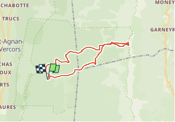
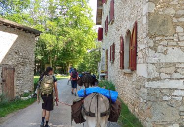
Ruta Senderismo de 14,2 km a descubrir en Auvergne-Rhône-Alpes, Drôme, Saint-Agnan-en-Vercors. Esta ruta ha sido propuesta por okfred26.
Descripción
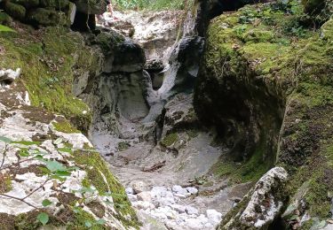
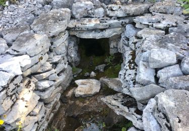
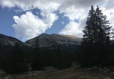
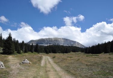
[b]Description[/b] : En partant de la barrière de la route forestière des [b]Bachassons[/b], rejoindre le [b]Pas de Serre Brion[/b], permet d'abord de suivre un cheminement aventureux à travers [b]Tiolache[/b], au Sud de la [b]Forêt du Play[/b]. Ensuite, depuis [b]Tiolache-Haut[/b], l'ascension permet de visiter une combe sauvage au pied des [b]Rochers du Ranc Traversier[/b] avant de traverser vers le [b]Pas de Serre Brion[/b]. La descente emprunte une sente déjà repérée, qui pourrait être le vestige du vieux chemin du pas à travers le versant Ouest. De retour à [b]Tiolache-Haut[/b], c'est un parcours agréable à travers de larges vallons herbeux qui conduit au [b]Sentier Central[/b] par la [b]Fontaine de Tiolache[/b], et par là au point de départ.
[b]Description complète[/b] et photos sur sentier-nature.com : [url=http://www.sentier-nature.com/montagne/2011/06/28/347-erges-tiolache-serre-brion]Hors sentier au Pas de Serre Brion, versant Ouest[/url].
[b]Avertissement[/b] : Certains passages de cet itinéraire de montagne sont escarpés et/ou exposés, il est déconseillé aux enfants non accompagnés et aux personnes sujettes au vertige. Pour votre sécurité, nous vous invitons à respecter les règles suivantes : être bien chaussé, ne pas s'engager par mauvais temps, ne pas s'écarter de l'itinéraire ni des sentiers.
Cet itinéraire ce déroule tout ou partie dans la Réserve Naturelle des Hauts Plateaux du Vercors qui a pour mission d'étudier et de gérer ce territoire afin que les diverses activités qui s'y exercent (élevage, exploitation forestière, randonnée, etc.) soient compatibles avec la préservation de la faune, de la flore et du paysage. Participez à la protection de cet espace en respectant la réglementation.
Localización
Comentarios
Excursiones cerca
![Excursión Senderismo Saint-Agnan-en-Vercors - Vercors - La Coche Grand Veymont Queyrie - Photo](https://media.geolcdn.com/t/375/260/ext.jpg?maxdim=2&url=https%3A%2F%2Fstatic1.geolcdn.com%2Fsiteimages%2Fupload%2Ffiles%2F1553511878bg_sport_marche.png)
![Senderismo Senderismo](https://static1.geolcdn.com/sitytour/trail-icons/101.png)
Senderismo
![](/images/other/stat-length.png)
![](https://static1.geolcdn.com/siteimages/upload/files/16400158638029165_repeat_loop_refresh_sync_direction_icon.png)
![Excursión Senderismo Saint-Agnan-en-Vercors - 26 tiolache - Photo](https://media.geolcdn.com/t/375/260/901b344f-b319-4266-9f0a-69075395b314.jpg&format=jpg&maxdim=2)
![Senderismo Senderismo](https://static1.geolcdn.com/sitytour/trail-icons/101.png)
Senderismo
![](/images/other/stat-length.png)
![](https://static1.geolcdn.com/siteimages/upload/files/16400158638029165_repeat_loop_refresh_sync_direction_icon.png)
![Excursión Senderismo Saint-Agnan-en-Vercors - 26 st Agnan champ gros de la vache - Photo](https://media.geolcdn.com/t/375/260/3e876886-71b3-45d3-bba1-ada65af3bf18.jpg&format=jpg&maxdim=2)
![Senderismo Senderismo](https://static1.geolcdn.com/sitytour/trail-icons/101.png)
Senderismo
![](/images/other/stat-length.png)
![](https://static1.geolcdn.com/siteimages/upload/files/16400158638029165_repeat_loop_refresh_sync_direction_icon.png)
![Excursión Senderismo Saint-Agnan-en-Vercors - trop Alexis - Photo](https://media.geolcdn.com/t/375/260/c36b90eb-63fa-4a9c-9518-bbd91f5e8a29.jpg&format=jpg&maxdim=2)
![Senderismo Senderismo](https://static1.geolcdn.com/sitytour/trail-icons/101.png)
Senderismo
![](/images/other/stat-length.png)
![](https://static1.geolcdn.com/siteimages/upload/files/16400158638029165_repeat_loop_refresh_sync_direction_icon.png)
![Excursión Senderismo Saint-Agnan-en-Vercors - Malaval - Photo](https://media.geolcdn.com/t/375/260/39c0c415-627d-42e7-b9a5-65769dc8255c.jpg&format=jpg&maxdim=2)
![Senderismo Senderismo](https://static1.geolcdn.com/sitytour/trail-icons/101.png)
Senderismo
![](/images/other/stat-length.png)
![](https://static1.geolcdn.com/siteimages/upload/files/16400158638029165_repeat_loop_refresh_sync_direction_icon.png)
![Excursión Senderismo Vassieux-en-Vercors - Vassieux en Vercors- La Chapelle en Vercors- Rando Âne (2 et 3 ème jour) - - Photo](https://media.geolcdn.com/t/375/260/b814f45e-86a3-40dc-a4db-45926f9b0da2.jpg&format=jpg&maxdim=2)
![Senderismo Senderismo](https://static1.geolcdn.com/sitytour/trail-icons/101.png)
Senderismo
![](/images/other/stat-length.png)
![](https://static1.geolcdn.com/siteimages/upload/files/16400158638029165_repeat_loop_refresh_sync_direction_icon.png)
![Excursión Senderismo La Chapelle-en-Vercors - La Chapelle en Vercors - Vassieux (Première étape balade ânes) - Photo](https://media.geolcdn.com/t/375/260/b49bd35a-4f2e-4f1b-8661-fc564460d7b5.jpg&format=jpg&maxdim=2)
![Senderismo Senderismo](https://static1.geolcdn.com/sitytour/trail-icons/101.png)
Senderismo
![](/images/other/stat-length.png)
![](https://static1.geolcdn.com/siteimages/upload/files/16400158638029165_repeat_loop_refresh_sync_direction_icon.png)
![Excursión Senderismo Saint-Agnan-en-Vercors - Grand Veymont par pré râteau - Photo](https://media.geolcdn.com/t/375/260/e54a027e-72ab-4658-aa09-80fa6ce42b41.jpg&format=jpg&maxdim=2)
![Senderismo Senderismo](https://static1.geolcdn.com/sitytour/trail-icons/101.png)
Senderismo
![](/images/other/stat-length.png)
![](https://static1.geolcdn.com/siteimages/upload/files/16400158638029165_repeat_loop_refresh_sync_direction_icon.png)
![Senderismo Senderismo](https://static1.geolcdn.com/sitytour/trail-icons/101.png)
Senderismo
![](/images/other/stat-length.png)
![](https://static1.geolcdn.com/siteimages/upload/files/16400158638029165_repeat_loop_refresh_sync_direction_icon.png)