![](/images/other/stat-length.png)
![Excursión Senderismo Stoumont - chevron Promenade des fontaines - Photo](https://media.geolcdn.com/t/1900/400/72275c78-3eec-41a4-a6e4-3006a406ab26.jpg&format=pjpeg&maxdim=2)
chevron Promenade des fontaines
evelynevd
Usuario
![Longitud](/images/other/stat-length.png)
![Altitud máxima](https://static1.geolcdn.com/siteimages/upload/files/1508320355ic_sort_altitude_max_24dp.png)
![Desnivel positivo](https://static1.geolcdn.com/siteimages/upload/files/1508320355ic_sort_den_pos_24dp.png)
![Km-Effort](/images/other/stat-length.png)
![Altitud mínima](https://static1.geolcdn.com/siteimages/upload/files/1508320355ic_sort_altitude_min_24dp.png)
![Desnivel negativo](https://static1.geolcdn.com/siteimages/upload/files/1508320355ic_sort_den_neg_24dp.png)
![Boucle](https://static1.geolcdn.com/siteimages/upload/files/16400158638029165_repeat_loop_refresh_sync_direction_icon.png)
![Senderismo](https://static1.geolcdn.com/sitytour/trail-icons/101.png)
2h27
Dificultad : Medio
![Escanee este código QR para abrir la excursión en la aplicación SityTrail](https://capi.geolives.com/qq0zvz2zws4bq2lad0pu/sitytour/trails/3968579/qr.png?size=200)
Aplicación GPS de excursión GRATIS
A propósito
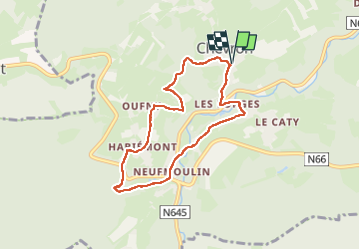
Ruta Senderismo de 6,4 km a descubrir en Valonia, Lieja, Stoumont. Esta ruta ha sido propuesta por evelynevd.
Descripción
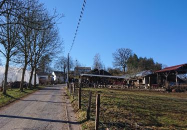
Chevron est une section de la commune belge de Stoumont située en Région wallonne dans la province de Liège.
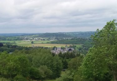
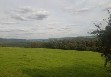
Situé à 350 mètres d'altitude dans un paysage accidenté et verdoyant, Chevron domine la vallée de la Lienne, autrefois connue pour ses roches, ses fonderies et ses mines de manganèse. L'essentiel de sa superficie est occupé par des prairies et de vastes forêts où les résineux dominent
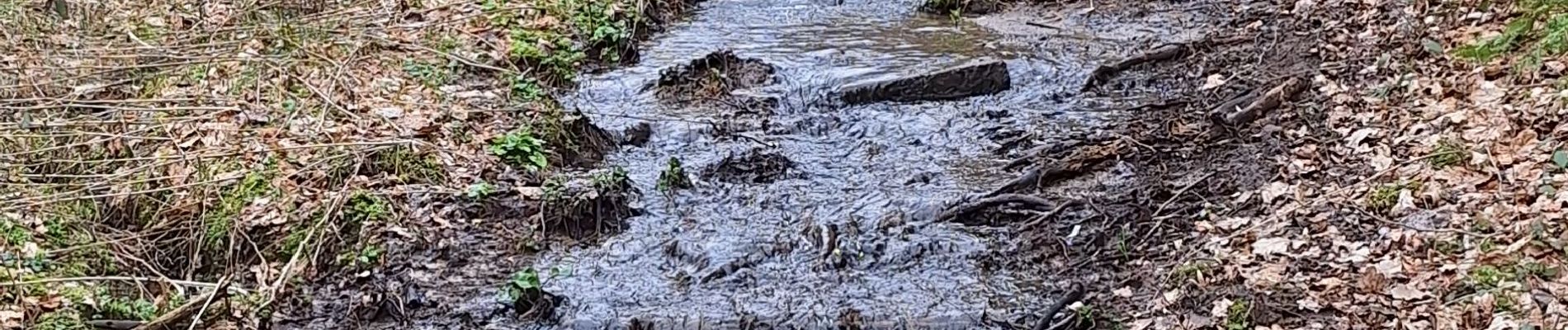
La promenade des fontaines est très varié, entre forêt, pâtures, chemins creux et rivières. Tantôt sous le couvert, tantôt dominant la vallée de la Lienne, avecdes panoramas grandioses qui dominent la vallée de la Lienne. Sur certains passages on suit la Lienne qui s écoule doucement avec un joli bruit de ruissellement
Cet itinéraire suit les fontaines que possédaient tous les hameaux de l’ancienne entité de Chevron. Ces fontaines fournissaient l’eau potable dont les villageois avaient besoin. Elles étaient prolongées par un bac destiné à la lesssive et les fermiers venaient y puiser l’eau pour leur bétail. C’était également un lieu de rencontre et de convivialité.
A certains endroits vous trouverez bancs et table afin de pouvoir vous restaurez ( si vous avez amené votre pic-nic avec vous) ou vous reposez.
Cette balade est vraiment très bien balisée (rectangle bleu ST01)
Difficulté Moyen
Localización
Comentarios
Excursiones cerca
![Excursión Senderismo Stoumont - Lorcé, Natura 2000 - Des sites qui valent le détour, Lg13 - Photo](https://media.geolcdn.com/t/375/260/ext.jpg?maxdim=2&url=https%3A%2F%2Fservices.sitytrail.com%2FGeolivesWS%2FDownloadMedia.ashx%3FTrailID%3D182859%26Media%3D43b80b1e-327b-4d3e-accc-f8b9c8a445c2.JPG)
![Senderismo Senderismo](https://static1.geolcdn.com/sitytour/trail-icons/101.png)
Senderismo
![](/images/other/stat-length.png)
![](https://static1.geolcdn.com/siteimages/upload/files/16400158638029165_repeat_loop_refresh_sync_direction_icon.png)
![Excursión Senderismo Stoumont - RB-Lg-14 - Raccourci - Photo](https://media.geolcdn.com/t/375/260/ext.jpg?maxdim=2&url=https%3A%2F%2Fservices.sitytrail.com%2FGeolivesWS%2FDownloadMedia.ashx%3FTrailID%3D179572%26Media%3Ddd649bf1-a115-4c1e-9e23-c1a80ab51103.jpg)
![Senderismo Senderismo](https://static1.geolcdn.com/sitytour/trail-icons/101.png)
Senderismo
![](/images/other/stat-length.png)
![](https://static1.geolcdn.com/siteimages/upload/files/16400158638029165_repeat_loop_refresh_sync_direction_icon.png)
![Excursión Senderismo Stoumont - 2022-02-03_17h52m52_StoumontP14PromenadedessommetsdelaLienne - Photo](https://media.geolcdn.com/t/375/260/a2987c7f-4dfa-4904-87e7-be0c835ea8dd.jpg&format=jpg&maxdim=2)
![Senderismo Senderismo](https://static1.geolcdn.com/sitytour/trail-icons/101.png)
Senderismo
![](/images/other/stat-length.png)
![](https://static1.geolcdn.com/siteimages/upload/files/16400158638029165_repeat_loop_refresh_sync_direction_icon.png)
![Excursión Senderismo Stoumont - lorcé . suf la lienne . Chevron . lorcé - Photo](https://media.geolcdn.com/t/375/260/9599f201-d2ad-4521-ad0a-b4661e5a5ff4.jpg&format=jpg&maxdim=2)
![Senderismo Senderismo](https://static1.geolcdn.com/sitytour/trail-icons/101.png)
Senderismo
![](/images/other/stat-length.png)
![](https://static1.geolcdn.com/siteimages/upload/files/16400158638029165_repeat_loop_refresh_sync_direction_icon.png)
![Excursión Senderismo Aywaille - houssonloge . bois du pouhon . trou de bosson . paradis . houssonloge - Photo](https://media.geolcdn.com/t/375/260/8bc033a3-d4f5-4c9f-9bb4-a2d3fb614b59.jpg&format=jpg&maxdim=2)
![Senderismo Senderismo](https://static1.geolcdn.com/sitytour/trail-icons/101.png)
Senderismo
![](/images/other/stat-length.png)
![](https://static1.geolcdn.com/siteimages/upload/files/16400158638029165_repeat_loop_refresh_sync_direction_icon.png)
![Excursión Senderismo Stoumont - RB-Lg-14 - De point de vue en point de vue autour de Lorcé - Photo](https://media.geolcdn.com/t/375/260/ext.jpg?maxdim=2&url=https%3A%2F%2Fservices.sitytrail.com%2FGeolivesWS%2FDownloadMedia.ashx%3FTrailID%3D179572%26Media%3Ddd649bf1-a115-4c1e-9e23-c1a80ab51103.jpg)
![Senderismo Senderismo](https://static1.geolcdn.com/sitytour/trail-icons/101.png)
Senderismo
![](/images/other/stat-length.png)
![](https://static1.geolcdn.com/siteimages/upload/files/16400158638029165_repeat_loop_refresh_sync_direction_icon.png)
![Excursión Senderismo Stoumont - 10km sous la pluie autour de Lorcé - Photo](https://media.geolcdn.com/t/375/260/cbc0016a-dfca-4c73-9974-c42c5bf54007.jpg&format=jpg&maxdim=2)
![Senderismo Senderismo](https://static1.geolcdn.com/sitytour/trail-icons/101.png)
Senderismo
![](/images/other/stat-length.png)
![](https://static1.geolcdn.com/siteimages/upload/files/16400158638029165_repeat_loop_refresh_sync_direction_icon.png)
![Excursión Senderismo Stoumont - ST12 Lorcé . Chession . Lorcé - Photo](https://media.geolcdn.com/t/375/260/4fb5fd46-a2f8-4332-bf19-91c606197682.jpg&format=jpg&maxdim=2)
![Senderismo Senderismo](https://static1.geolcdn.com/sitytour/trail-icons/101.png)
Senderismo
![](/images/other/stat-length.png)
![](https://static1.geolcdn.com/siteimages/upload/files/16400158638029165_repeat_loop_refresh_sync_direction_icon.png)
![Excursión Senderismo Stoumont - Tour Lorcé Chevron - Photo](https://media.geolcdn.com/t/375/260/6a4a07e0-645e-4567-8da1-cb8239aaf8df.jpg&format=jpg&maxdim=2)
![Senderismo Senderismo](https://static1.geolcdn.com/sitytour/trail-icons/101.png)
Senderismo
![](/images/other/stat-length.png)
![](https://static1.geolcdn.com/siteimages/upload/files/16400158638029165_repeat_loop_refresh_sync_direction_icon.png)