![](/images/other/stat-length.png)
![Excursión Senderismo Mazaugues - De Mazaugues vers la glacière Pivaut - Photo](https://media.geolcdn.com/t/1900/400/93cdb635-dd33-4fbf-b53a-783eebba00a2.jpg&format=pjpeg&maxdim=2)
De Mazaugues vers la glacière Pivaut
FSantoni
Usuario
![Longitud](/images/other/stat-length.png)
![Altitud máxima](https://static1.geolcdn.com/siteimages/upload/files/1508320355ic_sort_altitude_max_24dp.png)
![Desnivel positivo](https://static1.geolcdn.com/siteimages/upload/files/1508320355ic_sort_den_pos_24dp.png)
![Km-Effort](/images/other/stat-length.png)
![Altitud mínima](https://static1.geolcdn.com/siteimages/upload/files/1508320355ic_sort_altitude_min_24dp.png)
![Desnivel negativo](https://static1.geolcdn.com/siteimages/upload/files/1508320355ic_sort_den_neg_24dp.png)
![Boucle](https://static1.geolcdn.com/siteimages/upload/files/16400158638029165_repeat_loop_refresh_sync_direction_icon.png)
![Senderismo](https://static1.geolcdn.com/sitytour/trail-icons/101.png)
7h01
Dificultad : Muy difícil
![Escanee este código QR para abrir la excursión en la aplicación SityTrail](https://capi.geolives.com/qq0zvz2zws4bq2lad0pu/sitytour/trails/3967740/qr.png?size=200)
Aplicación GPS de excursión GRATIS
A propósito
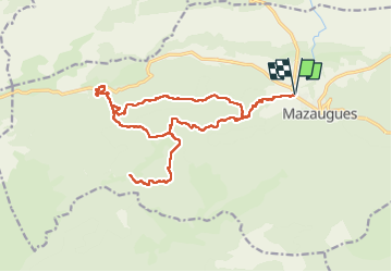
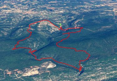
Ruta Senderismo de 22 km a descubrir en Provenza-Alpes-Costa Azul, Var, Mazaugues. Esta ruta ha sido propuesta por FSantoni.
Descripción
Beaucoup de pistes (pas forcément ce que je préfère) sur une bonne partie de cette rando.
En notant que le bout d'aller-retour en bas du plan est à éviter car il ne débouche sur rien d’intéressant, en tout cas pour aller vers la glacière Pivaut, qui était le but de notre balade.
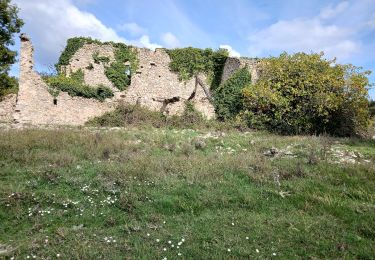
Il reste cependant de beaux paysages, une belle vue vers le mourre d'Agnis, des houx magnifiques et une visite instructive de la glacière Pivaut, en excellent état de restauration.
Localización
Comentarios
Excursiones cerca
![Excursión Senderismo Mazaugues - Mazaugues 21.4.24 - Photo](https://media.geolcdn.com/t/375/260/73ef7019-56c4-45d7-90ef-e1bea2022610.jpg&format=jpg&maxdim=2)
![Senderismo Senderismo](https://static1.geolcdn.com/sitytour/trail-icons/101.png)
Senderismo
![](/images/other/stat-length.png)
![](https://static1.geolcdn.com/siteimages/upload/files/16400158638029165_repeat_loop_refresh_sync_direction_icon.png)
![Excursión Senderismo Tourves - SityTrail - Tourves- Le Saut du Cabri - Les gorges du Caramy - Photo](https://media.geolcdn.com/t/375/260/124cbbf2-932c-4737-ad3d-4f1fc25db1d8.jpg&format=jpg&maxdim=2)
![Senderismo Senderismo](https://static1.geolcdn.com/sitytour/trail-icons/101.png)
Senderismo
![](/images/other/stat-length.png)
![](https://static1.geolcdn.com/siteimages/upload/files/16400158638029165_repeat_loop_refresh_sync_direction_icon.png)
![Excursión Senderismo Mazaugues - le Mourre d'Agnis au départ du Caucadis - Photo](https://media.geolcdn.com/t/375/260/dcd1794e-c5af-44e1-af91-1fadcb296c68.jpg&format=jpg&maxdim=2)
![Senderismo Senderismo](https://static1.geolcdn.com/sitytour/trail-icons/101.png)
Senderismo
![](/images/other/stat-length.png)
![](https://static1.geolcdn.com/siteimages/upload/files/16400158638029165_repeat_loop_refresh_sync_direction_icon.png)
![Excursión Senderismo Mazaugues - Mazaugues le vallon de l'Herbette - Photo](https://media.geolcdn.com/t/375/260/62c4707c-a050-47d0-822e-64a046e156e1.jpg&format=jpg&maxdim=2)
![Senderismo Senderismo](https://static1.geolcdn.com/sitytour/trail-icons/101.png)
Senderismo
![](/images/other/stat-length.png)
![](https://static1.geolcdn.com/siteimages/upload/files/16400158638029165_repeat_loop_refresh_sync_direction_icon.png)
![Excursión Senderismo La Roquebrussanne - la montagne de la Loube - Photo](https://media.geolcdn.com/t/375/260/ba5f3ad3-4eed-4285-a8f8-9cedf60e39f2.jpg&format=jpg&maxdim=2)
![Senderismo Senderismo](https://static1.geolcdn.com/sitytour/trail-icons/101.png)
Senderismo
![](/images/other/stat-length.png)
![](https://static1.geolcdn.com/siteimages/upload/files/16400158638029165_repeat_loop_refresh_sync_direction_icon.png)
![Excursión Senderismo Tourves - chapelle Saint Probace et gorges du caramy - Photo](https://media.geolcdn.com/t/375/260/ext.jpg?maxdim=2&url=https%3A%2F%2Fservices.sitytrail.com%2FGeolivesWS%2FDownloadMedia.ashx%3FTrailID%3D984279%26Media%3Dfix__20180610150603.jpg)
![Senderismo Senderismo](https://static1.geolcdn.com/sitytour/trail-icons/101.png)
Senderismo
![](/images/other/stat-length.png)
![](https://static1.geolcdn.com/siteimages/upload/files/16400158638029165_repeat_loop_refresh_sync_direction_icon.png)
![Senderismo Senderismo](https://static1.geolcdn.com/sitytour/trail-icons/101.png)
Senderismo
![](/images/other/stat-length.png)
![](https://static1.geolcdn.com/siteimages/upload/files/16400158638029165_repeat_loop_refresh_sync_direction_icon.png)
![Excursión A pie Mazaugues - Mazaugues-Mourre d'Agnis-23-10-2024 - Photo](https://media.geolcdn.com/t/375/260/8bdd9a43-13c3-4a0a-a9d2-ae092f24102a.jpg&format=jpg&maxdim=2)
![A pie A pie](https://static1.geolcdn.com/sitytour/trail-icons/100.png)
A pie
![](/images/other/stat-length.png)
![](https://static1.geolcdn.com/siteimages/upload/files/16400158638029165_repeat_loop_refresh_sync_direction_icon.png)
![Excursión Senderismo Tourves - Caramy version courte - Photo](https://media.geolcdn.com/t/375/260/37415954-4374-47c8-b9b8-5d268df2d30c.jpg&format=jpg&maxdim=2)
![Senderismo Senderismo](https://static1.geolcdn.com/sitytour/trail-icons/101.png)
Senderismo
![](/images/other/stat-length.png)
![](https://static1.geolcdn.com/siteimages/upload/files/16400158638029165_repeat_loop_refresh_sync_direction_icon.png)