![](/images/other/stat-length.png)
![Excursión Raquetas de nieve Auvare - Col de Sui - Photo](https://media.geolcdn.com/t/1900/400/6bc42f12-7cff-4b73-b3a2-842962fcc359.jpg&format=pjpeg&maxdim=2)
Col de Sui
bozo1970
Usuario
![Longitud](/images/other/stat-length.png)
![Altitud máxima](https://static1.geolcdn.com/siteimages/upload/files/1508320355ic_sort_altitude_max_24dp.png)
![Desnivel positivo](https://static1.geolcdn.com/siteimages/upload/files/1508320355ic_sort_den_pos_24dp.png)
![Km-Effort](/images/other/stat-length.png)
![Altitud mínima](https://static1.geolcdn.com/siteimages/upload/files/1508320355ic_sort_altitude_min_24dp.png)
![Desnivel negativo](https://static1.geolcdn.com/siteimages/upload/files/1508320355ic_sort_den_neg_24dp.png)
![Boucle](https://static1.geolcdn.com/siteimages/upload/files/16400158638029165_repeat_loop_refresh_sync_direction_icon.png)
![Raquetas de nieve](https://static1.geolcdn.com/sitytour/trail-icons/504.png)
4h56
Dificultad : Difícil
![Escanee este código QR para abrir la excursión en la aplicación SityTrail](https://capi.geolives.com/qq0zvz2zws4bq2lad0pu/sitytour/trails/3965716/qr.png?size=200)
Aplicación GPS de excursión GRATIS
A propósito
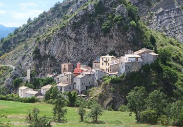
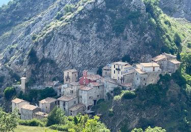
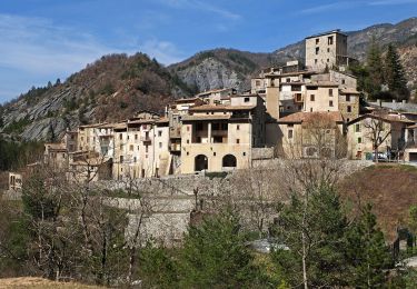
Ruta Raquetas de nieve de 13,7 km a descubrir en Provenza-Alpes-Costa Azul, Alpes Marítimos, Auvare. Esta ruta ha sido propuesta por bozo1970.
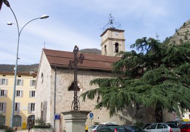
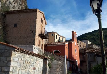
Descripción
Départ d’Auvare
Col du Mont en 30’ D 210 et 1km600
Baisse de Fleirel en 54’ D 330 et 2km600
Col de Pras en 1h23’ D 529 et 3km700
Col de Vigude en 2h18’ D 767 et 6km350
Balise 254 en 2h58 D 934 et 7km500
A/R en 5h D 995er 14km
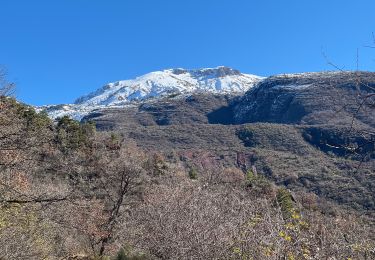
40cm de neige tombée la veille, très collante
Impossible d’atteindre le Dôme de Barrot, trop loin, dommage !
Aucun animal
Localización
Comentarios
Excursiones cerca
![Excursión A pie La Croix-sur-Roudoule - Tour du Mont d'Auvare - Photo](https://media.geolcdn.com/t/375/260/996cc198-4e38-4ec8-91f6-2dc8bedea61a.jpeg&format=jpg&maxdim=2)
![A pie A pie](https://static1.geolcdn.com/sitytour/trail-icons/100.png)
A pie
![](/images/other/stat-length.png)
![](https://static1.geolcdn.com/siteimages/upload/files/16400158638029165_repeat_loop_refresh_sync_direction_icon.png)
![Excursión A pie Puget-Théniers - Circuit des Aubrics - Photo](https://media.geolcdn.com/t/375/260/eb7c8b5b-77ab-46d8-b27b-8aa2a4d5707f.jpeg&format=jpg&maxdim=2)
![A pie A pie](https://static1.geolcdn.com/sitytour/trail-icons/100.png)
A pie
![](/images/other/stat-length.png)
![](https://static1.geolcdn.com/siteimages/upload/files/16400158638029165_repeat_loop_refresh_sync_direction_icon.png)
![Excursión Senderismo Puget-Théniers - Puget théniers-Entrevaux par le col de Vélacs - Photo](https://media.geolcdn.com/t/375/260/ext.jpg?maxdim=2&url=https%3A%2F%2Fstatic1.geolcdn.com%2Fsiteimages%2Fupload%2Ffiles%2F1553511878bg_sport_marche.png)
![Senderismo Senderismo](https://static1.geolcdn.com/sitytour/trail-icons/101.png)
Senderismo
![](/images/other/stat-length.png)
![](https://static1.geolcdn.com/siteimages/upload/files/16400158638029165_repeat_loop_refresh_sync_direction_icon.png)
![Excursión Raquetas de nieve La Croix-sur-Roudoule - Haute Mihubi - Photo](https://media.geolcdn.com/t/375/260/1d4f53a5-26a7-401e-8036-fe63dce3123b.jpg&format=jpg&maxdim=2)
![Raquetas de nieve Raquetas de nieve](https://static1.geolcdn.com/sitytour/trail-icons/504.png)
Raquetas de nieve
![](/images/other/stat-length.png)
![](https://static1.geolcdn.com/siteimages/upload/files/16400158638029165_repeat_loop_refresh_sync_direction_icon.png)
![Excursión Senderismo Auvare - Auvare Dôme de Barrot - Photo](https://media.geolcdn.com/t/375/260/6ceb6f88-7fe0-4b85-8e5d-3edc54cb29ea.jpg&format=jpg&maxdim=2)
![Senderismo Senderismo](https://static1.geolcdn.com/sitytour/trail-icons/101.png)
Senderismo
![](/images/other/stat-length.png)
![](https://static1.geolcdn.com/siteimages/upload/files/16400158638029165_repeat_loop_refresh_sync_direction_icon.png)
![Excursión Senderismo Auvare - Auvare : le dôme de Barrot - Photo](https://media.geolcdn.com/t/375/260/b2f42d03-2761-4b24-bd6b-940146a080a2.jpg&format=jpg&maxdim=2)
![Senderismo Senderismo](https://static1.geolcdn.com/sitytour/trail-icons/101.png)
Senderismo
![](/images/other/stat-length.png)
![](https://static1.geolcdn.com/siteimages/upload/files/16400158638029165_repeat_loop_refresh_sync_direction_icon.png)
![Excursión A pie Puget-Rostang - Circuit de Mairola - Photo](https://media.geolcdn.com/t/375/260/1c86b0fc-009b-4c3f-8a58-55925a6af374.jpeg&format=jpg&maxdim=2)
![A pie A pie](https://static1.geolcdn.com/sitytour/trail-icons/100.png)
A pie
![](/images/other/stat-length.png)
![](https://static1.geolcdn.com/siteimages/upload/files/16400158638029165_repeat_loop_refresh_sync_direction_icon.png)
![Excursión Senderismo La Croix-sur-Roudoule - tête de pibossans par col de la roua . - Photo](https://media.geolcdn.com/t/375/260/be9e76bd-208b-4adc-aae2-dc7ac2d9ee83.jpg&format=jpg&maxdim=2)
![Senderismo Senderismo](https://static1.geolcdn.com/sitytour/trail-icons/101.png)
Senderismo
![](/images/other/stat-length.png)
![](https://static1.geolcdn.com/siteimages/upload/files/16400158638029165_repeat_loop_refresh_sync_direction_icon.png)
![Excursión Senderismo Puget-Théniers - Puget-Théniers - 2016 06 15 - Photo](https://media.geolcdn.com/t/375/260/ext.jpg?maxdim=2&url=https%3A%2F%2Fservices.sitytrail.com%2FGeolivesWS%2FDownloadMedia.ashx%3FTrailID%3D597793%26Media%3Dfix__20160615132255.jpg)
![Senderismo Senderismo](https://static1.geolcdn.com/sitytour/trail-icons/101.png)
Senderismo
![](/images/other/stat-length.png)
![](https://static1.geolcdn.com/siteimages/upload/files/16400158638029165_repeat_loop_refresh_sync_direction_icon.png)