![](/images/other/stat-length.png)
![Excursión A pie Oderen - Rando CLAS 29 /02/2024 .Chapelle St NICOLAS .17 km D+/- 820 m - Photo](https://media.geolcdn.com/t/1900/400/ext.pjpeg?maxdim=2&url=https%3A%2F%2Fstatic1.geolcdn.com%2Fsiteimages%2Fupload%2Ffiles%2F1545311037marcheuse_200dpi.jpg)
Rando CLAS 29 /02/2024 .Chapelle St NICOLAS .17 km D+/- 820 m
boubou68
Usuario
![Longitud](/images/other/stat-length.png)
Longitud
16,6 km
![Altitud máxima](https://static1.geolcdn.com/siteimages/upload/files/1508320355ic_sort_altitude_max_24dp.png)
Altitud máxima
1221 m
![Desnivel positivo](https://static1.geolcdn.com/siteimages/upload/files/1508320355ic_sort_den_pos_24dp.png)
Desnivel positivo
822 m
![Km-Effort](/images/other/stat-length.png)
Km-Effort
28 km
![Altitud mínima](https://static1.geolcdn.com/siteimages/upload/files/1508320355ic_sort_altitude_min_24dp.png)
Altitud mínima
578 m
![Desnivel negativo](https://static1.geolcdn.com/siteimages/upload/files/1508320355ic_sort_den_neg_24dp.png)
Desnivel negativo
822 m
![Boucle](https://static1.geolcdn.com/siteimages/upload/files/16400158638029165_repeat_loop_refresh_sync_direction_icon.png)
Boucle
Sí
Fecha de creación :
2024-02-24 17:01:19.556
Última modificación :
2024-02-24 17:17:15.096
![A pie](https://static1.geolcdn.com/sitytour/trail-icons/100.png)
6h16
Dificultad : Medio
![Escanee este código QR para abrir la excursión en la aplicación SityTrail](https://capi.geolives.com/qq0zvz2zws4bq2lad0pu/sitytour/trails/3960611/qr.png?size=200)
Aplicación GPS de excursión GRATIS
A propósito
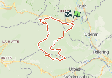
Ruta A pie de 16,6 km a descubrir en Gran Este, Alto Rin, Oderen. Esta ruta ha sido propuesta por boubou68.
Descripción
Départ Chapelle Saint Nicholas..Cheminement le long du Ruisseau St Nicholas vers Col d'Oderen...Tête De Fellering..Le Drumont..FA du Gustiberg..PC 898 m...PC 809 m Abri du Hisel.. Langenbach..Retour Chapelle.
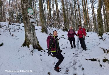
Rando Exigeante !!
Localización
País:
France
Región :
Gran Este
Departamento/provincia :
Alto Rin
Municipio :
Oderen
Localidad:
Unknown
Salida:(Dec)
Salida:(UTM)
347218 ; 5309382 (32T) N.
Comentarios
Excursiones cerca
![Excursión Senderismo Kruth - Autour du lac de Kruth-Wildenstein - Photo](https://media.geolcdn.com/t/375/260/c1e79833-f011-4190-a625-acd1b44dc0b0.jpeg&format=jpg&maxdim=2)
![Senderismo Senderismo](https://static1.geolcdn.com/sitytour/trail-icons/101.png)
Autour du lac de Kruth-Wildenstein
Senderismo
Medio
(1)
Kruth,
Gran Este,
Alto Rin,
France
![](/images/other/stat-length.png)
7,6 km | 12,7 km-effort
3h 15min
![](https://static1.geolcdn.com/siteimages/upload/files/16400158638029165_repeat_loop_refresh_sync_direction_icon.png)
Sí
![Excursión Senderismo Bussang - Col de Bussang - Rouge Gazon - Séchenat - Photo](https://media.geolcdn.com/t/375/260/ext.jpg?maxdim=2&url=https%3A%2F%2Fservices.sitytrail.com%2FGeolivesWS%2FDownloadMedia.ashx%3FTrailID%3D450013%26Media%3Dfix__20150715145430.jpg)
![Senderismo Senderismo](https://static1.geolcdn.com/sitytour/trail-icons/101.png)
Col de Bussang - Rouge Gazon - Séchenat
Senderismo
Difícil
(1)
Bussang,
Gran Este,
Vosgos,
France
![](/images/other/stat-length.png)
15 km | 24 km-effort
6h 0min
![](https://static1.geolcdn.com/siteimages/upload/files/16400158638029165_repeat_loop_refresh_sync_direction_icon.png)
No
![Excursión Senderismo Fellering - Felsach _chapelle ST Nicolas_frenz - Photo](https://media.geolcdn.com/t/375/260/ext.jpg?maxdim=2&url=https%3A%2F%2Fstatic1.geolcdn.com%2Fsiteimages%2Fupload%2Ffiles%2F1553511878bg_sport_marche.png)
![Senderismo Senderismo](https://static1.geolcdn.com/sitytour/trail-icons/101.png)
Felsach _chapelle ST Nicolas_frenz
Senderismo
Difícil
(3)
Fellering,
Gran Este,
Alto Rin,
France
![](/images/other/stat-length.png)
9,6 km | 16,5 km-effort
3h 45min
![](https://static1.geolcdn.com/siteimages/upload/files/16400158638029165_repeat_loop_refresh_sync_direction_icon.png)
Sí
![Excursión Senderismo Oderen - 6146369-Chapelle St Nicolas 2 - Photo](https://media.geolcdn.com/t/375/260/ext.jpg?maxdim=2&url=https%3A%2F%2Fstatic1.geolcdn.com%2Fsiteimages%2Fupload%2Ffiles%2F1553511878bg_sport_marche.png)
![Senderismo Senderismo](https://static1.geolcdn.com/sitytour/trail-icons/101.png)
6146369-Chapelle St Nicolas 2
Senderismo
Medio
(1)
Oderen,
Gran Este,
Alto Rin,
France
![](/images/other/stat-length.png)
10,9 km | 17,9 km-effort
3h 41min
![](https://static1.geolcdn.com/siteimages/upload/files/16400158638029165_repeat_loop_refresh_sync_direction_icon.png)
Sí
![Excursión Senderismo Kruth - barrage de Wildenstein et Grand Ventron - Photo](https://media.geolcdn.com/t/375/260/ext.jpg?maxdim=2&url=https%3A%2F%2Fservices.sitytrail.com%2FGeolivesWS%2FDownloadMedia.ashx%3FTrailID%3D491500%26Media%3Dfix__20151107153447.jpg)
![Senderismo Senderismo](https://static1.geolcdn.com/sitytour/trail-icons/101.png)
barrage de Wildenstein et Grand Ventron
Senderismo
Medio
(1)
Kruth,
Gran Este,
Alto Rin,
France
![](/images/other/stat-length.png)
13,7 km | 24 km-effort
4h 40min
![](https://static1.geolcdn.com/siteimages/upload/files/16400158638029165_repeat_loop_refresh_sync_direction_icon.png)
Sí
![Excursión Senderismo Kruth - le grand Ve tron - Photo](https://media.geolcdn.com/t/375/260/f2c4ef7b-d5ea-4350-b113-528ee63bd3d3.jpg&format=jpg&maxdim=2)
![Senderismo Senderismo](https://static1.geolcdn.com/sitytour/trail-icons/101.png)
le grand Ve tron
Senderismo
Medio
Kruth,
Gran Este,
Alto Rin,
France
![](/images/other/stat-length.png)
15,3 km | 25 km-effort
4h 0min
![](https://static1.geolcdn.com/siteimages/upload/files/16400158638029165_repeat_loop_refresh_sync_direction_icon.png)
No
![Excursión Senderismo Oderen - TREK ALSACIEN (boucle, la meute) - Photo](https://media.geolcdn.com/t/375/260/bce13479-4ed1-47a7-a848-8fc9fefb1457.jpg&format=jpg&maxdim=2)
![Senderismo Senderismo](https://static1.geolcdn.com/sitytour/trail-icons/101.png)
TREK ALSACIEN (boucle, la meute)
Senderismo
Difícil
Oderen,
Gran Este,
Alto Rin,
France
![](/images/other/stat-length.png)
14,3 km | 23 km-effort
4h 30min
![](https://static1.geolcdn.com/siteimages/upload/files/16400158638029165_repeat_loop_refresh_sync_direction_icon.png)
Sí
![Excursión Senderismo Oderen - Oderen Bergenbach Langenbach - Photo](https://media.geolcdn.com/t/375/260/05163254-f106-4300-b7bd-e85eb3e624ac.jpg&format=jpg&maxdim=2)
![Senderismo Senderismo](https://static1.geolcdn.com/sitytour/trail-icons/101.png)
Oderen Bergenbach Langenbach
Senderismo
Medio
Oderen,
Gran Este,
Alto Rin,
France
![](/images/other/stat-length.png)
7,1 km | 11,6 km-effort
3h 40min
![](https://static1.geolcdn.com/siteimages/upload/files/16400158638029165_repeat_loop_refresh_sync_direction_icon.png)
No
![Excursión Senderismo Oderen - TREK ALSACIEN (1ère étape) - Photo](https://media.geolcdn.com/t/375/260/787fe892-71a8-4daf-8eb0-6ad69c3ebb22.jpg&format=jpg&maxdim=2)
![Senderismo Senderismo](https://static1.geolcdn.com/sitytour/trail-icons/101.png)
TREK ALSACIEN (1ère étape)
Senderismo
Medio
Oderen,
Gran Este,
Alto Rin,
France
![](/images/other/stat-length.png)
9,2 km | 18,1 km-effort
4h 0min
![](https://static1.geolcdn.com/siteimages/upload/files/16400158638029165_repeat_loop_refresh_sync_direction_icon.png)
No