![](/images/other/stat-length.png)
![Excursión Senderismo Tanneron - 2024-02-22_23h22m46_randonnee-des-mimosas-tanneron - Photo](https://media.geolcdn.com/t/1900/400/ext.pjpeg?maxdim=2&url=https%3A%2F%2Fstatic1.geolcdn.com%2Fsiteimages%2Fupload%2Ffiles%2F1553511878bg_sport_marche.png)
2024-02-22_23h22m46_randonnee-des-mimosas-tanneron
Renefrt
Usuario
![Longitud](/images/other/stat-length.png)
Longitud
12,4 km
![Altitud máxima](https://static1.geolcdn.com/siteimages/upload/files/1508320355ic_sort_altitude_max_24dp.png)
Altitud máxima
480 m
![Desnivel positivo](https://static1.geolcdn.com/siteimages/upload/files/1508320355ic_sort_den_pos_24dp.png)
Desnivel positivo
371 m
![Km-Effort](/images/other/stat-length.png)
Km-Effort
17,3 km
![Altitud mínima](https://static1.geolcdn.com/siteimages/upload/files/1508320355ic_sort_altitude_min_24dp.png)
Altitud mínima
155 m
![Desnivel negativo](https://static1.geolcdn.com/siteimages/upload/files/1508320355ic_sort_den_neg_24dp.png)
Desnivel negativo
373 m
![Boucle](https://static1.geolcdn.com/siteimages/upload/files/16400158638029165_repeat_loop_refresh_sync_direction_icon.png)
Boucle
Sí
Fecha de creación :
2024-02-22 22:22:46.258
Última modificación :
2024-04-28 13:35:35.871
![Senderismo](https://static1.geolcdn.com/sitytour/trail-icons/101.png)
3h56
Dificultad : Difícil
![Escanee este código QR para abrir la excursión en la aplicación SityTrail](https://capi.geolives.com/qq0zvz2zws4bq2lad0pu/sitytour/trails/3959037/qr.png?size=200)
Aplicación GPS de excursión GRATIS
A propósito
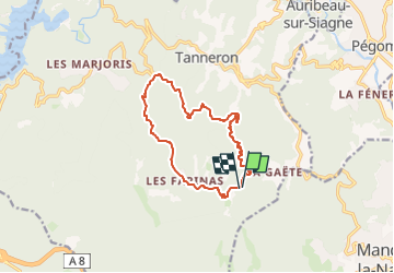
Ruta Senderismo de 12,4 km a descubrir en Provenza-Alpes-Costa Azul, Var, Tanneron. Esta ruta ha sido propuesta por Renefrt.
Descripción
Randonnée des Mimosas - Tanneron
VAriante de ce topo https://docs.wixstatic.com/ugd/7eb3d5_c1511900b96d45719e8154dd6049926e.pdf
DEpart de penier plutot que de Tanneron
Localización
País:
France
Región :
Provenza-Alpes-Costa Azul
Departamento/provincia :
Var
Municipio :
Tanneron
Localidad:
Unknown
Salida:(Dec)
Salida:(UTM)
329341 ; 4825248 (32T) N.
Comentarios
Excursiones cerca
![Excursión Senderismo Mandelieu-la-Napoule - Mont Saint Martin - Photo](https://media.geolcdn.com/t/375/260/ext.jpg?maxdim=2&url=https%3A%2F%2Fservices.sitytrail.com%2FGeolivesWS%2FDownloadMedia.ashx%3FTrailID%3D203071%26Media%3Dfix__20130706124443.jpg)
![Senderismo Senderismo](https://static1.geolcdn.com/sitytour/trail-icons/101.png)
Mont Saint Martin
Senderismo
Fácil
(1)
Mandelieu-la-Napoule,
Provenza-Alpes-Costa Azul,
Alpes Marítimos,
France
![](/images/other/stat-length.png)
9 km | 14,2 km-effort
3h 0min
![](https://static1.geolcdn.com/siteimages/upload/files/16400158638029165_repeat_loop_refresh_sync_direction_icon.png)
Sí
![Excursión Senderismo Tanneron - Tanneron les mimosas - Photo](https://media.geolcdn.com/t/375/260/12594504-e357-426b-8d56-deee61931ae8.jpg&format=jpg&maxdim=2)
![Senderismo Senderismo](https://static1.geolcdn.com/sitytour/trail-icons/101.png)
Tanneron les mimosas
Senderismo
Muy fácil
(1)
Tanneron,
Provenza-Alpes-Costa Azul,
Var,
France
![](/images/other/stat-length.png)
12 km | 17,8 km-effort
3h 25min
![](https://static1.geolcdn.com/siteimages/upload/files/16400158638029165_repeat_loop_refresh_sync_direction_icon.png)
Sí
![Excursión Senderismo Tanneron - Tanneron - petite boucle 12-02-2022 - Photo](https://media.geolcdn.com/t/375/260/4604518f-6a34-43cf-8b51-a998f24d7a22.jpg&format=jpg&maxdim=2)
![Senderismo Senderismo](https://static1.geolcdn.com/sitytour/trail-icons/101.png)
Tanneron - petite boucle 12-02-2022
Senderismo
Fácil
Tanneron,
Provenza-Alpes-Costa Azul,
Var,
France
![](/images/other/stat-length.png)
7,5 km | 10,8 km-effort
2h 0min
![](https://static1.geolcdn.com/siteimages/upload/files/16400158638029165_repeat_loop_refresh_sync_direction_icon.png)
Sí
![Excursión Senderismo Mandelieu-la-Napoule - Grand Duc Alternatif - Photo](https://media.geolcdn.com/t/375/260/ext.jpg?maxdim=2&url=https%3A%2F%2Fstatic1.geolcdn.com%2Fsiteimages%2Fupload%2Ffiles%2F1553511878bg_sport_marche.png)
![Senderismo Senderismo](https://static1.geolcdn.com/sitytour/trail-icons/101.png)
Grand Duc Alternatif
Senderismo
Muy fácil
(1)
Mandelieu-la-Napoule,
Provenza-Alpes-Costa Azul,
Alpes Marítimos,
France
![](/images/other/stat-length.png)
6,4 km | 9,1 km-effort
2h 0min
![](https://static1.geolcdn.com/siteimages/upload/files/16400158638029165_repeat_loop_refresh_sync_direction_icon.png)
Sí
![Excursión Senderismo Mandelieu-la-Napoule -](https://media.geolcdn.com/t/375/260/b86348bf-abb5-455a-82e4-681ad648fdf1.jpg&format=jpg&maxdim=2)
![Senderismo Senderismo](https://static1.geolcdn.com/sitytour/trail-icons/101.png)
"Les oeufs de bouc"
Senderismo
Medio
Mandelieu-la-Napoule,
Provenza-Alpes-Costa Azul,
Alpes Marítimos,
France
![](/images/other/stat-length.png)
14,5 km | 22 km-effort
6h 42min
![](https://static1.geolcdn.com/siteimages/upload/files/16400158638029165_repeat_loop_refresh_sync_direction_icon.png)
Sí
![Excursión Senderismo Mandelieu-la-Napoule - Grand Duc - Photo](https://media.geolcdn.com/t/375/260/bb4952b6-32f3-40dd-b274-07cfc3d80de4.jpg&format=jpg&maxdim=2)
![Senderismo Senderismo](https://static1.geolcdn.com/sitytour/trail-icons/101.png)
Grand Duc
Senderismo
Medio
Mandelieu-la-Napoule,
Provenza-Alpes-Costa Azul,
Alpes Marítimos,
France
![](/images/other/stat-length.png)
8,9 km | 12,5 km-effort
2h 47min
![](https://static1.geolcdn.com/siteimages/upload/files/16400158638029165_repeat_loop_refresh_sync_direction_icon.png)
Sí
![Excursión Senderismo Tanneron - Crêtes du Tanneron - Photo](https://media.geolcdn.com/t/375/260/d09f9b2b-44ce-4ff4-a28b-df768b7c8122.jpg&format=jpg&maxdim=2)
![Senderismo Senderismo](https://static1.geolcdn.com/sitytour/trail-icons/101.png)
Crêtes du Tanneron
Senderismo
Difícil
Tanneron,
Provenza-Alpes-Costa Azul,
Var,
France
![](/images/other/stat-length.png)
14,9 km | 21 km-effort
5h 5min
![](https://static1.geolcdn.com/siteimages/upload/files/16400158638029165_repeat_loop_refresh_sync_direction_icon.png)
Sí
![Excursión Senderismo Mandelieu-la-Napoule - châteaux de la Napoule - Photo](https://media.geolcdn.com/t/375/260/0390d912-0cc3-4a3a-a76c-b7a4f5d42e4b.jpg&format=jpg&maxdim=2)
![Senderismo Senderismo](https://static1.geolcdn.com/sitytour/trail-icons/101.png)
châteaux de la Napoule
Senderismo
Fácil
Mandelieu-la-Napoule,
Provenza-Alpes-Costa Azul,
Alpes Marítimos,
France
![](/images/other/stat-length.png)
5,6 km | 7,8 km-effort
2h 23min
![](https://static1.geolcdn.com/siteimages/upload/files/16400158638029165_repeat_loop_refresh_sync_direction_icon.png)
Sí
![Excursión sport Tanneron - Tanneron - Photo](https://media.geolcdn.com/t/375/260/974aadb2-79c8-4954-8761-9180120909fd.jpg&format=jpg&maxdim=2)
Tanneron
sport
Muy fácil
Tanneron,
Provenza-Alpes-Costa Azul,
Var,
France
![](/images/other/stat-length.png)
9,7 km | 13,9 km-effort
Desconocido
![](https://static1.geolcdn.com/siteimages/upload/files/16400158638029165_repeat_loop_refresh_sync_direction_icon.png)
Sí