![](/images/other/stat-length.png)
SAINT JACQUES D'AMBUR / ANCHALS / ST JACQUES 32kms
Gérard TIXERONT
Usuario GUIDE
![Longitud](/images/other/stat-length.png)
![Altitud máxima](https://static1.geolcdn.com/siteimages/upload/files/1508320355ic_sort_altitude_max_24dp.png)
![Desnivel positivo](https://static1.geolcdn.com/siteimages/upload/files/1508320355ic_sort_den_pos_24dp.png)
![Km-Effort](/images/other/stat-length.png)
![Altitud mínima](https://static1.geolcdn.com/siteimages/upload/files/1508320355ic_sort_altitude_min_24dp.png)
![Desnivel negativo](https://static1.geolcdn.com/siteimages/upload/files/1508320355ic_sort_den_neg_24dp.png)
![Boucle](https://static1.geolcdn.com/siteimages/upload/files/16400158638029165_repeat_loop_refresh_sync_direction_icon.png)
![Paseo ecuestre](https://static1.geolcdn.com/sitytour/trail-icons/301.png)
5h24
Dificultad : Muy difícil
![Escanee este código QR para abrir la excursión en la aplicación SityTrail](https://capi.geolives.com/qq0zvz2zws4bq2lad0pu/sitytour/trails/3938148/qr.png?size=200)
Aplicación GPS de excursión GRATIS
A propósito
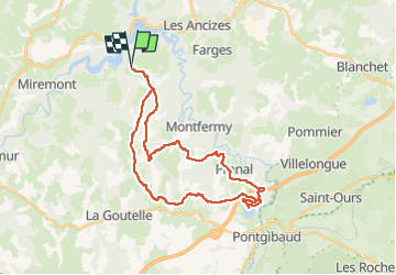
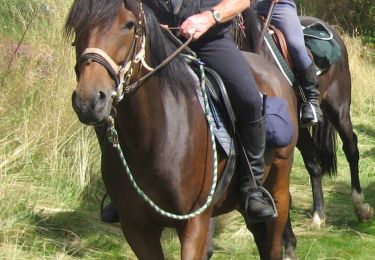
Ruta Paseo ecuestre de 32 km a descubrir en Auvergne-Rhône-Alpes, Puy-de-Dôme, Saint-Jacques-d'Ambur. Esta ruta ha sido propuesta por Gérard TIXERONT.
Descripción
Rando journée en boucle de 32 Kms . Dénivelée important ;
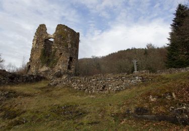
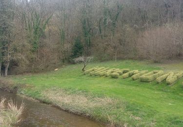
A visiter le village de Pranal avec sa source et son abreuvoir , Le Viaduc de la Sioule , Le Plan d'eau d'Anchals à mi chemin, avec baignade et snack à la saison
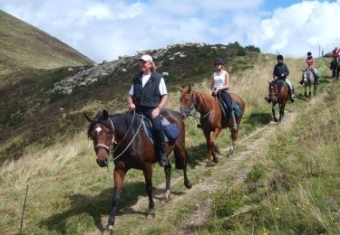
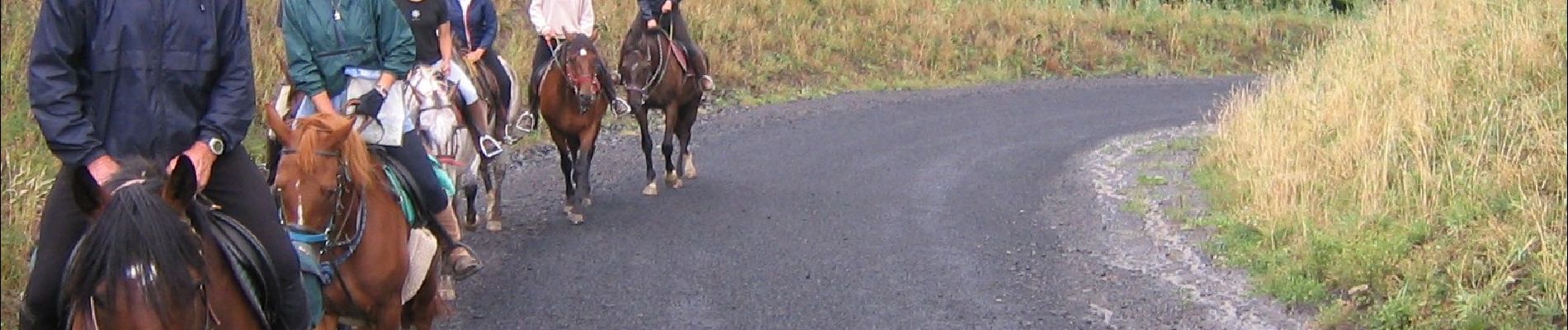
Localización
Comentarios
Excursiones cerca
![Paseo ecuestre Paseo ecuestre](https://static1.geolcdn.com/sitytour/trail-icons/301.png)
Paseo ecuestre
![](/images/other/stat-length.png)
![](https://static1.geolcdn.com/siteimages/upload/files/16400158638029165_repeat_loop_refresh_sync_direction_icon.png)
![Excursión A pie Saint-Jacques-d'Ambur - La Chazotte et les Sapins de Martineche - Photo](https://media.geolcdn.com/t/375/260/b1d91e9c-0a23-4e21-8eff-66a7c5d0369e.jpeg&format=jpg&maxdim=2)
![A pie A pie](https://static1.geolcdn.com/sitytour/trail-icons/100.png)
A pie
![](/images/other/stat-length.png)
![](https://static1.geolcdn.com/siteimages/upload/files/16400158638029165_repeat_loop_refresh_sync_direction_icon.png)
![Excursión A pie Montfermy - Foret Domaniale de la Chartreuse - Photo](https://media.geolcdn.com/t/375/260/f8cfcc7d-f272-48ec-89ad-33d1f7e7ce75.jpeg&format=jpg&maxdim=2)
![A pie A pie](https://static1.geolcdn.com/sitytour/trail-icons/100.png)
A pie
![](/images/other/stat-length.png)
![](https://static1.geolcdn.com/siteimages/upload/files/16400158638029165_repeat_loop_refresh_sync_direction_icon.png)
![Excursión A pie Chapdes-Beaufort - Sur les Pas des Chartreux - Photo](https://media.geolcdn.com/t/375/260/6a67584d-6d2a-4686-9980-b00966620a6c.jpeg&format=jpg&maxdim=2)
![A pie A pie](https://static1.geolcdn.com/sitytour/trail-icons/100.png)
A pie
![](/images/other/stat-length.png)
![](https://static1.geolcdn.com/siteimages/upload/files/16400158638029165_repeat_loop_refresh_sync_direction_icon.png)
![Excursión Senderismo Miremont - Miremont - Photo](https://media.geolcdn.com/t/375/260/0dac0637-e167-46bc-9034-d8c1e64a5534.jpg&format=jpg&maxdim=2)
![Senderismo Senderismo](https://static1.geolcdn.com/sitytour/trail-icons/101.png)
Senderismo
![](/images/other/stat-length.png)
![](https://static1.geolcdn.com/siteimages/upload/files/16400158638029165_repeat_loop_refresh_sync_direction_icon.png)
![Excursión Paseo ecuestre Saint-Jacques-d'Ambur - St JACQUES D'AMBUR / PONTAUMUR / ST JACQUES - Photo](https://media.geolcdn.com/t/375/260/720fba68-32de-48f4-82dd-6eb03edb21f8.jpg&format=jpg&maxdim=2)
![Paseo ecuestre Paseo ecuestre](https://static1.geolcdn.com/sitytour/trail-icons/301.png)
Paseo ecuestre
![](/images/other/stat-length.png)
![](https://static1.geolcdn.com/siteimages/upload/files/16400158638029165_repeat_loop_refresh_sync_direction_icon.png)
![Paseo ecuestre Paseo ecuestre](https://static1.geolcdn.com/sitytour/trail-icons/301.png)
Paseo ecuestre
![](/images/other/stat-length.png)
![](https://static1.geolcdn.com/siteimages/upload/files/16400158638029165_repeat_loop_refresh_sync_direction_icon.png)
![Excursión Paseo ecuestre Saint-Jacques-d'Ambur - ST JACQUES / LE ROCHER DU SOLDAT / ST JACQUES 32 KMS - Photo](https://media.geolcdn.com/t/375/260/d6b0eb37-e064-47bf-bdd4-3b51f5b7a603.jpg&format=jpg&maxdim=2)
![Paseo ecuestre Paseo ecuestre](https://static1.geolcdn.com/sitytour/trail-icons/301.png)
Paseo ecuestre
![](/images/other/stat-length.png)
![](https://static1.geolcdn.com/siteimages/upload/files/16400158638029165_repeat_loop_refresh_sync_direction_icon.png)
![Excursión Paseo ecuestre Saint-Jacques-d'Ambur - SAINT JACQUES D'AMBUR / TIXERONT / ST JACQUES 32 kms - Photo](https://media.geolcdn.com/t/375/260/671897b3-f09f-4ab8-99bb-4ef40c30be95.jpg&format=jpg&maxdim=2)
![Paseo ecuestre Paseo ecuestre](https://static1.geolcdn.com/sitytour/trail-icons/301.png)
Paseo ecuestre
![](/images/other/stat-length.png)
![](https://static1.geolcdn.com/siteimages/upload/files/16400158638029165_repeat_loop_refresh_sync_direction_icon.png)