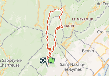
![](/images/other/stat-length.png)
![Excursión Senderismo Saint-Ismier - 030224 Boucle Col de la Faîta - Photo](https://media.geolcdn.com/t/1900/400/2421a004-c833-4d4e-b523-b2ecca29bcbc.jpg&format=pjpeg&maxdim=2)
030224 Boucle Col de la Faîta
mzonzon05
Usuario
![Longitud](/images/other/stat-length.png)
![Altitud máxima](https://static1.geolcdn.com/siteimages/upload/files/1508320355ic_sort_altitude_max_24dp.png)
![Desnivel positivo](https://static1.geolcdn.com/siteimages/upload/files/1508320355ic_sort_den_pos_24dp.png)
![Km-Effort](/images/other/stat-length.png)
![Altitud mínima](https://static1.geolcdn.com/siteimages/upload/files/1508320355ic_sort_altitude_min_24dp.png)
![Desnivel negativo](https://static1.geolcdn.com/siteimages/upload/files/1508320355ic_sort_den_neg_24dp.png)
![Boucle](https://static1.geolcdn.com/siteimages/upload/files/16400158638029165_repeat_loop_refresh_sync_direction_icon.png)
![Senderismo](https://static1.geolcdn.com/sitytour/trail-icons/101.png)
5h25
Dificultad : Muy difícil
![Escanee este código QR para abrir la excursión en la aplicación SityTrail](https://capi.geolives.com/qq0zvz2zws4bq2lad0pu/sitytour/trails/3937954/qr.png?size=200)
Aplicación GPS de excursión GRATIS
A propósito
Ruta Senderismo de 16 km a descubrir en Auvergne-Rhône-Alpes, Isère, Saint-Ismier. Esta ruta ha sido propuesta por mzonzon05.
Descripción
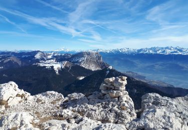
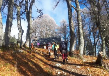
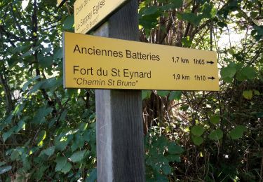
Boucle en forêt certes mais avec un joli chemin et de réguliers points de vue sur la Dent de Crolles, Chamechaude et le Grand Som. Effectuée en février, sans neige et en manches courtes au vu du beau temps, elle doit se faire en toutes saisons (avec des raquettes au besoin).
Localización
Comentarios
Excursiones cerca
![Excursión Senderismo Saint-Nazaire-les-Eymes - Chateau-Nardent par le C9 - Photo](https://media.geolcdn.com/t/375/260/536a5eba-5214-4ffc-98c0-901c667d171a.jpg&format=jpg&maxdim=2)
![Senderismo Senderismo](https://static1.geolcdn.com/sitytour/trail-icons/101.png)
Senderismo
![](/images/other/stat-length.png)
![](https://static1.geolcdn.com/siteimages/upload/files/16400158638029165_repeat_loop_refresh_sync_direction_icon.png)
![Excursión Senderismo Sarcenas - Chamechaude par le Jardin, depuis le Col de Porte - Photo](https://media.geolcdn.com/t/375/260/ext.jpg?maxdim=2&url=https%3A%2F%2Fservices.sitytrail.com%2FGeolivesWS%2FDownloadMedia.ashx%3FTrailID%3D101654%26Media%3D1865_1.jpg)
![Senderismo Senderismo](https://static1.geolcdn.com/sitytour/trail-icons/101.png)
Senderismo
![](/images/other/stat-length.png)
![](https://static1.geolcdn.com/siteimages/upload/files/16400158638029165_repeat_loop_refresh_sync_direction_icon.png)
![Excursión Esquí de fondo Plateau-des-Petites-Roches - Pravouta et bec de Charvet - Photo](https://media.geolcdn.com/t/375/260/b74dc963-a672-4a8f-9168-b0500b4135b1.jpg&format=jpg&maxdim=2)
![Esquí de fondo Esquí de fondo](https://static1.geolcdn.com/sitytour/trail-icons/503.png)
Esquí de fondo
![](/images/other/stat-length.png)
![](https://static1.geolcdn.com/siteimages/upload/files/16400158638029165_repeat_loop_refresh_sync_direction_icon.png)
![Excursión Esquí de fondo Sarcenas - 151224 Vers Chamechaude - Photo](https://media.geolcdn.com/t/375/260/82fefdbb-30e3-407c-be50-449c98f9499e.jpg&format=jpg&maxdim=2)
![Esquí de fondo Esquí de fondo](https://static1.geolcdn.com/sitytour/trail-icons/503.png)
Esquí de fondo
![](/images/other/stat-length.png)
![](https://static1.geolcdn.com/siteimages/upload/files/16400158638029165_repeat_loop_refresh_sync_direction_icon.png)
![Excursión Senderismo Sarcenas - chamchaude par la brèche Arnaud - Photo](https://media.geolcdn.com/t/375/260/a3a4f254-ac9d-4ad4-a4a6-5e5c59427381.jpg&format=jpg&maxdim=2)
![Senderismo Senderismo](https://static1.geolcdn.com/sitytour/trail-icons/101.png)
Senderismo
![](/images/other/stat-length.png)
![](https://static1.geolcdn.com/siteimages/upload/files/16400158638029165_repeat_loop_refresh_sync_direction_icon.png)
![Excursión Senderismo Sarcenas - la Pinéa du col de Portes - Photo](https://media.geolcdn.com/t/375/260/3f1da119-342b-40ef-b4a5-52520786c4f5.jpg&format=jpg&maxdim=2)
![Senderismo Senderismo](https://static1.geolcdn.com/sitytour/trail-icons/101.png)
Senderismo
![](/images/other/stat-length.png)
![](https://static1.geolcdn.com/siteimages/upload/files/16400158638029165_repeat_loop_refresh_sync_direction_icon.png)
![Excursión Senderismo Sarcenas - Chamechaude en circuit partiel au départ du col de Porte - Photo](https://media.geolcdn.com/t/375/260/9aa371e1-099a-4a82-8667-49e92d2df901.jpg&format=jpg&maxdim=2)
![Senderismo Senderismo](https://static1.geolcdn.com/sitytour/trail-icons/101.png)
Senderismo
![](/images/other/stat-length.png)
![](https://static1.geolcdn.com/siteimages/upload/files/16400158638029165_repeat_loop_refresh_sync_direction_icon.png)
![Excursión Senderismo Le Sappey-en-Chartreuse - Belvédère de Roche Rousse en circuit - Photo](https://media.geolcdn.com/t/375/260/260dcdf6-8b65-41b7-963b-3d342c7a013e.jpg&format=jpg&maxdim=2)
![Senderismo Senderismo](https://static1.geolcdn.com/sitytour/trail-icons/101.png)
Senderismo
![](/images/other/stat-length.png)
![](https://static1.geolcdn.com/siteimages/upload/files/16400158638029165_repeat_loop_refresh_sync_direction_icon.png)
![Excursión Senderismo Le Sappey-en-Chartreuse - Sappey_Fort st Eynard - Photo](https://media.geolcdn.com/t/375/260/2b7de198-3791-4b2b-b475-d438d010ae11.jpg&format=jpg&maxdim=2)
![Senderismo Senderismo](https://static1.geolcdn.com/sitytour/trail-icons/101.png)
Senderismo
![](/images/other/stat-length.png)
![](https://static1.geolcdn.com/siteimages/upload/files/16400158638029165_repeat_loop_refresh_sync_direction_icon.png)