![](/images/other/stat-length.png)
![Excursión Senderismo Les Farges - 2024-01-31 13:41 - Photo](https://media.geolcdn.com/t/1900/400/ext.pjpeg?maxdim=2&url=https%3A%2F%2Fstatic1.geolcdn.com%2Fsiteimages%2Fupload%2Ffiles%2F1553511878bg_sport_marche.png)
2024-01-31 13:41
Reider
Usuario
![Longitud](/images/other/stat-length.png)
Longitud
10,9 km
![Altitud máxima](https://static1.geolcdn.com/siteimages/upload/files/1508320355ic_sort_altitude_max_24dp.png)
Altitud máxima
260 m
![Desnivel positivo](https://static1.geolcdn.com/siteimages/upload/files/1508320355ic_sort_den_pos_24dp.png)
Desnivel positivo
311 m
![Km-Effort](/images/other/stat-length.png)
Km-Effort
15,1 km
![Altitud mínima](https://static1.geolcdn.com/siteimages/upload/files/1508320355ic_sort_altitude_min_24dp.png)
Altitud mínima
100 m
![Desnivel negativo](https://static1.geolcdn.com/siteimages/upload/files/1508320355ic_sort_den_neg_24dp.png)
Desnivel negativo
320 m
![Boucle](https://static1.geolcdn.com/siteimages/upload/files/16400158638029165_repeat_loop_refresh_sync_direction_icon.png)
Boucle
Sí
Fecha de creación :
2024-01-31 20:19:44.147
Última modificación :
2024-01-31 20:22:20.737
![Senderismo](https://static1.geolcdn.com/sitytour/trail-icons/101.png)
3h26
Dificultad : Difícil
![Escanee este código QR para abrir la excursión en la aplicación SityTrail](https://capi.geolives.com/qq0zvz2zws4bq2lad0pu/sitytour/trails/3934571/qr.png?size=200)
Aplicación GPS de excursión GRATIS
A propósito
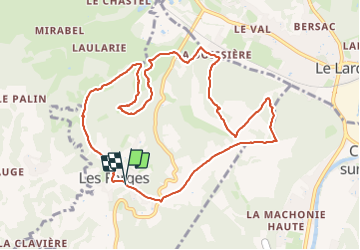
Ruta Senderismo de 10,9 km a descubrir en Nueva Aquitania, Dordogne, Les Farges. Esta ruta ha sido propuesta por Reider.
Descripción
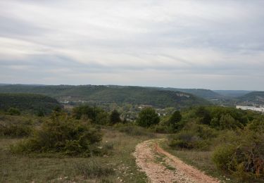
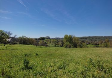
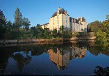
Randonnée qui présente de beau paysages. Un peu de route au départ et à l'arrivée. Il est préférable de la faire au printemps.
Localización
País:
France
Región :
Nueva Aquitania
Departamento/provincia :
Dordogne
Municipio :
Les Farges
Localidad:
Unknown
Salida:(Dec)
Salida:(UTM)
357581 ; 4997317 (31T) N.
Comentarios
Excursiones cerca
![A pie A pie](https://static1.geolcdn.com/sitytour/trail-icons/100.png)
Boucle de la Commanderie
A pie
Fácil
Condat-sur-Vézère,
Nueva Aquitania,
Dordogne,
France
![](/images/other/stat-length.png)
9,5 km | 12,6 km-effort
2h 20min
![](https://static1.geolcdn.com/siteimages/upload/files/16400158638029165_repeat_loop_refresh_sync_direction_icon.png)
Sí
![Excursión Senderismo Les Farges - vezere_6 - Photo](https://media.geolcdn.com/t/375/260/ext.jpg?maxdim=2&url=https%3A%2F%2Fstatic1.geolcdn.com%2Fsiteimages%2Fupload%2Ffiles%2F1553511878bg_sport_marche.png)
![Senderismo Senderismo](https://static1.geolcdn.com/sitytour/trail-icons/101.png)
vezere_6
Senderismo
Medio
(1)
Les Farges,
Nueva Aquitania,
Dordogne,
France
![](/images/other/stat-length.png)
8,7 km | 11,8 km-effort
2h 31min
![](https://static1.geolcdn.com/siteimages/upload/files/16400158638029165_repeat_loop_refresh_sync_direction_icon.png)
Sí
![Excursión Senderismo Les Farges - vezere_5 - Photo](https://media.geolcdn.com/t/375/260/ext.jpg?maxdim=2&url=https%3A%2F%2Fstatic1.geolcdn.com%2Fsiteimages%2Fupload%2Ffiles%2F1553511878bg_sport_marche.png)
![Senderismo Senderismo](https://static1.geolcdn.com/sitytour/trail-icons/101.png)
vezere_5
Senderismo
Medio
(2)
Les Farges,
Nueva Aquitania,
Dordogne,
France
![](/images/other/stat-length.png)
7 km | 9,6 km-effort
2h 3min
![](https://static1.geolcdn.com/siteimages/upload/files/16400158638029165_repeat_loop_refresh_sync_direction_icon.png)
Sí
![Excursión Senderismo Peyrignac - boucle de la nuelle - Photo](https://media.geolcdn.com/t/375/260/b64e44db-eec0-4557-a5fa-c21df1ff17b9.jpg&format=jpg&maxdim=2)
![Senderismo Senderismo](https://static1.geolcdn.com/sitytour/trail-icons/101.png)
boucle de la nuelle
Senderismo
Medio
Peyrignac,
Nueva Aquitania,
Dordogne,
France
![](/images/other/stat-length.png)
6,9 km | 9,3 km-effort
2h 14min
![](https://static1.geolcdn.com/siteimages/upload/files/16400158638029165_repeat_loop_refresh_sync_direction_icon.png)
Sí
![Excursión Senderismo La Bachellerie - Boucle de la Bachellerie - Photo](https://media.geolcdn.com/t/375/260/b70a0e13-8933-44da-8a35-3c81c3bfc9aa.jpg&format=jpg&maxdim=2)
![Senderismo Senderismo](https://static1.geolcdn.com/sitytour/trail-icons/101.png)
Boucle de la Bachellerie
Senderismo
Difícil
La Bachellerie,
Nueva Aquitania,
Dordogne,
France
![](/images/other/stat-length.png)
11,9 km | 15,8 km-effort
3h 35min
![](https://static1.geolcdn.com/siteimages/upload/files/16400158638029165_repeat_loop_refresh_sync_direction_icon.png)
Sí
![Excursión Senderismo Aubas - Circuit des trois châteaux - Photo](https://media.geolcdn.com/t/375/260/a56ae793-bf88-4ec8-9fbe-a570eb23f704.jpg&format=jpg&maxdim=2)
![Senderismo Senderismo](https://static1.geolcdn.com/sitytour/trail-icons/101.png)
Circuit des trois châteaux
Senderismo
Difícil
(2)
Aubas,
Nueva Aquitania,
Dordogne,
France
![](/images/other/stat-length.png)
13,7 km | 18,1 km-effort
4h 7min
![](https://static1.geolcdn.com/siteimages/upload/files/16400158638029165_repeat_loop_refresh_sync_direction_icon.png)
Sí
![Excursión Senderismo Beauregard-de-Terrasson - track - Photo](https://media.geolcdn.com/t/375/260/ext.jpg?maxdim=2&url=https%3A%2F%2Fstatic1.geolcdn.com%2Fsiteimages%2Fupload%2Ffiles%2F1553511878bg_sport_marche.png)
![Senderismo Senderismo](https://static1.geolcdn.com/sitytour/trail-icons/101.png)
track
Senderismo
Difícil
Beauregard-de-Terrasson,
Nueva Aquitania,
Dordogne,
France
![](/images/other/stat-length.png)
11,4 km | 15,7 km-effort
3h 34min
![](https://static1.geolcdn.com/siteimages/upload/files/16400158638029165_repeat_loop_refresh_sync_direction_icon.png)
Sí
![Excursión Senderismo Condat-sur-Vézère - Boucle de Maurival à Condat - Photo](https://media.geolcdn.com/t/375/260/ext.jpg?maxdim=2&url=https%3A%2F%2Fstatic1.geolcdn.com%2Fsiteimages%2Fupload%2Ffiles%2F1553511878bg_sport_marche.png)
![Senderismo Senderismo](https://static1.geolcdn.com/sitytour/trail-icons/101.png)
Boucle de Maurival à Condat
Senderismo
Difícil
Condat-sur-Vézère,
Nueva Aquitania,
Dordogne,
France
![](/images/other/stat-length.png)
12,3 km | 15,7 km-effort
3h 34min
![](https://static1.geolcdn.com/siteimages/upload/files/16400158638029165_repeat_loop_refresh_sync_direction_icon.png)
Sí
![Excursión Senderismo La Bachellerie - la bachellerie (24) azeirat st rabier - Photo](https://media.geolcdn.com/t/375/260/ext.jpg?maxdim=2&url=https%3A%2F%2Fstatic1.geolcdn.com%2Fsiteimages%2Fupload%2Ffiles%2F1553511878bg_sport_marche.png)
![Senderismo Senderismo](https://static1.geolcdn.com/sitytour/trail-icons/101.png)
la bachellerie (24) azeirat st rabier
Senderismo
Difícil
La Bachellerie,
Nueva Aquitania,
Dordogne,
France
![](/images/other/stat-length.png)
12,3 km | 16,3 km-effort
3h 28min
![](https://static1.geolcdn.com/siteimages/upload/files/16400158638029165_repeat_loop_refresh_sync_direction_icon.png)
Sí