![](/images/other/stat-length.png)
![Excursión Senderismo Piriac-sur-Mer - Du port de Piriac-sur-Mer à l'entrée de La Turballe par le GR 34 - Photo](https://media.geolcdn.com/t/1900/400/ext.pjpeg?maxdim=2&url=https%3A%2F%2Fstatic1.geolcdn.com%2Fsiteimages%2Fupload%2Ffiles%2F1553511878bg_sport_marche.png)
Du port de Piriac-sur-Mer à l'entrée de La Turballe par le GR 34
ilur56
Usuario
![Longitud](/images/other/stat-length.png)
![Altitud máxima](https://static1.geolcdn.com/siteimages/upload/files/1508320355ic_sort_altitude_max_24dp.png)
![Desnivel positivo](https://static1.geolcdn.com/siteimages/upload/files/1508320355ic_sort_den_pos_24dp.png)
![Km-Effort](/images/other/stat-length.png)
![Altitud mínima](https://static1.geolcdn.com/siteimages/upload/files/1508320355ic_sort_altitude_min_24dp.png)
![Desnivel negativo](https://static1.geolcdn.com/siteimages/upload/files/1508320355ic_sort_den_neg_24dp.png)
![Boucle](https://static1.geolcdn.com/siteimages/upload/files/16400158638029165_repeat_loop_refresh_sync_direction_icon.png)
![Senderismo](https://static1.geolcdn.com/sitytour/trail-icons/101.png)
2h39
Dificultad : Medio
![Escanee este código QR para abrir la excursión en la aplicación SityTrail](https://capi.geolives.com/qq0zvz2zws4bq2lad0pu/sitytour/trails/3930385/qr.png?size=200)
Aplicación GPS de excursión GRATIS
A propósito
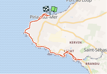
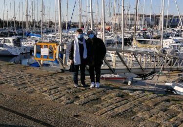
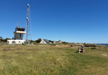
Ruta Senderismo de 10,9 km a descubrir en Países del Loira, Loira-Atlántico, Piriac-sur-Mer. Esta ruta ha sido propuesta por ilur56.
Descripción
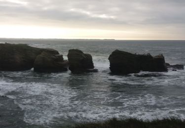
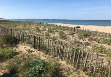
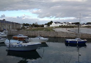
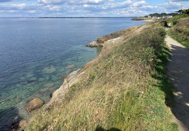
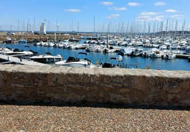
Départ du port de Piriac-sur-Mer à marée descendante pour pouvoir profiter des passages par les plages et éviter le contournement le long de la route côtière; Passage à la pointe du Castelli,et de son sémaphore; Pique-nique à l'étang du Brandu. AVANT un retour par la côte.
Localización
Comentarios
Excursiones cerca
![Excursión Senderismo Piriac-sur-Mer - boucle piriac sur mer - Photo](https://media.geolcdn.com/t/375/260/ea69c10e-c1d1-466e-997c-c1bb043ef6f1.jpg&format=jpg&maxdim=2)
![Senderismo Senderismo](https://static1.geolcdn.com/sitytour/trail-icons/101.png)
Senderismo
![](/images/other/stat-length.png)
![](https://static1.geolcdn.com/siteimages/upload/files/16400158638029165_repeat_loop_refresh_sync_direction_icon.png)
![Excursión Senderismo La Turballe - La Turballe Pen Bron - Photo](https://media.geolcdn.com/t/375/260/eb347f62-ae67-4331-9b20-f94cbabc8a27.jpg&format=jpg&maxdim=2)
![Senderismo Senderismo](https://static1.geolcdn.com/sitytour/trail-icons/101.png)
Senderismo
![](/images/other/stat-length.png)
![](https://static1.geolcdn.com/siteimages/upload/files/16400158638029165_repeat_loop_refresh_sync_direction_icon.png)
![Excursión Senderismo La Turballe - pointe du castelli Piriac Lérat - Photo](https://media.geolcdn.com/t/375/260/ext.jpg?maxdim=2&url=https%3A%2F%2Fservices.sitytrail.com%2FGeolivesWS%2FDownloadMedia.ashx%3FTrailID%3D160296%26Media%3D20121028161408.jpg)
![Senderismo Senderismo](https://static1.geolcdn.com/sitytour/trail-icons/101.png)
Senderismo
![](/images/other/stat-length.png)
![](https://static1.geolcdn.com/siteimages/upload/files/16400158638029165_repeat_loop_refresh_sync_direction_icon.png)
![Excursión Ruta Piriac-sur-Mer - De Piriac à Pointe Merquel(J2 boucle2) - Photo](https://media.geolcdn.com/t/375/260/d448a931-5ebd-49d0-9829-daa8d6573d1b.jpg&format=jpg&maxdim=2)
![Ruta Ruta](https://static1.geolcdn.com/sitytour/trail-icons/104.png)
Ruta
![](/images/other/stat-length.png)
![](https://static1.geolcdn.com/siteimages/upload/files/16400158638029165_repeat_loop_refresh_sync_direction_icon.png)
![Excursión Senderismo Piriac-sur-Mer - Pierre- sémaphore - Photo](https://media.geolcdn.com/t/375/260/e32fcda4-d3b4-45f0-bbf9-fc78c775543a.jpg&format=jpg&maxdim=2)
![Senderismo Senderismo](https://static1.geolcdn.com/sitytour/trail-icons/101.png)
Senderismo
![](/images/other/stat-length.png)
![](https://static1.geolcdn.com/siteimages/upload/files/16400158638029165_repeat_loop_refresh_sync_direction_icon.png)
![Excursión Velero - Crouesty FIN rando nautique - Photo](https://media.geolcdn.com/t/375/260/d70c7b76-7749-44c9-96a5-30e7d72dea51.jpg&format=jpg&maxdim=2)
![Velero Velero](https://static1.geolcdn.com/sitytour/trail-icons/702.png)
![Excursión Senderismo Piriac-sur-Mer - piriac - Photo](https://media.geolcdn.com/t/375/260/183adc7f-acb2-4a52-8322-1c8d8d7b144f.jpg&format=jpg&maxdim=2)
![Senderismo Senderismo](https://static1.geolcdn.com/sitytour/trail-icons/101.png)
Senderismo
![](/images/other/stat-length.png)
![](https://static1.geolcdn.com/siteimages/upload/files/16400158638029165_repeat_loop_refresh_sync_direction_icon.png)
![Excursión Senderismo La Turballe - 01 janvier 2021 - Photo](https://media.geolcdn.com/t/375/260/d414931d-bfb0-4975-9ccd-9999ad5294e4.jpg&format=jpg&maxdim=2)
![Senderismo Senderismo](https://static1.geolcdn.com/sitytour/trail-icons/101.png)
Senderismo
![](/images/other/stat-length.png)
![](https://static1.geolcdn.com/siteimages/upload/files/16400158638029165_repeat_loop_refresh_sync_direction_icon.png)
![Excursión Senderismo Piriac-sur-Mer - cool - Photo](https://media.geolcdn.com/t/375/260/d2ff1d2c-e198-4b2e-9c88-050ef803eef0.jpg&format=jpg&maxdim=2)
![Senderismo Senderismo](https://static1.geolcdn.com/sitytour/trail-icons/101.png)
Senderismo
![](/images/other/stat-length.png)
![](https://static1.geolcdn.com/siteimages/upload/files/16400158638029165_repeat_loop_refresh_sync_direction_icon.png)