![](/images/other/stat-length.png)
![Excursión Senderismo Vandœuvre-lès-Nancy - Nancy (MGN C16) 10 330m +131m - Photo](https://media.geolcdn.com/t/1900/400/ext.pjpeg?maxdim=2&url=https%3A%2F%2Fstatic1.geolcdn.com%2Fsiteimages%2Fupload%2Ffiles%2F1553511878bg_sport_marche.png)
Nancy (MGN C16) 10 330m +131m
DanielROLLET
Usuario
![Longitud](/images/other/stat-length.png)
Longitud
10,3 km
![Altitud máxima](https://static1.geolcdn.com/siteimages/upload/files/1508320355ic_sort_altitude_max_24dp.png)
Altitud máxima
289 m
![Desnivel positivo](https://static1.geolcdn.com/siteimages/upload/files/1508320355ic_sort_den_pos_24dp.png)
Desnivel positivo
131 m
![Km-Effort](/images/other/stat-length.png)
Km-Effort
12,1 km
![Altitud mínima](https://static1.geolcdn.com/siteimages/upload/files/1508320355ic_sort_altitude_min_24dp.png)
Altitud mínima
214 m
![Desnivel negativo](https://static1.geolcdn.com/siteimages/upload/files/1508320355ic_sort_den_neg_24dp.png)
Desnivel negativo
132 m
![Boucle](https://static1.geolcdn.com/siteimages/upload/files/16400158638029165_repeat_loop_refresh_sync_direction_icon.png)
Boucle
Sí
Fecha de creación :
2024-01-20 12:37:01.512
Última modificación :
2024-01-21 08:05:08.524
![Senderismo](https://static1.geolcdn.com/sitytour/trail-icons/101.png)
2h44
Dificultad : Muy fácil
![Escanee este código QR para abrir la excursión en la aplicación SityTrail](https://capi.geolives.com/qq0zvz2zws4bq2lad0pu/sitytour/trails/3921999/qr.png?size=200)
Aplicación GPS de excursión GRATIS
A propósito
Ruta Senderismo de 10,3 km a descubrir en Gran Este, Meurthe y Mosela, Vandœuvre-lès-Nancy. Esta ruta ha sido propuesta por DanielROLLET.
Descripción
2024 01 20 - 13h40 à 16h00 - Avec Marie
Contrôle MGN C16
Départ/retour du domicile
Trés beau temps sec (0°)
Localización
País:
France
Región :
Gran Este
Departamento/provincia :
Meurthe y Mosela
Municipio :
Vandœuvre-lès-Nancy
Localidad:
Unknown
Salida:(Dec)
Salida:(UTM)
292920 ; 5395338 (32U) N.
Comentarios
Excursiones cerca
![Excursión A pie Agincourt - Circuit M - Photo](https://media.geolcdn.com/t/375/260/af3027bd-6d38-4135-8a9f-8cca4de624d0.jpeg&format=jpg&maxdim=2)
![A pie A pie](https://static1.geolcdn.com/sitytour/trail-icons/100.png)
Circuit M
A pie
Fácil
Agincourt,
Gran Este,
Meurthe y Mosela,
France
![](/images/other/stat-length.png)
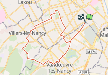
13,3 km | 17,8 km-effort
4h 3min
![](https://static1.geolcdn.com/siteimages/upload/files/16400158638029165_repeat_loop_refresh_sync_direction_icon.png)
No
![Excursión Senderismo Nancy - Ma dernière avant opération - Photo](https://media.geolcdn.com/t/375/260/ext.jpg?maxdim=2&url=https%3A%2F%2Fstatic1.geolcdn.com%2Fsiteimages%2Fupload%2Ffiles%2F1553511878bg_sport_marche.png)
![Senderismo Senderismo](https://static1.geolcdn.com/sitytour/trail-icons/101.png)
Ma dernière avant opération
Senderismo
Muy difícil
(1)
Nancy,
Gran Este,
Meurthe y Mosela,
France
![](/images/other/stat-length.png)
22 km | 25 km-effort
4h 12min
![](https://static1.geolcdn.com/siteimages/upload/files/16400158638029165_repeat_loop_refresh_sync_direction_icon.png)
Sí
![Excursión Senderismo Vandœuvre-lès-Nancy - Randonnée USEP 2023 - Photo](https://media.geolcdn.com/t/375/260/ext.jpg?maxdim=2&url=https%3A%2F%2Fstatic1.geolcdn.com%2Fsiteimages%2Fupload%2Ffiles%2F1553511878bg_sport_marche.png)
![Senderismo Senderismo](https://static1.geolcdn.com/sitytour/trail-icons/101.png)
Randonnée USEP 2023
Senderismo
Difícil
(1)
Vandœuvre-lès-Nancy,
Gran Este,
Meurthe y Mosela,
France
![](/images/other/stat-length.png)
11,7 km | 15,2 km-effort
3h 27min
![](https://static1.geolcdn.com/siteimages/upload/files/16400158638029165_repeat_loop_refresh_sync_direction_icon.png)
No
![Excursión Senderismo Nancy - Ma rando du jour - Photo](https://media.geolcdn.com/t/375/260/c990ad83-2661-43f9-99e0-4498fd5d020a.jpg&format=jpg&maxdim=2)
![Senderismo Senderismo](https://static1.geolcdn.com/sitytour/trail-icons/101.png)
Ma rando du jour
Senderismo
Difícil
Nancy,
Gran Este,
Meurthe y Mosela,
France
![](/images/other/stat-length.png)
35 km | 41 km-effort
5h 55min
![](https://static1.geolcdn.com/siteimages/upload/files/16400158638029165_repeat_loop_refresh_sync_direction_icon.png)
Sí
![Excursión Senderismo Nancy - Nancy Gondreville Nancy - Photo](https://media.geolcdn.com/t/375/260/171b4f53-1717-4b2e-9789-6c40dd8e1481.jpg&format=jpg&maxdim=2)
![Senderismo Senderismo](https://static1.geolcdn.com/sitytour/trail-icons/101.png)
Nancy Gondreville Nancy
Senderismo
Difícil
Nancy,
Gran Este,
Meurthe y Mosela,
France
![](/images/other/stat-length.png)
64 km | 74 km-effort
10h 57min
![](https://static1.geolcdn.com/siteimages/upload/files/16400158638029165_repeat_loop_refresh_sync_direction_icon.png)
Sí
![Excursión Senderismo Nancy - Nancy Saizeray Jaillon Pierre la Treiche Marion Nancy - Photo](https://media.geolcdn.com/t/375/260/9e40712a-6db3-4fe8-9edd-58851d16cb4f.jpg&format=jpg&maxdim=2)
![Senderismo Senderismo](https://static1.geolcdn.com/sitytour/trail-icons/101.png)
Nancy Saizeray Jaillon Pierre la Treiche Marion Nancy
Senderismo
Difícil
Nancy,
Gran Este,
Meurthe y Mosela,
France
![](/images/other/stat-length.png)
73 km | 85 km-effort
12h 13min
![](https://static1.geolcdn.com/siteimages/upload/files/16400158638029165_repeat_loop_refresh_sync_direction_icon.png)
Sí
![Excursión A pie Villers-lès-Nancy - Promenade d'Hardeval - Photo](https://media.geolcdn.com/t/375/260/43cb5da8-59dd-45f8-ae11-ca17f70000c7.jpeg&format=jpg&maxdim=2)
![A pie A pie](https://static1.geolcdn.com/sitytour/trail-icons/100.png)
Promenade d'Hardeval
A pie
Fácil
Villers-lès-Nancy,
Gran Este,
Meurthe y Mosela,
France
![](/images/other/stat-length.png)
3,2 km | 4,3 km-effort
58min
![](https://static1.geolcdn.com/siteimages/upload/files/16400158638029165_repeat_loop_refresh_sync_direction_icon.png)
Sí
![Excursión A pie Champigneulles - Circuit de Bellefontaine - général ouest - Photo](https://media.geolcdn.com/t/375/260/afefad02-ca10-49a0-94f8-a0d611ca2a91.jpeg&format=jpg&maxdim=2)
![A pie A pie](https://static1.geolcdn.com/sitytour/trail-icons/100.png)
Circuit de Bellefontaine - général ouest
A pie
Fácil
Champigneulles,
Gran Este,
Meurthe y Mosela,
France
![](/images/other/stat-length.png)
6,1 km | 8 km-effort
1h 48min
![](https://static1.geolcdn.com/siteimages/upload/files/16400158638029165_repeat_loop_refresh_sync_direction_icon.png)
No
![Excursión Senderismo Nancy - Nancy - Gondreville - Nancy - Photo](https://media.geolcdn.com/t/375/260/1ba94617-550e-4800-a823-8e357aef3619.jpg&format=jpg&maxdim=2)
![Senderismo Senderismo](https://static1.geolcdn.com/sitytour/trail-icons/101.png)
Nancy - Gondreville - Nancy
Senderismo
Medio
Nancy,
Gran Este,
Meurthe y Mosela,
France
![](/images/other/stat-length.png)
64 km | 74 km-effort
24h 59min
![](https://static1.geolcdn.com/siteimages/upload/files/16400158638029165_repeat_loop_refresh_sync_direction_icon.png)
Sí