![](/images/other/stat-length.png)
![Excursión Senderismo Caussols - Calern - Photo](https://media.geolcdn.com/t/1900/400/05a59553-03ef-4163-b36a-14c996b125d5.jpg&format=pjpeg&maxdim=2)
Calern
Renefrt
Usuario
![Longitud](/images/other/stat-length.png)
Longitud
11,2 km
![Altitud máxima](https://static1.geolcdn.com/siteimages/upload/files/1508320355ic_sort_altitude_max_24dp.png)
Altitud máxima
1271 m
![Desnivel positivo](https://static1.geolcdn.com/siteimages/upload/files/1508320355ic_sort_den_pos_24dp.png)
Desnivel positivo
378 m
![Km-Effort](/images/other/stat-length.png)
Km-Effort
16,2 km
![Altitud mínima](https://static1.geolcdn.com/siteimages/upload/files/1508320355ic_sort_altitude_min_24dp.png)
Altitud mínima
945 m
![Desnivel negativo](https://static1.geolcdn.com/siteimages/upload/files/1508320355ic_sort_den_neg_24dp.png)
Desnivel negativo
378 m
![Boucle](https://static1.geolcdn.com/siteimages/upload/files/16400158638029165_repeat_loop_refresh_sync_direction_icon.png)
Boucle
Sí
Fecha de creación :
2023-12-07 07:59:51.0
Última modificación :
2023-12-14 05:40:15.786
![Senderismo](https://static1.geolcdn.com/sitytour/trail-icons/101.png)
5h56
Dificultad : Medio
![Escanee este código QR para abrir la excursión en la aplicación SityTrail](https://capi.geolives.com/qq0zvz2zws4bq2lad0pu/sitytour/trails/3892284/qr.png?size=200)
Aplicación GPS de excursión GRATIS
A propósito
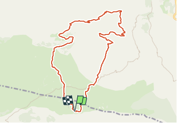
Ruta Senderismo de 11,2 km a descubrir en Provenza-Alpes-Costa Azul, Alpes Marítimos, Caussols. Esta ruta ha sido propuesta por Renefrt.
Descripción
Aussi agréable au printemps automne qu’en hiver.
Si ce n’est quelques cabanes de bergers on se croirait sur une autre planète.
Comme on le dit tous les chemins ou travers du plateau ramènent au parking. Pas grave si on ne suit pas la trace.
Localización
País:
France
Región :
Provenza-Alpes-Costa Azul
Departamento/provincia :
Alpes Marítimos
Municipio :
Caussols
Localidad:
Unknown
Salida:(Dec)
Salida:(UTM)
332866 ; 4846366 (32T) N.
Comentarios
Excursiones cerca
![Excursión Senderismo Gourdon - Plateau de Cavillore, la Forteresse - Gourdon - Photo](https://media.geolcdn.com/t/375/260/ext.jpg?maxdim=2&url=https%3A%2F%2Fservices.sitytrail.com%2FGeolivesWS%2FDownloadMedia.ashx%3FTrailID%3D214895%26Media%3D15446_1.jpg)
![Senderismo Senderismo](https://static1.geolcdn.com/sitytour/trail-icons/101.png)
Plateau de Cavillore, la Forteresse - Gourdon
Senderismo
Medio
(3)
Gourdon,
Provenza-Alpes-Costa Azul,
Alpes Marítimos,
France
![](/images/other/stat-length.png)
7,2 km | 11,2 km-effort
2h 15min
![](https://static1.geolcdn.com/siteimages/upload/files/16400158638029165_repeat_loop_refresh_sync_direction_icon.png)
Sí
![Excursión Senderismo Caussols - Le Haut Montet 1335m, Plateau de Caussols - Photo](https://media.geolcdn.com/t/375/260/ext.jpg?maxdim=2&url=https%3A%2F%2Fservices.sitytrail.com%2FGeolivesWS%2FDownloadMedia.ashx%3FTrailID%3D214865%26Media%3D15407_1.jpg)
![Senderismo Senderismo](https://static1.geolcdn.com/sitytour/trail-icons/101.png)
Le Haut Montet 1335m, Plateau de Caussols
Senderismo
Fácil
(1)
Caussols,
Provenza-Alpes-Costa Azul,
Alpes Marítimos,
France
![](/images/other/stat-length.png)
13,5 km | 18,6 km-effort
4h 0min
![](https://static1.geolcdn.com/siteimages/upload/files/16400158638029165_repeat_loop_refresh_sync_direction_icon.png)
Sí
![Excursión Senderismo Cipières - Cipières Sommet de Calern - Grotte de ND de Calern - Photo](https://media.geolcdn.com/t/375/260/dcc22407-202f-49e5-a220-25d384f38a74.jpg&format=jpg&maxdim=2)
![Senderismo Senderismo](https://static1.geolcdn.com/sitytour/trail-icons/101.png)
Cipières Sommet de Calern - Grotte de ND de Calern
Senderismo
Muy difícil
Cipières,
Provenza-Alpes-Costa Azul,
Alpes Marítimos,
France
![](/images/other/stat-length.png)
21 km | 31 km-effort
7h 20min
![](https://static1.geolcdn.com/siteimages/upload/files/16400158638029165_repeat_loop_refresh_sync_direction_icon.png)
No
![Excursión A pie Gourdon - Plateau de Cavillore - Photo](https://media.geolcdn.com/t/375/260/094c0018-0a4d-4f34-8879-15bc82519f15.jpeg&format=jpg&maxdim=2)
![A pie A pie](https://static1.geolcdn.com/sitytour/trail-icons/100.png)
Plateau de Cavillore
A pie
Fácil
Gourdon,
Provenza-Alpes-Costa Azul,
Alpes Marítimos,
France
![](/images/other/stat-length.png)
5,9 km | 10 km-effort
2h 16min
![](https://static1.geolcdn.com/siteimages/upload/files/16400158638029165_repeat_loop_refresh_sync_direction_icon.png)
Sí
![Excursión A pie Caussols - Plateau de Caussols - Photo](https://media.geolcdn.com/t/375/260/598f9742-6bcf-489a-8a9a-6409dd2e2888.jpeg&format=jpg&maxdim=2)
![A pie A pie](https://static1.geolcdn.com/sitytour/trail-icons/100.png)
Plateau de Caussols
A pie
Fácil
Caussols,
Provenza-Alpes-Costa Azul,
Alpes Marítimos,
France
![](/images/other/stat-length.png)
13,9 km | 19,1 km-effort
4h 20min
![](https://static1.geolcdn.com/siteimages/upload/files/16400158638029165_repeat_loop_refresh_sync_direction_icon.png)
Sí
![Excursión A pie Cipières - Traversée de l'Estéron - Etape 2 - Photo](https://media.geolcdn.com/t/375/260/ebd4d990-1504-43f1-96fb-3c8749b403dd.jpeg&format=jpg&maxdim=2)
![A pie A pie](https://static1.geolcdn.com/sitytour/trail-icons/100.png)
Traversée de l'Estéron - Etape 2
A pie
Difícil
Cipières,
Provenza-Alpes-Costa Azul,
Alpes Marítimos,
France
![](/images/other/stat-length.png)
21 km | 41 km-effort
9h 18min
![](https://static1.geolcdn.com/siteimages/upload/files/16400158638029165_repeat_loop_refresh_sync_direction_icon.png)
No
![Excursión A pie Cipières - Traversée de l'Estéron - Etape 1 - Photo](https://media.geolcdn.com/t/375/260/0e49d622-3c08-45d7-a080-59d63fc9110b.jpeg&format=jpg&maxdim=2)
![A pie A pie](https://static1.geolcdn.com/sitytour/trail-icons/100.png)
Traversée de l'Estéron - Etape 1
A pie
Medio
Cipières,
Provenza-Alpes-Costa Azul,
Alpes Marítimos,
France
![](/images/other/stat-length.png)
18,4 km | 29 km-effort
6h 28min
![](https://static1.geolcdn.com/siteimages/upload/files/16400158638029165_repeat_loop_refresh_sync_direction_icon.png)
No
![Excursión A pie Cipières - Plateau de Calern - Photo](https://media.geolcdn.com/t/375/260/04069cc7-0f77-41ab-bace-443cac173cb2.jpeg&format=jpg&maxdim=2)
![A pie A pie](https://static1.geolcdn.com/sitytour/trail-icons/100.png)
Plateau de Calern
A pie
Medio
Cipières,
Provenza-Alpes-Costa Azul,
Alpes Marítimos,
France
![](/images/other/stat-length.png)
13,5 km | 21 km-effort
4h 44min
![](https://static1.geolcdn.com/siteimages/upload/files/16400158638029165_repeat_loop_refresh_sync_direction_icon.png)
Sí
![Excursión A pie Gréolières - Circuit du Loup - Photo](https://media.geolcdn.com/t/375/260/09dfa2b7-7900-471b-b9af-79ed74d6292b.jpeg&format=jpg&maxdim=2)
![A pie A pie](https://static1.geolcdn.com/sitytour/trail-icons/100.png)
Circuit du Loup
A pie
Fácil
Gréolières,
Provenza-Alpes-Costa Azul,
Alpes Marítimos,
France
![](/images/other/stat-length.png)
6,5 km | 12,7 km-effort
2h 52min
![](https://static1.geolcdn.com/siteimages/upload/files/16400158638029165_repeat_loop_refresh_sync_direction_icon.png)
Sí