![](/images/other/stat-length.png)
PARC et LACS PLITVICE (Croatie)
Miclm
Usuario
![Longitud](/images/other/stat-length.png)
![Altitud máxima](https://static1.geolcdn.com/siteimages/upload/files/1508320355ic_sort_altitude_max_24dp.png)
![Desnivel positivo](https://static1.geolcdn.com/siteimages/upload/files/1508320355ic_sort_den_pos_24dp.png)
![Km-Effort](/images/other/stat-length.png)
![Altitud mínima](https://static1.geolcdn.com/siteimages/upload/files/1508320355ic_sort_altitude_min_24dp.png)
![Desnivel negativo](https://static1.geolcdn.com/siteimages/upload/files/1508320355ic_sort_den_neg_24dp.png)
![Boucle](https://static1.geolcdn.com/siteimages/upload/files/16400158638029165_repeat_loop_refresh_sync_direction_icon.png)
![Senderismo](https://static1.geolcdn.com/sitytour/trail-icons/101.png)
5h07
Dificultad : Muy difícil
![Escanee este código QR para abrir la excursión en la aplicación SityTrail](https://capi.geolives.com/qq0zvz2zws4bq2lad0pu/sitytour/trails/3891608/qr.png?size=200)
Aplicación GPS de excursión GRATIS
A propósito
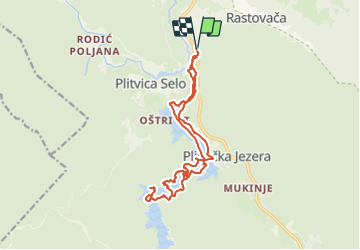
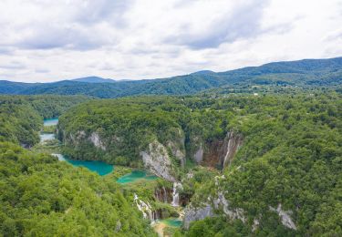
Ruta Senderismo de 16,9 km a descubrir en Desconocido, Ličko-senjska županija. Esta ruta ha sido propuesta por Miclm.
Descripción
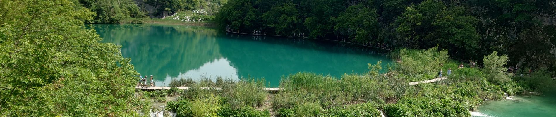
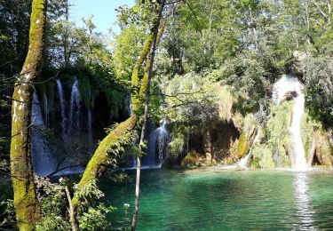
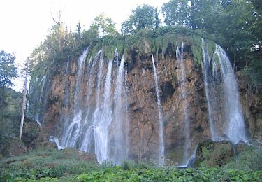
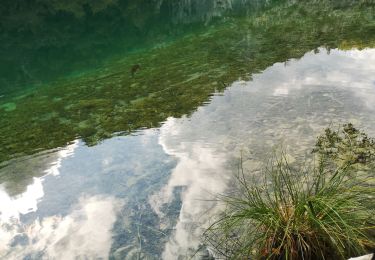
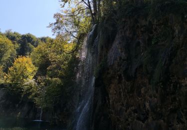
Marche facile avec des paysages, lacs et cascades époustouflants. 16 lacs se déversent les uns dans les autres grâce à 92 cascades .
Réserver à l'avance et choisir de faire la marche le plus tôt possible pour éviter la cohue.
Le même ticket d'entrée est valable pour tout le Parc quelque soit le parcours que l'on choisi de 3.5 à 18 km.
Selon les période la totalité du parcours n'est pas toujours ouvert.
pour les moins courageux il y a des passages en train et en bateau, nous avons pris le bateau pour aller d'une station à l'autre car le chemin était fermé puis au retour juste pour traverser un lac et rentrer à pied.
les chiens tenus en laisse sont acceptés
Nous étions en Van il y a un parking bus et CC près de l'entrée 1 et pour être à l'ouverture du parc nous avons campé au Camp Bear situé à 5km.
Localización
Comentarios
Excursiones cerca
![Excursión Senderismo - Parc National Plitviche 05/08/18 - Photo](https://media.geolcdn.com/t/375/260/9716ac76-ab05-4ed1-9864-5f2e7127f823.jpg&format=jpg&maxdim=2)
![Senderismo Senderismo](https://static1.geolcdn.com/sitytour/trail-icons/101.png)
Senderismo
![](/images/other/stat-length.png)
![](https://static1.geolcdn.com/siteimages/upload/files/16400158638029165_repeat_loop_refresh_sync_direction_icon.png)
![Excursión A pie - Pješačka ruta K2 - Photo](https://media.geolcdn.com/t/375/260/932dd9f0-f45a-4e85-83ac-fe7a12eb467e.jpeg&format=jpg&maxdim=2)
![A pie A pie](https://static1.geolcdn.com/sitytour/trail-icons/100.png)
A pie
![](/images/other/stat-length.png)
![](https://static1.geolcdn.com/siteimages/upload/files/16400158638029165_repeat_loop_refresh_sync_direction_icon.png)
![Excursión A pie - Pješačka ruta K1 - Photo](https://media.geolcdn.com/t/375/260/a49d43b6-634e-41ff-b40e-9fa8f3cc9ff8.jpeg&format=jpg&maxdim=2)
![A pie A pie](https://static1.geolcdn.com/sitytour/trail-icons/100.png)
A pie
![](/images/other/stat-length.png)
![](https://static1.geolcdn.com/siteimages/upload/files/16400158638029165_repeat_loop_refresh_sync_direction_icon.png)
![Excursión A pie - Pješačka ruta A - Photo](https://media.geolcdn.com/t/375/260/a49d43b6-634e-41ff-b40e-9fa8f3cc9ff8.jpeg&format=jpg&maxdim=2)
![A pie A pie](https://static1.geolcdn.com/sitytour/trail-icons/100.png)
A pie
![](/images/other/stat-length.png)
![](https://static1.geolcdn.com/siteimages/upload/files/16400158638029165_repeat_loop_refresh_sync_direction_icon.png)
![Excursión Senderismo - Lacs de Plitvice - Photo](https://media.geolcdn.com/t/375/260/f73eefe8-9160-45f6-af70-b85889f3f88e.jpg&format=jpg&maxdim=2)
![Senderismo Senderismo](https://static1.geolcdn.com/sitytour/trail-icons/101.png)
Senderismo
![](/images/other/stat-length.png)
![](https://static1.geolcdn.com/siteimages/upload/files/16400158638029165_repeat_loop_refresh_sync_direction_icon.png)
![Excursión Senderismo - Lacs de Plitvice - Photo](https://media.geolcdn.com/t/375/260/c090ff67-4512-42a1-9ba4-5c2a3953f822.jpg&format=jpg&maxdim=2)
![Senderismo Senderismo](https://static1.geolcdn.com/sitytour/trail-icons/101.png)
Senderismo
![](/images/other/stat-length.png)
![](https://static1.geolcdn.com/siteimages/upload/files/16400158638029165_repeat_loop_refresh_sync_direction_icon.png)
![Excursión Senderismo - cascades - Photo](https://media.geolcdn.com/t/375/260/f7f95bad-3aed-48a3-b1ee-55eebc3e5468.jpg&format=jpg&maxdim=2)
![Senderismo Senderismo](https://static1.geolcdn.com/sitytour/trail-icons/101.png)
Senderismo
![](/images/other/stat-length.png)
![](https://static1.geolcdn.com/siteimages/upload/files/16400158638029165_repeat_loop_refresh_sync_direction_icon.png)
![Excursión Senderismo - plivice - Photo](https://media.geolcdn.com/t/375/260/ext.jpg?maxdim=2&url=https%3A%2F%2Fstatic1.geolcdn.com%2Fsiteimages%2Fupload%2Ffiles%2F1553511878bg_sport_marche.png)
![Senderismo Senderismo](https://static1.geolcdn.com/sitytour/trail-icons/101.png)
Senderismo
![](/images/other/stat-length.png)
![](https://static1.geolcdn.com/siteimages/upload/files/16400158638029165_repeat_loop_refresh_sync_direction_icon.png)
![Excursión Senderismo - CROATIE parc de PLITVICE - Photo](https://media.geolcdn.com/t/375/260/ext.jpg?maxdim=2&url=https%3A%2F%2Fstatic1.geolcdn.com%2Fsiteimages%2Fupload%2Ffiles%2F1553511878bg_sport_marche.png)
![Senderismo Senderismo](https://static1.geolcdn.com/sitytour/trail-icons/101.png)
Senderismo
![](/images/other/stat-length.png)
![](https://static1.geolcdn.com/siteimages/upload/files/16400158638029165_repeat_loop_refresh_sync_direction_icon.png)
Merci beaucoup pour ce partage.