![](/images/other/stat-length.png)
![Excursión Senderismo Séchilienne - Col de la Madeleine en circuit - Photo](https://media.geolcdn.com/t/1900/400/3add82a1-c10f-42f3-9d0e-db81a4e2134f.jpg&format=pjpeg&maxdim=2)
Col de la Madeleine en circuit
Emelle
Usuario
![Longitud](/images/other/stat-length.png)
Longitud
11,3 km
![Altitud máxima](https://static1.geolcdn.com/siteimages/upload/files/1508320355ic_sort_altitude_max_24dp.png)
Altitud máxima
1272 m
![Desnivel positivo](https://static1.geolcdn.com/siteimages/upload/files/1508320355ic_sort_den_pos_24dp.png)
Desnivel positivo
864 m
![Km-Effort](/images/other/stat-length.png)
Km-Effort
23 km
![Altitud mínima](https://static1.geolcdn.com/siteimages/upload/files/1508320355ic_sort_altitude_min_24dp.png)
Altitud mínima
408 m
![Desnivel negativo](https://static1.geolcdn.com/siteimages/upload/files/1508320355ic_sort_den_neg_24dp.png)
Desnivel negativo
863 m
![Boucle](https://static1.geolcdn.com/siteimages/upload/files/16400158638029165_repeat_loop_refresh_sync_direction_icon.png)
Boucle
Sí
Fecha de creación :
2023-12-10 07:50:42.116
Última modificación :
2023-12-12 12:55:23.28
![Senderismo](https://static1.geolcdn.com/sitytour/trail-icons/101.png)
4h09
Dificultad : Medio
![Escanee este código QR para abrir la excursión en la aplicación SityTrail](https://capi.geolives.com/qq0zvz2zws4bq2lad0pu/sitytour/trails/3889329/qr.png?size=200)
Aplicación GPS de excursión GRATIS
A propósito
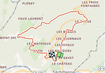
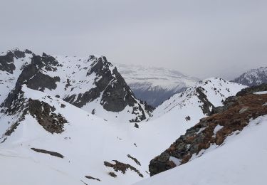
Ruta Senderismo de 11,3 km a descubrir en Auvergne-Rhône-Alpes, Isère, Séchilienne. Esta ruta ha sido propuesta por Emelle.
Descripción
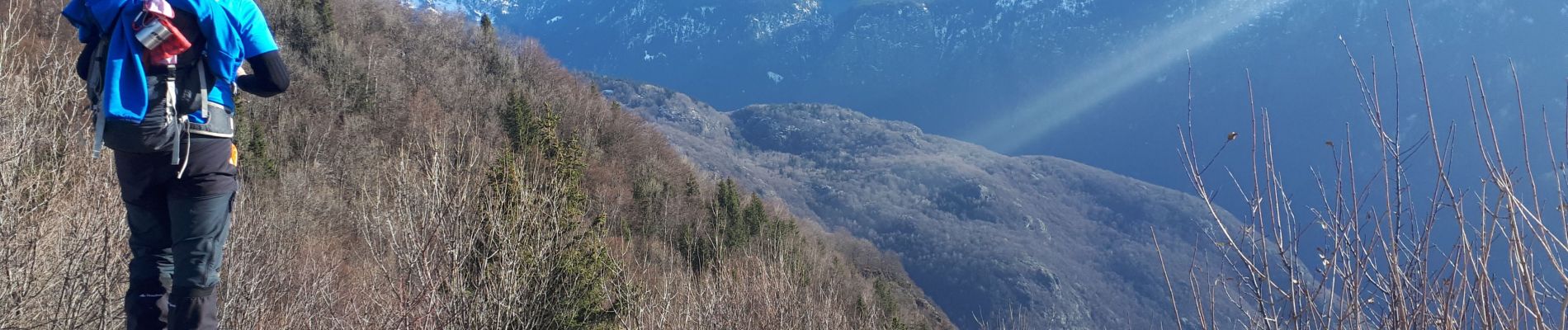
Petits ruisseaux sur la partie basse des Pavies de Séchilienne du fait des fortes pluies les jours précédents et la fonte des neiges, rendant la montée glissante. Pavies qu'il vaut mieux monter que descendre de fait.
Localización
País:
France
Región :
Auvergne-Rhône-Alpes
Departamento/provincia :
Isère
Municipio :
Séchilienne
Localidad:
Unknown
Salida:(Dec)
Salida:(UTM)
722847 ; 4993346 (31T) N.
Comentarios
Excursiones cerca
![Excursión Raquetas de nieve La Morte - Belvedere et Balcon de La Romanche - Photo](https://media.geolcdn.com/t/375/260/ext.jpg?maxdim=2&url=https%3A%2F%2Fservices.sitytrail.com%2FGeolivesWS%2FDownloadMedia.ashx%3FTrailID%3D911113%26Media%3Dfix__20180222125140.jpg)
![Raquetas de nieve Raquetas de nieve](https://static1.geolcdn.com/sitytour/trail-icons/504.png)
Belvedere et Balcon de La Romanche
Raquetas de nieve
Medio
(1)
La Morte,
Auvergne-Rhône-Alpes,
Isère,
France
![](/images/other/stat-length.png)
10,3 km | 16,8 km-effort
4h 18min
![](https://static1.geolcdn.com/siteimages/upload/files/16400158638029165_repeat_loop_refresh_sync_direction_icon.png)
Sí
![Excursión Carrera Vizille - Echappée Belle 2013 - Photo](https://media.geolcdn.com/t/375/260/ext.jpg?maxdim=2&url=https%3A%2F%2Fstatic1.geolcdn.com%2Fsiteimages%2Fupload%2Ffiles%2F1524743154running.jpg)
![Carrera Carrera](https://static1.geolcdn.com/sitytour/trail-icons/103.png)
Echappée Belle 2013
Carrera
Muy difícil
(1)
Vizille,
Auvergne-Rhône-Alpes,
Isère,
France
![](/images/other/stat-length.png)
136 km | 279 km-effort
60h 0min
![](https://static1.geolcdn.com/siteimages/upload/files/16400158638029165_repeat_loop_refresh_sync_direction_icon.png)
No
![Excursión Senderismo Séchilienne - Lac de Luitel - Pic de l'oeilly - Photo](https://media.geolcdn.com/t/375/260/392243d2-0bef-4c0e-a978-68f4c5437966.jpg&format=jpg&maxdim=2)
![Senderismo Senderismo](https://static1.geolcdn.com/sitytour/trail-icons/101.png)
Lac de Luitel - Pic de l'oeilly
Senderismo
Fácil
Séchilienne,
Auvergne-Rhône-Alpes,
Isère,
France
![](/images/other/stat-length.png)
7,3 km | 11,1 km-effort
2h 26min
![](https://static1.geolcdn.com/siteimages/upload/files/16400158638029165_repeat_loop_refresh_sync_direction_icon.png)
Sí
![Excursión Senderismo Vaulnaveys-le-Haut - Le Lac Achard - Le Col de L'Infernet - Photo](https://media.geolcdn.com/t/375/260/2b2ec1fe-50ad-47bf-b539-f816d718554b.jpg&format=jpg&maxdim=2)
![Senderismo Senderismo](https://static1.geolcdn.com/sitytour/trail-icons/101.png)
Le Lac Achard - Le Col de L'Infernet
Senderismo
Medio
Vaulnaveys-le-Haut,
Auvergne-Rhône-Alpes,
Isère,
France
![](/images/other/stat-length.png)
10,8 km | 16,6 km-effort
3h 47min
![](https://static1.geolcdn.com/siteimages/upload/files/16400158638029165_repeat_loop_refresh_sync_direction_icon.png)
Sí
![Excursión Senderismo Vaulnaveys-le-Haut - col de la botte - Photo](https://media.geolcdn.com/t/375/260/6bdeb5ce-b8bb-4cb6-9f16-db19b5cd3724.jpg&format=jpg&maxdim=2)
![Senderismo Senderismo](https://static1.geolcdn.com/sitytour/trail-icons/101.png)
col de la botte
Senderismo
Muy difícil
Vaulnaveys-le-Haut,
Auvergne-Rhône-Alpes,
Isère,
France
![](/images/other/stat-length.png)
11 km | 19,4 km-effort
3h 3min
![](https://static1.geolcdn.com/siteimages/upload/files/16400158638029165_repeat_loop_refresh_sync_direction_icon.png)
No
![Excursión Senderismo Laffrey - tour du lac de la laffrey - Photo](https://media.geolcdn.com/t/375/260/912e7b86-88b6-42fd-9652-ced4f1ef2e80.jpg&format=jpg&maxdim=2)
![Senderismo Senderismo](https://static1.geolcdn.com/sitytour/trail-icons/101.png)
tour du lac de la laffrey
Senderismo
Difícil
Laffrey,
Auvergne-Rhône-Alpes,
Isère,
France
![](/images/other/stat-length.png)
11,3 km | 15,6 km-effort
2h 59min
![](https://static1.geolcdn.com/siteimages/upload/files/16400158638029165_repeat_loop_refresh_sync_direction_icon.png)
Sí
![Excursión Senderismo Vaulnaveys-le-Bas - Montchaffrey/chartreuse de premol - Photo](https://media.geolcdn.com/t/375/260/bb0c8a32-d481-4cd5-bf35-438acdb94f2e.jpg&format=jpg&maxdim=2)
![Senderismo Senderismo](https://static1.geolcdn.com/sitytour/trail-icons/101.png)
Montchaffrey/chartreuse de premol
Senderismo
Muy difícil
Vaulnaveys-le-Bas,
Auvergne-Rhône-Alpes,
Isère,
France
![](/images/other/stat-length.png)
15 km | 23 km-effort
3h 54min
![](https://static1.geolcdn.com/siteimages/upload/files/16400158638029165_repeat_loop_refresh_sync_direction_icon.png)
Sí
![Excursión Senderismo Laffrey - Tour du Grand Lac de Laffrey en circuit - Photo](https://media.geolcdn.com/t/375/260/65f962d6-a7cb-4b2b-b08e-faf212febe11.jpg&format=jpg&maxdim=2)
![Senderismo Senderismo](https://static1.geolcdn.com/sitytour/trail-icons/101.png)
Tour du Grand Lac de Laffrey en circuit
Senderismo
Medio
Laffrey,
Auvergne-Rhône-Alpes,
Isère,
France
![](/images/other/stat-length.png)
17,5 km | 25 km-effort
6h 33min
![](https://static1.geolcdn.com/siteimages/upload/files/16400158638029165_repeat_loop_refresh_sync_direction_icon.png)
No
![Excursión Senderismo Chamrousse - Croix de Chamrousse depuis l'Arselle - Photo](https://media.geolcdn.com/t/375/260/a0ae59da-2d76-4e1e-9b44-9b7b3ab34796.jpg&format=jpg&maxdim=2)
![Senderismo Senderismo](https://static1.geolcdn.com/sitytour/trail-icons/101.png)
Croix de Chamrousse depuis l'Arselle
Senderismo
Difícil
Chamrousse,
Auvergne-Rhône-Alpes,
Isère,
France
![](/images/other/stat-length.png)
11 km | 19,5 km-effort
5h 44min
![](https://static1.geolcdn.com/siteimages/upload/files/16400158638029165_repeat_loop_refresh_sync_direction_icon.png)
Sí