![](/images/other/stat-length.png)
![Excursión Senderismo Chagnon - 42_Chagnon_13km470m - Photo](https://media.geolcdn.com/t/1900/400/7ea874cc-cd00-4c8f-a5f4-5d79cdc17a88.jpg&format=pjpeg&maxdim=2)
42_Chagnon_13km470m
SyMA
Usuario
![Longitud](/images/other/stat-length.png)
Longitud
13,1 km
![Altitud máxima](https://static1.geolcdn.com/siteimages/upload/files/1508320355ic_sort_altitude_max_24dp.png)
Altitud máxima
674 m
![Desnivel positivo](https://static1.geolcdn.com/siteimages/upload/files/1508320355ic_sort_den_pos_24dp.png)
Desnivel positivo
464 m
![Km-Effort](/images/other/stat-length.png)
Km-Effort
19,3 km
![Altitud mínima](https://static1.geolcdn.com/siteimages/upload/files/1508320355ic_sort_altitude_min_24dp.png)
Altitud mínima
339 m
![Desnivel negativo](https://static1.geolcdn.com/siteimages/upload/files/1508320355ic_sort_den_neg_24dp.png)
Desnivel negativo
464 m
![Boucle](https://static1.geolcdn.com/siteimages/upload/files/16400158638029165_repeat_loop_refresh_sync_direction_icon.png)
Boucle
Sí
Fecha de creación :
2023-12-05 07:57:10.477
Última modificación :
2023-12-05 16:40:24.635
![Senderismo](https://static1.geolcdn.com/sitytour/trail-icons/101.png)
2h58
Dificultad : Medio
![Escanee este código QR para abrir la excursión en la aplicación SityTrail](https://capi.geolives.com/qq0zvz2zws4bq2lad0pu/sitytour/trails/3885233/qr.png?size=200)
Aplicación GPS de excursión GRATIS
A propósito
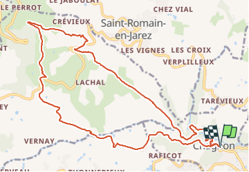
Ruta Senderismo de 13,1 km a descubrir en Auvergne-Rhône-Alpes, Loira, Chagnon. Esta ruta ha sido propuesta por SyMA.
Descripción
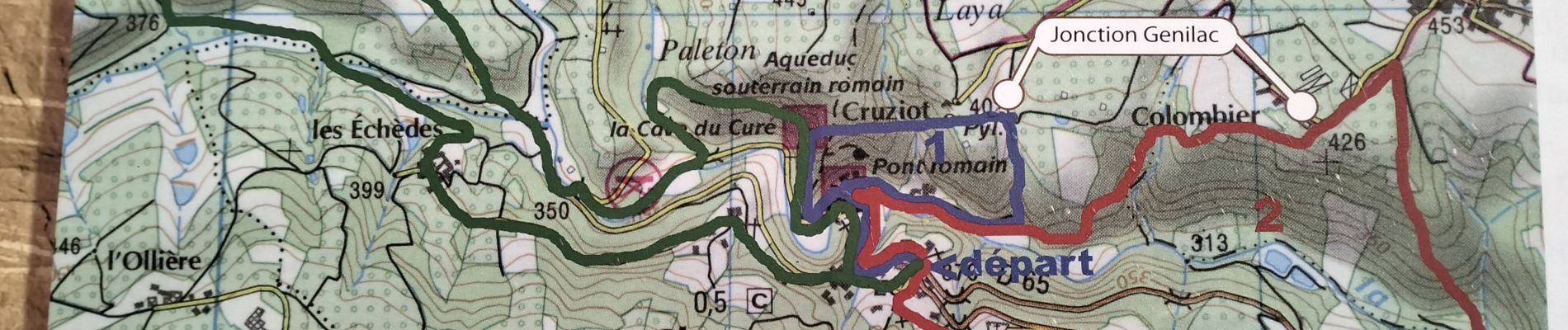
grand Parking à l'entrée de Chagnon (WC derrière la mairie à 200m)
belle vue sur Chagnon évitez de passer la descente et sur le pont si HUMIDE car très glissant
Attention chemin délicat à 6 km
Localización
País:
France
Región :
Auvergne-Rhône-Alpes
Departamento/provincia :
Loira
Municipio :
Chagnon
Localidad:
Unknown
Salida:(Dec)
Salida:(UTM)
621424 ; 5043476 (31T) N.
Comentarios
Excursiones cerca
![Excursión Senderismo La Grand-Croix - MOYENNE MARCHE - Photo](https://media.geolcdn.com/t/375/260/ext.jpg?maxdim=2&url=https%3A%2F%2Fstatic1.geolcdn.com%2Fsiteimages%2Fupload%2Ffiles%2F1553511878bg_sport_marche.png)
![Senderismo Senderismo](https://static1.geolcdn.com/sitytour/trail-icons/101.png)
MOYENNE MARCHE
Senderismo
Muy fácil
(1)
La Grand-Croix,
Auvergne-Rhône-Alpes,
Loira,
France
![](/images/other/stat-length.png)
3,8 km | 5 km-effort
1h 1min
![](https://static1.geolcdn.com/siteimages/upload/files/16400158638029165_repeat_loop_refresh_sync_direction_icon.png)
Sí
![Excursión Senderismo Saint-Joseph - 42-st-joseph-10km-320m - Photo](https://media.geolcdn.com/t/375/260/d6018596-5a38-4194-9525-041abab6ce05.jpg&format=jpg&maxdim=2)
![Senderismo Senderismo](https://static1.geolcdn.com/sitytour/trail-icons/101.png)
42-st-joseph-10km-320m
Senderismo
Fácil
Saint-Joseph,
Auvergne-Rhône-Alpes,
Loira,
France
![](/images/other/stat-length.png)
10,5 km | 14,8 km-effort
2h 50min
![](https://static1.geolcdn.com/siteimages/upload/files/16400158638029165_repeat_loop_refresh_sync_direction_icon.png)
Sí
![Excursión Senderismo Saint-Martin-la-Plaine - 42-martinlaplaine-12km450m - Photo](https://media.geolcdn.com/t/375/260/0bbcbe3d-ff1f-4c48-95ef-874625509cfa.jpg&format=jpg&maxdim=2)
![Senderismo Senderismo](https://static1.geolcdn.com/sitytour/trail-icons/101.png)
42-martinlaplaine-12km450m
Senderismo
Difícil
Saint-Martin-la-Plaine,
Auvergne-Rhône-Alpes,
Loira,
France
![](/images/other/stat-length.png)
12,9 km | 18,9 km-effort
4h 17min
![](https://static1.geolcdn.com/siteimages/upload/files/16400158638029165_repeat_loop_refresh_sync_direction_icon.png)
Sí
![Excursión Senderismo Valfleury - Valfleury - Découverte de ce petit Lourdes et de ses environs - Photo](https://media.geolcdn.com/t/375/260/16f0dea3-73b6-45fe-b6f5-0da3d54ae22a.jpg&format=jpg&maxdim=2)
![Senderismo Senderismo](https://static1.geolcdn.com/sitytour/trail-icons/101.png)
Valfleury - Découverte de ce petit Lourdes et de ses environs
Senderismo
Medio
Valfleury,
Auvergne-Rhône-Alpes,
Loira,
France
![](/images/other/stat-length.png)
6,4 km | 9,5 km-effort
1h 54min
![](https://static1.geolcdn.com/siteimages/upload/files/16400158638029165_repeat_loop_refresh_sync_direction_icon.png)
Sí
![Excursión Senderismo Saint-Martin-la-Plaine - rando autour de St Martin la plaine, - Photo](https://media.geolcdn.com/t/375/260/edbc12e4-5772-4b73-9ba2-a3d81bfb5c32.jpg&format=jpg&maxdim=2)
![Senderismo Senderismo](https://static1.geolcdn.com/sitytour/trail-icons/101.png)
rando autour de St Martin la plaine,
Senderismo
Fácil
Saint-Martin-la-Plaine,
Auvergne-Rhône-Alpes,
Loira,
France
![](/images/other/stat-length.png)
10,4 km | 13,6 km-effort
3h 6min
![](https://static1.geolcdn.com/siteimages/upload/files/16400158638029165_repeat_loop_refresh_sync_direction_icon.png)
Sí
![Excursión Senderismo Cellieu - Cellier Valfleurie - Photo](https://media.geolcdn.com/t/375/260/ddbd041f-9f5b-41f8-ae6c-ee02ff5e9afa.jpg&format=jpg&maxdim=2)
![Senderismo Senderismo](https://static1.geolcdn.com/sitytour/trail-icons/101.png)
Cellier Valfleurie
Senderismo
Medio
Cellieu,
Auvergne-Rhône-Alpes,
Loira,
France
![](/images/other/stat-length.png)
19,3 km | 29 km-effort
4h 37min
![](https://static1.geolcdn.com/siteimages/upload/files/16400158638029165_repeat_loop_refresh_sync_direction_icon.png)
No
![Excursión Senderismo Cellieu - cellieu partiel pournphotos - Photo](https://media.geolcdn.com/t/375/260/fee08f5c-9bca-4082-bdf2-49f590ea9fc1.jpg&format=jpg&maxdim=2)
![Senderismo Senderismo](https://static1.geolcdn.com/sitytour/trail-icons/101.png)
cellieu partiel pournphotos
Senderismo
Medio
Cellieu,
Auvergne-Rhône-Alpes,
Loira,
France
![](/images/other/stat-length.png)
11 km | 17,9 km-effort
2h 37min
![](https://static1.geolcdn.com/siteimages/upload/files/16400158638029165_repeat_loop_refresh_sync_direction_icon.png)
No
![Excursión Senderismo Cellieu - Cellieu - Photo](https://media.geolcdn.com/t/375/260/ext.jpg?maxdim=2&url=https%3A%2F%2Fstatic1.geolcdn.com%2Fsiteimages%2Fupload%2Ffiles%2F1553511878bg_sport_marche.png)
![Senderismo Senderismo](https://static1.geolcdn.com/sitytour/trail-icons/101.png)
Cellieu
Senderismo
Medio
(1)
Cellieu,
Auvergne-Rhône-Alpes,
Loira,
France
![](/images/other/stat-length.png)
19,2 km | 28 km-effort
6h 29min
![](https://static1.geolcdn.com/siteimages/upload/files/16400158638029165_repeat_loop_refresh_sync_direction_icon.png)
Sí
![Excursión Senderismo Saint-Martin-la-Plaine - 20200723...De St-Martin-la-Plaine à Ste Catherine - Photo](https://media.geolcdn.com/t/375/260/de2332cd-f39e-4b4b-833f-13d4f905f3e7.jpg&format=jpg&maxdim=2)
![Senderismo Senderismo](https://static1.geolcdn.com/sitytour/trail-icons/101.png)
20200723...De St-Martin-la-Plaine à Ste Catherine
Senderismo
Medio
Saint-Martin-la-Plaine,
Auvergne-Rhône-Alpes,
Loira,
France
![](/images/other/stat-length.png)
26 km | 36 km-effort
6h 11min
![](https://static1.geolcdn.com/siteimages/upload/files/16400158638029165_repeat_loop_refresh_sync_direction_icon.png)
Sí