![](/images/other/stat-length.png)
![Excursión Senderismo Saint-Amand-les-Eaux - Ronde de la Fontaine bouillon - Photo](https://media.geolcdn.com/t/1900/400/ext.pjpeg?maxdim=2&url=https%3A%2F%2Fstatic1.geolcdn.com%2Fsiteimages%2Fupload%2Ffiles%2F1553511878bg_sport_marche.png)
Ronde de la Fontaine bouillon
corsinou
Usuario
![Longitud](/images/other/stat-length.png)
Longitud
5,7 km
![Altitud máxima](https://static1.geolcdn.com/siteimages/upload/files/1508320355ic_sort_altitude_max_24dp.png)
Altitud máxima
36 m
![Desnivel positivo](https://static1.geolcdn.com/siteimages/upload/files/1508320355ic_sort_den_pos_24dp.png)
Desnivel positivo
39 m
![Km-Effort](/images/other/stat-length.png)
Km-Effort
6,2 km
![Altitud mínima](https://static1.geolcdn.com/siteimages/upload/files/1508320355ic_sort_altitude_min_24dp.png)
Altitud mínima
18 m
![Desnivel negativo](https://static1.geolcdn.com/siteimages/upload/files/1508320355ic_sort_den_neg_24dp.png)
Desnivel negativo
36 m
![Boucle](https://static1.geolcdn.com/siteimages/upload/files/16400158638029165_repeat_loop_refresh_sync_direction_icon.png)
Boucle
Sí
Fecha de creación :
2015-02-16 00:00:00.0
Última modificación :
2015-02-16 00:00:00.0
![Senderismo](https://static1.geolcdn.com/sitytour/trail-icons/101.png)
1h23
Dificultad : Desconocido
![Escanee este código QR para abrir la excursión en la aplicación SityTrail](https://capi.geolives.com/qq0zvz2zws4bq2lad0pu/sitytour/trails/386518/qr.png?size=200)
Aplicación GPS de excursión GRATIS
A propósito
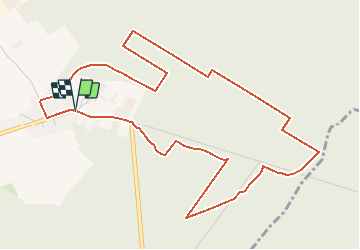
Ruta Senderismo de 5,7 km a descubrir en Alta Francia, Norte, Saint-Amand-les-Eaux. Esta ruta ha sido propuesta por corsinou.
Descripción
Départ à la " Chaine Thermale du Soleil " rue de la fontaine bouillon.
Face à la Chaine partir sur la gauche et emprunter après quelques mètres la route sur votre droite
Puntos de interés
Localización
País:
France
Región :
Alta Francia
Departamento/provincia :
Norte
Municipio :
Saint-Amand-les-Eaux
Localidad:
Unknown
Salida:(Dec)
Salida:(UTM)
533723 ; 5588050 (31U) N.
Comentarios
Excursiones cerca
![Excursión Senderismo Hergnies - Entre terre et eaux - Hergnies - Photo](https://media.geolcdn.com/t/375/260/ext.jpg?maxdim=2&url=https%3A%2F%2Fservices.sitytrail.com%2FGeolivesWS%2FDownloadMedia.ashx%3FTrailID%3D111915%26Media%3D8943_6.jpg)
![Senderismo Senderismo](https://static1.geolcdn.com/sitytour/trail-icons/101.png)
Entre terre et eaux - Hergnies
Senderismo
Difícil
(2)
Hergnies,
Alta Francia,
Norte,
France
![](/images/other/stat-length.png)
13,2 km | 13,9 km-effort
3h 19min
![](https://static1.geolcdn.com/siteimages/upload/files/16400158638029165_repeat_loop_refresh_sync_direction_icon.png)
Sí
![Excursión Senderismo Raismes - Terril du lavoir Rousseau - Photo](https://media.geolcdn.com/t/375/260/55636772-211b-4a0e-95d1-d18ad30169e0.jpg&format=jpg&maxdim=2)
![Senderismo Senderismo](https://static1.geolcdn.com/sitytour/trail-icons/101.png)
Terril du lavoir Rousseau
Senderismo
Medio
Raismes,
Alta Francia,
Norte,
France
![](/images/other/stat-length.png)
5,7 km | 7,2 km-effort
2h 7min
![](https://static1.geolcdn.com/siteimages/upload/files/16400158638029165_repeat_loop_refresh_sync_direction_icon.png)
Sí
![Excursión Senderismo Saint-Amand-les-Eaux - terril vicoigne - Photo](https://media.geolcdn.com/t/375/260/d8552856-5959-4bc8-a6d2-93f721ca17ec.jpg&format=jpg&maxdim=2)
![Senderismo Senderismo](https://static1.geolcdn.com/sitytour/trail-icons/101.png)
terril vicoigne
Senderismo
Fácil
(1)
Saint-Amand-les-Eaux,
Alta Francia,
Norte,
France
![](/images/other/stat-length.png)
8,7 km | 9,7 km-effort
2h 0min
![](https://static1.geolcdn.com/siteimages/upload/files/16400158638029165_repeat_loop_refresh_sync_direction_icon.png)
Sí
![Excursión Senderismo Raismes - terril du lavoir rousseau - Photo](https://media.geolcdn.com/t/375/260/2a750bf1-1f0f-4ec6-9f4d-4d916d2a14af.jpg&format=jpg&maxdim=2)
![Senderismo Senderismo](https://static1.geolcdn.com/sitytour/trail-icons/101.png)
terril du lavoir rousseau
Senderismo
Medio
Raismes,
Alta Francia,
Norte,
France
![](/images/other/stat-length.png)
7,5 km | 9,3 km-effort
2h 0min
![](https://static1.geolcdn.com/siteimages/upload/files/16400158638029165_repeat_loop_refresh_sync_direction_icon.png)
Sí
![Excursión Senderismo Saint-Amand-les-Eaux - notre dame d'amour(NDA), propose par VDN - Photo](https://media.geolcdn.com/t/375/260/630cd120-0ef0-4a83-86e7-91e6331d9f35.jpg&format=jpg&maxdim=2)
![Senderismo Senderismo](https://static1.geolcdn.com/sitytour/trail-icons/101.png)
notre dame d'amour(NDA), propose par VDN
Senderismo
Medio
Saint-Amand-les-Eaux,
Alta Francia,
Norte,
France
![](/images/other/stat-length.png)
9,7 km | 10,6 km-effort
2h 16min
![](https://static1.geolcdn.com/siteimages/upload/files/16400158638029165_repeat_loop_refresh_sync_direction_icon.png)
Sí
![Excursión Senderismo Nivelle - Nivelle- circuit Nivelle-Mortagne-Chateau l'abbaye - Photo](https://media.geolcdn.com/t/375/260/d91e613a-8448-41fc-bfd3-8fd05bd73b48.jpg&format=jpg&maxdim=2)
![Senderismo Senderismo](https://static1.geolcdn.com/sitytour/trail-icons/101.png)
Nivelle- circuit Nivelle-Mortagne-Chateau l'abbaye
Senderismo
Fácil
(1)
Nivelle,
Alta Francia,
Norte,
France
![](/images/other/stat-length.png)
11,5 km | 12,2 km-effort
2h 30min
![](https://static1.geolcdn.com/siteimages/upload/files/16400158638029165_repeat_loop_refresh_sync_direction_icon.png)
Sí
![Excursión Senderismo Château-l'Abbaye - château l'abbaye. entre Escaut et Scarpe - Photo](https://media.geolcdn.com/t/375/260/21c122b9-cbf8-4e60-94a2-4e2f3c16b33a.jpg&format=jpg&maxdim=2)
![Senderismo Senderismo](https://static1.geolcdn.com/sitytour/trail-icons/101.png)
château l'abbaye. entre Escaut et Scarpe
Senderismo
Medio
(1)
Château-l'Abbaye,
Alta Francia,
Norte,
France
![](/images/other/stat-length.png)
8 km | 8,4 km-effort
1h 27min
![](https://static1.geolcdn.com/siteimages/upload/files/16400158638029165_repeat_loop_refresh_sync_direction_icon.png)
Sí
![Excursión Senderismo Wallers - tour d'Hasnon par forêt et ruisseau - Photo](https://media.geolcdn.com/t/375/260/2b9bf806-1bf3-4e60-9b73-d4a339f79ca9.jpg&format=jpg&maxdim=2)
![Senderismo Senderismo](https://static1.geolcdn.com/sitytour/trail-icons/101.png)
tour d'Hasnon par forêt et ruisseau
Senderismo
Fácil
Wallers,
Alta Francia,
Norte,
France
![](/images/other/stat-length.png)
9,8 km | 10,6 km-effort
2h 8min
![](https://static1.geolcdn.com/siteimages/upload/files/16400158638029165_repeat_loop_refresh_sync_direction_icon.png)
Sí
![Excursión Senderismo Saint-Amand-les-Eaux - Mesnil, version plus longue - Photo](https://media.geolcdn.com/t/375/260/e5ac201c-8480-46b8-81d2-a49e027ccf3b.jpg&format=jpg&maxdim=2)
![Senderismo Senderismo](https://static1.geolcdn.com/sitytour/trail-icons/101.png)
Mesnil, version plus longue
Senderismo
Fácil
Saint-Amand-les-Eaux,
Alta Francia,
Norte,
France
![](/images/other/stat-length.png)
9,9 km | 11,1 km-effort
2h 2min
![](https://static1.geolcdn.com/siteimages/upload/files/16400158638029165_repeat_loop_refresh_sync_direction_icon.png)
Sí